


MODIS数据详细介绍网址:https://lpdaac.usgs.gov/product_search/?view=list
包含各个Collection的数据,各种类型的MODIS数据介绍,可以筛选。
MCD19 A1数据介绍 复制自https://lpdaac.usgs.gov/products/mcd19a1v006/
The MCD19A1 Version 6 data product is a Moderate Resolution Imaging Spectroradiometer (MODIS) Terra and Aqua combined Multi-Angle Implementation of Atmospheric Correction (MAIAC) Land Surface Bidirectional Reflectance Factor (BRF)gridded Level 2 product produced daily at 500 meter (m) and 1 kilometer (km) pixel resolutions. The MCD19A1 product is corrected for atmospheric gases and aerosols using a new MAIAC algorithm that is based on a time series analysis and a combination of pixel- and image-based processing. The MODIS MAIAC Land Surface BRF products provide an estimate of the surface spectral reflectance as it would be measured at ground-level in the absence of atmospheric scattering or absorption.
对Bidirectional Reflectance Factor (BRF)的解释:Among atmospherically corrected products, the men-tioned dataset provided both the bidirectional reflectance factors(BRF), often called surface reflectance。摘自论文:《Consistency of vegetation index seasonality across the Amazonrainforest》
MCD19A1包含的信息:
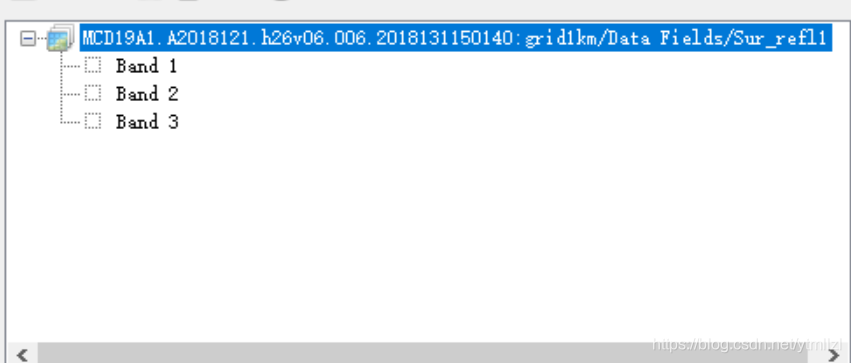
The MCD19A1 MAIAC Surface Reflectance data product includes 34 Science Dataset (SDS) layers: surface reflectance for bands 1-12, BRF uncertainty for bands 1-2, snow fraction, snow grain size, snow fit, Quality Assessment (QA) bits at 1 km, surface reflectance for bands 1-7 at 500 m, cosine of solar zenith angle, cosine of view zenith angle, relative azimuth angle, scattering angle, solar azimuth angle, view azimuth angle, glint angle, RossThick/Li-Sparse (RTLS) volumetric kernel, and RTLS geometric kernel at 5 km. A low-resolution browse image is also included showing surface reflectance band combination 1, 4, 3 created using a composite of all available orbits.
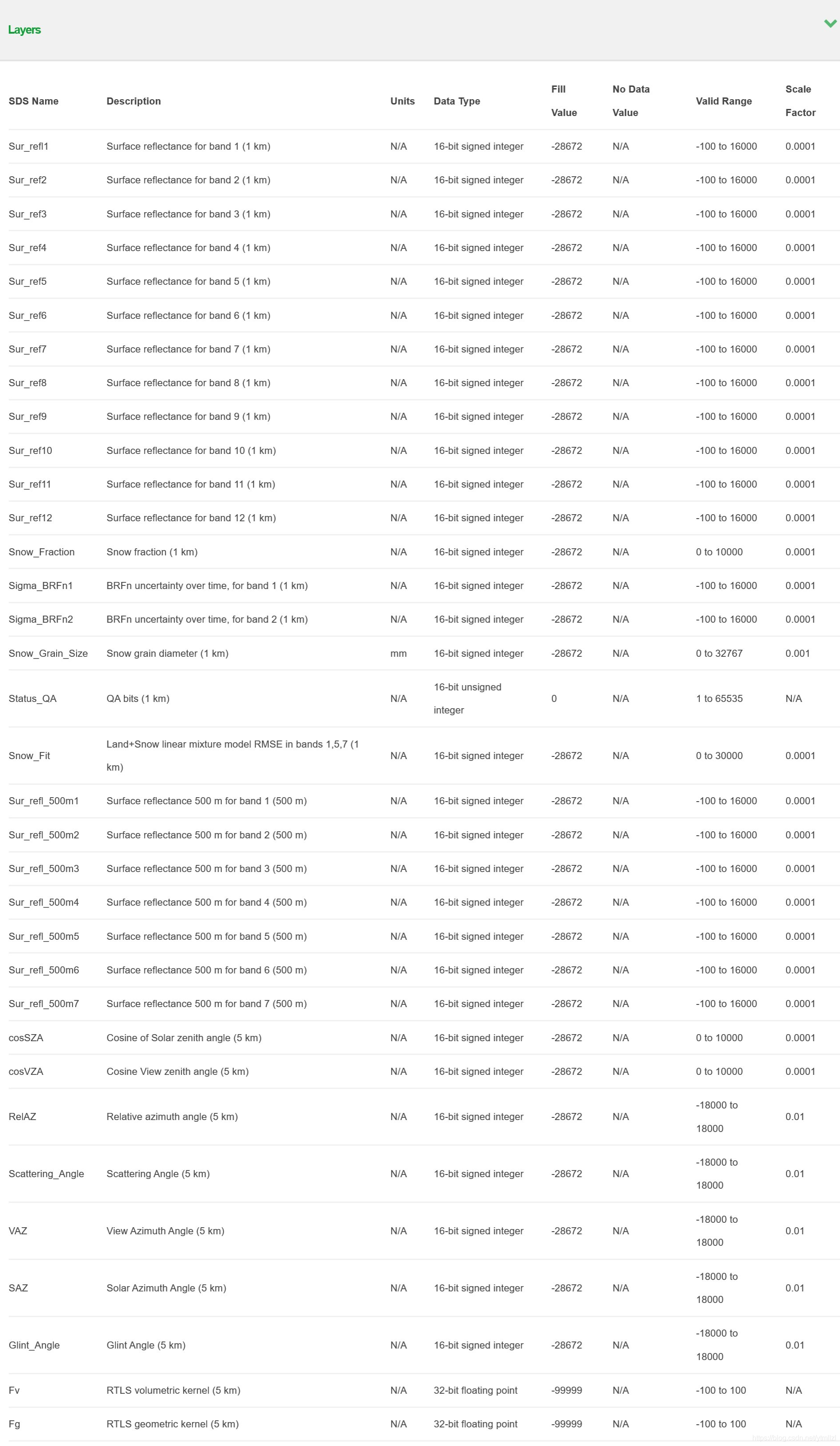
Each SDS layer within each MCD19A1 Hierarchical Data Format 4 (HDF4) file contains a third dimension that represents the number of orbit overpasses. This factor could affect the total number of bands for each SDS layer.
The MCD19 SDS layers are three dimensional. The total number of bands in each file is contingent upon the number of orbit overpasses (1-2 at the equator and up to 30 in Polar Regions). For example, a file with an orbit number of five will contain five bands for each SDS layer (i.e. Snow_Fraction will be recorded in 5 separate instances). Note that at high latitudes, only the first 16 orbits with the largest coverage are selected for processing per day in order to limit the file size.
Orbit information is stored in the Orbit_amount and Orbit_time_stamp attributes in the HDF file. The global metadata attributes of MODIS data products can be viewed in software such as HDFView and Panoply.
MCD19A1的反射率数据是采用MAIAC大气校正的,每个反射率波段是多维的,比如说Band1为第一个波段的反射率,在30°N,band1内还包含3个波段,但是在75°,band1内包含了12个波段。这取决于卫星的过境次数。在高纬度地区(每天有可能会过境30次),为了限制文件大小,每天只选择覆盖范围最大的前16个轨道进行处理。目前理解的就这些,后续再补充。


 109
109

 被折叠的 条评论
为什么被折叠?
被折叠的 条评论
为什么被折叠?
 到【灌水乐园】发言


