osgEarth示例分析——osgearth_eci

前言

osgearth_eci示例,展示了J2000的天体坐标系和ECEF地固系的转换,绘制坐标系,以及读取卫星参数绘制卫星的功能。绘制卫星轨迹,添加差值效果和未添加差值的效果。

关于卫星两行根数的数据文件下载路径:CelesTrak: Historical NORAD Two-Line Element Sets

关于卫星两行根数的解释:CelesTrak: NORAD Two-Line Element Set Format

执行命令

// J2000ECI坐标系下绘制, --tessellate 开启差值功能。最好不要开启
osgearth_ecid.exe earth_image\world.earth --tle F:\osgData\Data\space\gps1-01.txt --tessellate

// 还可以通过 --maxpoints 1000 控制添加跟踪卫星的数量
osgearth_ecid.exe earth_image\world.earth --tle F:\osgData\Data\space\gps1-01.txt --maxpoints 1000 --tessellate

// ECEF地固系下 绘制,--tle 加载的文件,一定要写全路径,否则无法找到文件,即使放入系统环境变量也没用。
osgearth_ecid.exe earth_image\world.earth --tle F:\osgData\Data\space\gps1-01.txt --ecef --tessellate

效果

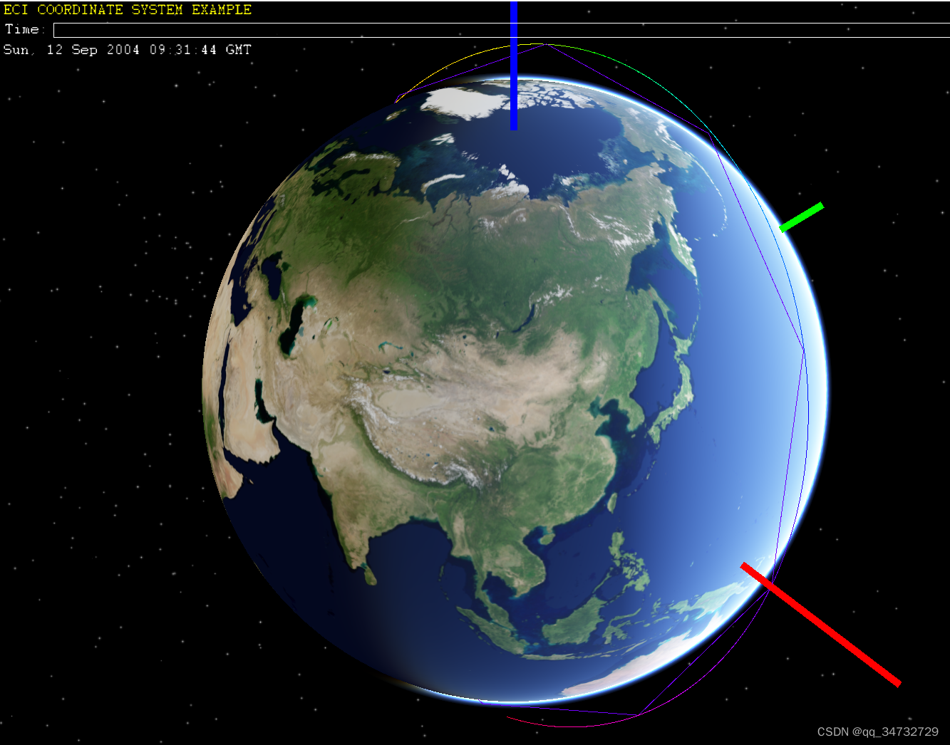
默认J2000ECI坐标系下绘制,此时设置时间为最终时间。共读取了4076条数据。

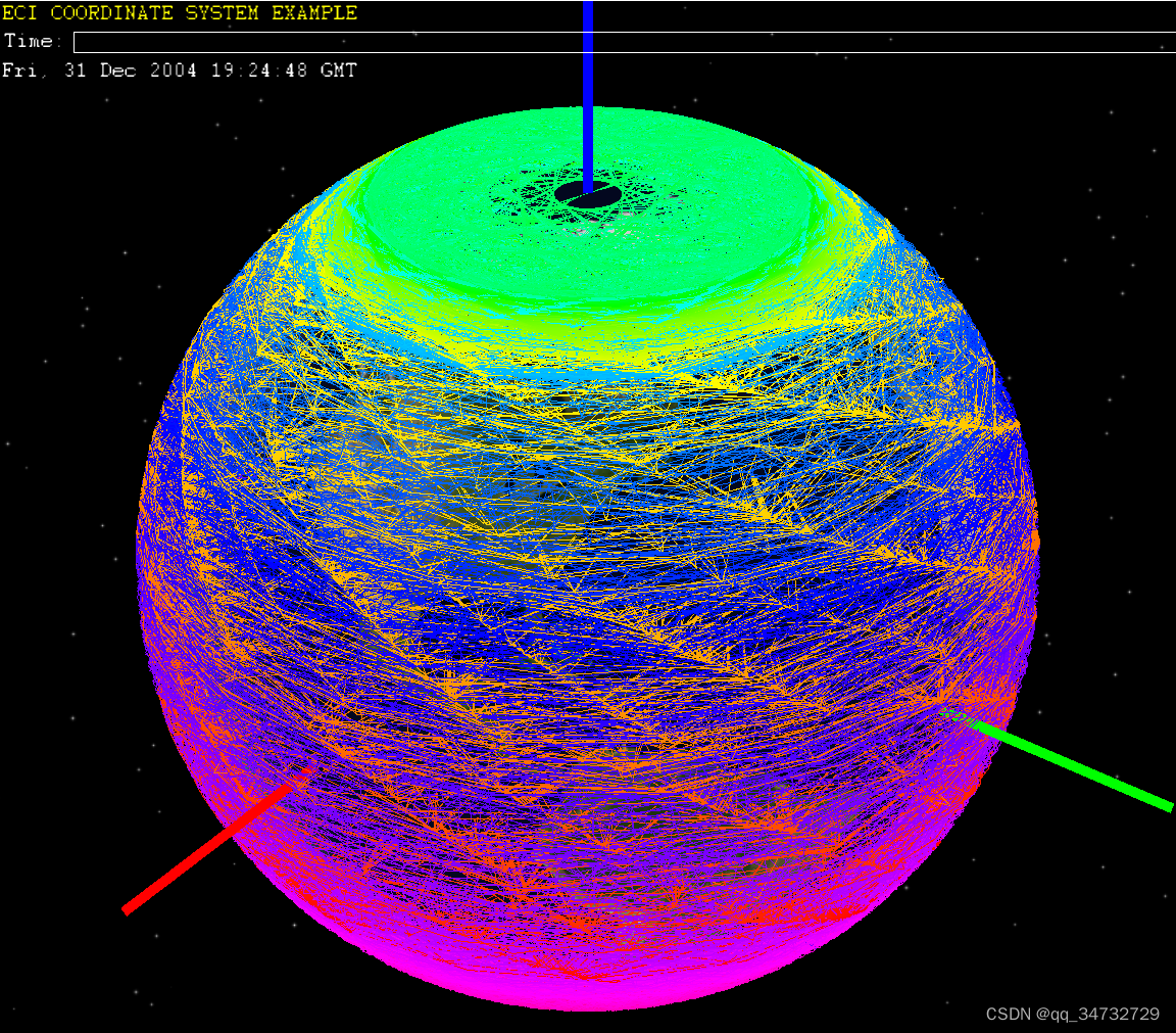
 在ECEF地固坐标系下绘制,此时设置时间为最终时间。共读取了4076条数据。如果代码中app.trackDrawable->load(app.true);参数设置为true,就会出现这种效果。

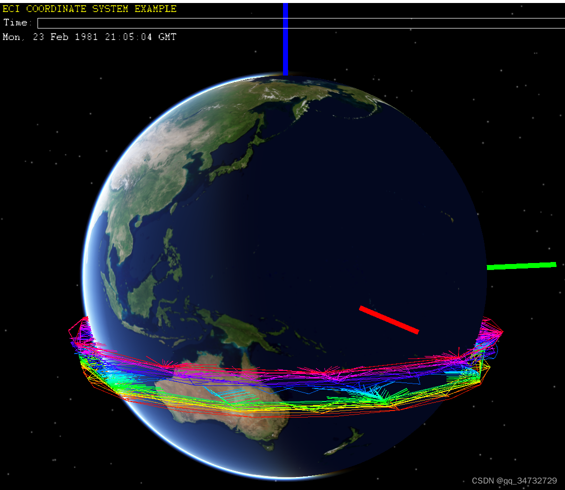
 在ECEF地固坐标系下绘制,此时设置时间为最终时间。共读取了4076条数据。限制绘制100条的情况。如果代码中app.trackDrawable->load(app.true);参数设置为true,就会出现这种效果。

 代码分析

1、J2000ECI坐标系:本例中,以地球为中心,Z轴指向北天极,X轴指向2000年1月1日中午12点的春分点,Y轴与Z、X成右手直角坐标系。所以定义J2000ECI坐标系时,需要定义时间。这个坐标系,是不会随着地球自转的。

2、ECEF地固坐标系:以地球质心为中心,Z轴指向北天极,X轴指向格林尼治天文台零度子午面与协议地球极赤道的交点,Y轴与Z、X成右手直角坐标系。这个坐标系是会随着地球自转而自转的。所以两个坐标系转换,需要乘以地球自转的旋转角矩阵,来实现转换。

3、卫星两行根数:跟据两行根数的各个内容,就可以计算出,卫星什么时候在什么坐标下,且速度、加速度等参数,都会有。

/**
 * Experiment with using a J2000/ECI reference frame as the root of the scene,
 * with the MapNode under an ECI-to-ECEF transform.
 * 尝试使用J2000/ECI参考帧作为场景的根,并在ECI到ECEF变换下使用MapNode。
 */
#include <osgEarth/MapNode>
#include <osgEarth/DateTime>
#include <osgEarth/NodeUtils>
#include <osgEarth/PointDrawable>
#include <osgEarth/CullingUtils>
#include <osgEarth/LineDrawable>
#include <osgEarth/Lighting>
#include <osgEarthUtil/EarthManipulator>
#include <osgEarthUtil/ExampleResources>
#include <osgEarthUtil/Sky>
#include <osgEarthSymbology/Color>
#include <osgEarthAnnotation/LabelNode>
#include <osgViewer/Viewer>
#include <iostream>

#define LC "[eci] "

using namespace osgEarth;
using namespace osgEarth::Util;
using namespace osgEarth::Symbology;
using namespace osgEarth::Annotation;
namespace ui = osgEarth::Util::Controls;

int
usage(const char* name, const char* msg)
{
    OE_NOTICE 
        << "\nUsage: " << name << " [file.earth]\n"
        << "     --tle <filename>    : Load a NORAD TLE file\n"		// 加载tle文件
        << "     --maxpoints <num>   : Limit the track size to <num> points\n"		// 限制要绘制卫星的个数
        << "     --ecef              : View the track in ECEF space instead of ECI\n" // 在ECEF空间而不是ECI中查看轨迹。
        << "     --tessellate        : Add interpolated points to the track data\n"		// 向轨迹数据添加插值点
        << "\nDownload NORAD TLE files from https://www.celestrak.com/NORAD/archives\n\n" // 下载 NORAD TLE 文件地址
        << msg << std::endl;

    return 0;
}

// Reference time for the J2000 ECI coordinate frame 
// J2000 ECI坐标系的参考时间。起始时间为2000年1月1日中午12点整
static DateTime J2000Epoch(2000, 1, 1, 12.00);

// Transform that takes us from a J2000 ECI reference frame 
// to an ECEF reference frame (i.e. MapNode)
// 定义 从J2000ECI坐标系转到ECEF坐标系(地固系)的 转换矩阵
class J2000ToECEFTransform : public osg::MatrixTransform
{
public:
    void setDateTime(const DateTime& dt)
    {
        osg::Matrix matrix = createMatrix(dt);
        setMatrix(matrix);// 设置给父类
    }

	// 根据传入UTC时间,定义当前矩阵
    static osg::Matrix createMatrix(const DateTime& dt)
    {
        // Earth's rotation rate: International Astronomical Union (IAU) GRS 67
		// 地球自转率,即角速度
        const double IAU_EARTH_ANGULAR_VELOCITY = 7292115.1467e-11; // (rad/sec)

		// 都转化为儒略日时间,double类型
        double secondsElapsed = (double)(dt.asTimeStamp() - J2000Epoch.asTimeStamp());
        const double rotation = IAU_EARTH_ANGULAR_VELOCITY * secondsElapsed;// 时间*角速度,得到旋转角度
        
        osg::Matrix matrix;
        matrix.makeRotate(rotation, 0, 0, 1);
        return matrix;
    }
};

// Code to read TLE track data files from https://celestrak.com/NORAD
// 从TLE文件读取跟踪数据的代码
struct ECILocation
{
    DateTime timestamp;     // point time 运行在某个点的时间
    Angle incl;             // inclination 倾角
    Angle raan;             // right ascencion of ascending node 上升节点的右上升
    Distance alt;           // altitude	 高度
    osg::Vec3d eci;         // ECI coordinate ECI坐标系下的点位置
    osg::Vec3d ecef;        // ECEF coordinate  ECEF坐标系下的点位置

    void computeECIAndECEF()// 分别计算两个坐标系
    {
		// 根据从文件中获取的 raan incl alt ,计算eci
        eci =
            osg::Quat(raan.as(Units::RADIANS), osg::Vec3d(0, 0, 1)) *
            osg::Quat(incl.as(Units::RADIANS), osg::Vec3d(1, 0, 0)) *
            osg::Vec3d(alt.as(Units::METERS), 0, 0);
		
		// 根据时间获取转换矩阵
        osg::Matrix eci2ecef = J2000ToECEFTransform::createMatrix(timestamp);
        ecef = eci * eci2ecef;// 计算出ecef下坐标点
    }
};

// ECI跟踪
struct ECITrack : public std::vector<ECILocation>
{
    // interpolate points for a smoother track
	// 差值,使得点连线更圆滑.此算法有问题!!!绘制效果特别差!!!
    void tessellate()
    {
		// 声明一个对象
        ECITrack newTrack;
        for(unsigned k=0; k<size()-1; ++k)
        {
			// 每两个点之间,添加10个点??
            for(float t=0; t<1.0f; t+=0.1)
            {
                const ECILocation& p0 = at(k);
                const ECILocation& p1 = at(k+1);

                newTrack.push_back(ECILocation());
                ECILocation& loc = newTrack.back();
                
                loc.timestamp = DateTime(p0.timestamp.asTimeStamp() + (p1.timestamp.asTimeStamp()-p0.timestamp.asTimeStamp())*t);
                loc.raan.set(p0.raan.as(Units::RADIANS) + (p1.raan.as(Units::RADIANS)-p0.raan.as(Units::RADIANS))*t, Units::RADIANS);
                loc.incl.set(p0.incl.as(Units::RADIANS) + (p1.incl.as(Units::RADIANS)-p0.incl.as(Units::RADIANS))*t, Units::RADIANS);
                loc.alt = p0.alt;
                loc.computeECIAndECEF();
            }
        }
        swap(newTrack);// c1.swap(c2); 交换两个变量的值
    }
};

// 读取TLE文件
class TLEReader
{
public:
    // https://celestrak.com/NORAD/documentation/tle-fmt.php
    bool read(const std::string& filename, ECITrack& track) const
    {
		std::cout << "filename = " << filename << std::endl;
        std::ifstream fin(filename.c_str());

		int i = 0;// 记录读取多少两行根数
        while(!fin.eof())
        {
            std::string line1, line2;

			// 每次从fin中读取两条数据
            std::getline(fin, line1);
            std::getline(fin, line2);
			if (line1.empty() || line2.empty()) {
				std::cout << "line1 or line2 is empty" << std::endl;
				break;
			}  

			++i;// 完成一次读取,则自增一次

			// 新增一个 ECILocation,即一个卫星的参数,并放到列表中
            track.push_back(ECILocation());
            ECILocation& loc = track.back();// 从列表中取出刚放入的卫星数据

			// 将卫星数据,计算后,填充 loc的各个参数:timestamp incl raan alt eci ecef
            // read timestamp
            int year2digit = osgEarth::as<int>(line1.substr(18, 2), 99);
            int year = year2digit > 50? 1900+year2digit : 2000+year2digit;
            double dayOfYear = osgEarth::as<double>(line1.substr(20, 12), 0);
            loc.timestamp = DateTime(year, dayOfYear);

            // read ra/decl
            loc.incl.set(osgEarth::as<double>(line2.substr(8,8),0), Units::DEGREES);
            loc.raan.set(osgEarth::as<double>(line2.substr(17,8),0), Units::DEGREES);
            loc.alt.set(6371 + 715, Units::KILOMETERS);

            loc.computeECIAndECEF();
        }
		std::cout << "共解析数据条数:" << i << std::endl;
        OE_INFO << "Read " << track.size() << " track points" << std::endl;
        return true;
    }
};

// If the "global" coordinate system is ECI, you can put this transform
// under the MapNode (in ECEF space) to "revert" to that global ECI frame.
// Useful if you want to put ECI-space data under the MapNode.
// 如果“全局”坐标系是ECI,则可以将ECI坐标系变换放在MapNode(在ECEF空间中)下,
// 然后再“还原”到该全局ECI坐标系。
// 如果要将ECI空间数据放在MapNode下,则非常有用。
class ECIReferenceFrame : public osg::Group
{
public:
    ECIReferenceFrame()
    {
		// 关闭光照
        Lighting::set(getOrCreateStateSet(), osg::StateAttribute::OFF);
    }

	// 遍历
    void traverse(osg::NodeVisitor& nv)
    {
        osgUtil::CullVisitor* cv = Culling::asCullVisitor(nv);
        if (cv)
        {
            const osg::Camera* cam = cv->getRenderStage()->getCamera();
			// 添加模型视口矩阵
            cv->pushModelViewMatrix(new osg::RefMatrix(cam->getViewMatrix()), osg::Transform::ABSOLUTE_RF);
            osg::Group::traverse(nv);
            cv->popModelViewMatrix();// 再移除该矩阵
        }
        else osg::Group::traverse(nv);
    }
};

// Loads up an ECITrack for display as a series of points.
// 加载ECITrack以显示为一系列线/点。对LineDrawble类不太熟悉
class ECITrackDrawable : public LineDrawable //public PointDrawable
{
public:
    ECITrackDrawable() : LineDrawable(GL_LINE_STRIP)
    {
        Lighting::set(getOrCreateStateSet(), 0);
        //setPointSmooth(true);
        //setPointSize(4.0f);
    }

	// 通过 滑块 设置时间
    void setDateTime(const DateTime& dt)
    {
		// getVertexAttribArray(); 属于爷爷类的方法
		// 获取到当前顶点的时间
        osg::FloatArray* times = dynamic_cast<osg::FloatArray*>(getVertexAttribArray(6));
        unsigned i;
        for (i = 0; i < getNumVerts(); ++i)
        {
            if (dt.asTimeStamp() < getVertexAttrib(times, i))// getVertexAttrib() 父类方法
                break;
        }
        setCount(i);
    }
    
	// 加载 track 列表的所有数据
    void load(const ECITrack& track, bool drawECEF)
    {
        osg::FloatArray* times = new osg::FloatArray();
        times->setBinding(osg::Array::BIND_PER_VERTEX);
        setVertexAttribArray(6, times);// 调用爷爷类的方法

        osg::Vec4f HSLA;// 颜色变量
        Color color;

		// 循环处理每一个卫星
        for(unsigned i=0; i<track.size(); ++i)
        {
            const ECILocation& loc = track[i];
            pushVertex(drawECEF? loc.ecef : loc.eci);// 根据坐标系类型,决定用哪个点进行绘制
            pushVertexAttrib(times, (float)loc.timestamp.asTimeStamp());// 添加属性
            
            // simple color ramp 随机生成颜色
            HSLA.set((float)i/(float)(track.size()-1), 1.0f, 1.0f, 1.0f);
            color.fromHSL(HSLA);
            setColor(i, color);      
        }
        finish();// 更新
    }
};

// 创建J2000ECI坐标系的坐标轴
osg::Node* createECIAxes()
{
	// 坐标轴长度
    const float R = 10e6;
    LineDrawable* d = new LineDrawable(GL_LINES);
    d->allocate(6);

	// X轴
    d->setVertex(0, osg::Vec3(0,0,0));
    d->setColor(0, osg::Vec4(1,0,0,1));
    d->setVertex(1, osg::Vec3(R,0,0));
    d->setColor(1, osg::Vec4(1,0,0,1));

	// Y轴
    d->setVertex(2, osg::Vec3(0,0,0));
    d->setColor(2, osg::Vec4(0,1,0,1));
    d->setVertex(3, osg::Vec3(0,R,0));
    d->setColor(3, osg::Vec4(0,1,0,1));

	// Z轴
    d->setVertex(4, osg::Vec3(0,0,0));
    d->setColor(4, osg::Vec4(0,0,1,1));
    d->setVertex(5, osg::Vec3(0,0,R));
    d->setColor(5, osg::Vec4(0,0,1,1));

	// 坐标轴宽度
    d->setLineWidth(10);
    return d;
}

// Application-wide data and control structure
// 应用程序范围的数据和控制结构
struct App
{
    DateTime start, end;	// 时间
    HSliderControl* time;	// 时间滑块
    LabelControl* timeLabel;// 时间标签
    SkyNode* sky;			// 深空节点
    J2000ToECEFTransform* ecef;	// 坐标系转换矩阵
    osg::Group* eci;
    ECITrackDrawable* trackDrawable;// ECI跟踪绘制
    ECITrack track;				// J2000坐标系下卫星数据列表

    App() 
    {
        trackDrawable = 0L;
        start = J2000Epoch;// 设置为J2000坐标系的开始时间
        end = start + 24.0; // 初始设置时,必须保证start和end保持间距,且start < end
    }

	// 通过滑块设置时间
    void setTime()
    {
		// 获取最新时间
        DateTime newTime(time->getValue());

        if (sky)
            sky->setDateTime(newTime);

		// 如果是地固系,则需要根据时间旋转坐标系
        if (ecef)
            ecef->setDateTime(newTime);

        if (trackDrawable)
            trackDrawable->setDateTime(newTime);

		// 设置时间的显示
        timeLabel->setText(newTime.asRFC1123());
    }
};

// 将app.setTime 设置到这个宏定义中,之前其他例子有涉及到此宏定义的用法
OE_UI_HANDLER(setTime);


int
main(int argc, char** argv)
{
    osg::ArgumentParser arguments(&argc,argv);
    if ( arguments.read("--help") )
        return usage(argv[0], "");

	// 声明app变量
    App app;

    // Read in an optiona TLE track data file
	// 读取TLE文件获取数据
    std::string tlefile;
    if (arguments.read("--tle", tlefile))
    {
		// 读取并解析卫星数据,到app.track列表中
        TLEReader().read(tlefile, app.track);
        if (!app.track.empty())
        {
            int maxPoints;
            if (arguments.read("--maxpoints", maxPoints) && app.track.size() > maxPoints)
                app.track.resize(maxPoints);// 是否需要调整vector空间大小
			if (arguments.read("--tessellate")) {// 是否开启差值功能。最好不要开启,算法有点问题
				app.track.tessellate();
				std::cout << "开启差值功能 tessellate" << std::endl;
			}
            app.start = app.track.front().timestamp;// 设置开始时间
            app.end   = app.track.back().timestamp; // 设置结束时间
        }
    }

    osgViewer::Viewer viewer(arguments);
    viewer.setCameraManipulator( new EarthManipulator(arguments) );

	bool drawECEF = arguments.read("--ecef");

    ui::VBox* container = new ui::VBox();
    container->setChildSpacing(3);
	// 根据是否为ECI坐标系,更改标题
	if (drawECEF) {
		container->addControl(new ui::LabelControl("ECEF COORDINATE SYSTEM EXAMPLE", Color::Red));
	}
	else {
		container->addControl(new ui::LabelControl("ECI COORDINATE SYSTEM EXAMPLE", Color::Yellow));
	}

    // UI control to modify the time of day.
    ui::HBox* h = container->addControl(new ui::HBox());
    h->addControl(new ui::LabelControl("Time:"));
    app.time = h->addControl(new HSliderControl(
        app.start.asTimeStamp(), app.end.asTimeStamp(), app.end.asTimeStamp(),
        new setTime(app)));
    app.time->setWidth(500);// 500宽度太大了,修改小一些,也没有起作用,注释带此行,也没啥变化。
    app.timeLabel = container->addControl(new LabelControl());

    // Load an earth file  
    osg::Node* earth = MapNodeHelper().load(arguments, &viewer, container);
    if (earth)
    {
        // New scene graph root
        osg::Group* root = new osg::Group();

        // First create a Sky which we will place in the (default) ECI frame.
        SkyOptions skyOptions;
		if (drawECEF) {
			// 不太确定这里的 skyOptions.coordinateSystem() 设置为 COORDSYS_ECEF,是否正确,但运行效果没问题。
			skyOptions.coordinateSystem() = SkyOptions::COORDSYS_ECEF;// 地固坐标系
			std::cout << "ecef 坐标系" << std::endl;
		}
		else {
			skyOptions.coordinateSystem() = SkyOptions::COORDSYS_ECI;// 深空坐标系
			std::cout << "eci 坐标系" << std::endl;
		}
        app.sky = SkyNode::create(MapNode::get(earth));// 创建深空节点
        app.sky->attach(&viewer);
        app.sky->getSunLight()->setAmbient(osg::Vec4(0.5,0.5,0.5,1.0));// 环境光
        root->addChild(app.sky);
        
        // A special transform takes us from the ECI into an ECEF frame
        // based on the current date and time.
        // The earth (MapNode) lives here since it is ECEF.
        app.ecef = new J2000ToECEFTransform();// 坐标系转换
        app.sky->addChild(app.ecef);
        app.ecef->addChild(earth);// 将地球节点加入到坐标转换矩阵中
        
        // This group holds data in the ECI frame.
        app.eci = new ECIReferenceFrame();
        app.eci->addChild(createECIAxes());// 添加坐标轴
        MapNode::get(earth)->addChild(app.eci);

        // Track data
        if (!app.track.empty())
        {
            app.trackDrawable = new ECITrackDrawable();

            if (drawECEF)// 地固系,绘制连线
            {
                app.trackDrawable->load(app.track, false);// 如果设置为true,则会出现很多杂乱的线
                MapNode::get(earth)->addChild(app.trackDrawable);
				std::cout << "ecef 坐标系" << std::endl;
            }
            else // J2000坐标系,不绘制连线
            {
                app.trackDrawable->load(app.track, false);// 如果设置为true,则会出现很多杂乱的线
                app.eci->addChild(app.trackDrawable);
				std::cout << "eci 坐标系" << std::endl;
            }
        }

        viewer.realize();
        app.time->setWidth(viewer.getCamera()->getViewport()->width()-40);

        app.setTime();
        viewer.setSceneData(root);
        viewer.run();
    }
    else
    {
        return usage(argv[0], "Bad earth file");
    }

    return 0;
}

osgEarth 的 121 个案例详解 osgEarth 的 121 个案例详解 ...........................................................................................................1 1. aeqd.earth.................................................................................................................................4 2. annotation.earth .......................................................................................................................5 3. annotation_dateline.earth........................................................................................................6 4. annotation_dateline_projected.earth ......................................................................................8 5. annotation_flat.earth................................................................................................................8 6. arcgisonline.earth .....................................................................................................................9 7. bing.earth................................................................................................................................10 8. boston.earth............................................................................................................................11 9. boston_buildings.earth ...........................................................................................................12 10. boston_projected.earth ..................................................................................................13 11. boston_tfs.earth..............................................................................................................14 12. boston-gpu.earth ............................................................................................................15 13. bumpmap.earth ..............................................................................................................16 14. clouds.earth ....................................................................................................................17 15. colorramp.earth ..............................................................................................................18 16. contourmap.earth ...........................................................................................................19 17. datum_override.earth.....................................................................................................20 18. day_night_mp.earth........................................................................................................21 19. day_night_rex.earth........................................................................................................21 20. detail_texture.earth ........................................................................................................21 21. errors.earth .....................................................................................................................22 22. fade_elevation.earth.......................................................................................................22 23. feature_clip_plane.earth.................................................................................................23 24. feature_country_boundaries.earth.................................................................................24 25. feature_custom_filters.earth ..........................................................................................25 26. feature_draped_lines.earth ............................................................................................26 27. feature_draped_polygons.earth .....................................................................................27 28. feature_elevation.earth ..................................................................................................28 29. feature_extrude.earth.....................................................................................................29 30. feature_geom.earth ........................................................................................................30 31. feature_gpx.earth............................................................................................................31 32. feature_inline_geometry.earth.......................................................................................32 33. feature_labels.earth........................................................................................................33 34. feature_labels_script.earth.............................................................................................35 35. feature_levels_and_selectors.earth................................................................................35 36. feature_model_scatter.earth ..........................................................................................36 37. feature_models.earth .....................................................................................................37 38. feature_occlusion_culling.earth......................................................................................38osgEarth 编辑器 SXEarth www.sxsim.com 2 39. feature_offset_polygons.earth .......................................................................................38 40. feature_overlay.earth......................................................................................................39 41. feature_poles.earth.........................................................................................................40 42. feature_population_cylinders.earth ...............................................................................40 43. feature_raster.earth ........................................................................................................41 44. feature_rasterize.earth ...................................................................................................41 45. feature_rasterize_2.earth ...............................................................................................42 46. feature_scripted_styling.earth........................................................................................43 47. feature_scripted_styling_2.earth....................................................................................43 48. feature_scripted_styling_3.earth....................................................................................43 49. feature_style_selector.earth ...........................................................................................44 50. feature_tfs.earth .............................................................................................................45 51. feature_tfs_scripting.earth .............................................................................................46 52. feature_wfs.earth............................................................................................................47 53. fractal_elevation.earth....................................................................................................47 54. gdal_multiple_files.earth ................................................................................................47 55. gdal_tiff.earth..................................................................................................................48 56. geomshader.earth ...........................................................................................................49 57. glsl.earth..........................................................................................................................50 58. glsl_filter.earth ................................................................................................................51 59. graticules.earth ...............................................................................................................52 60. hires-inset.earth..............................................................................................................53 61. intersect_filter.earth .......................................................................................................54 62. land_cover_mixed.earth .................................................................................................55 63. layer_opacity.earth .........................................................................................................55 64. ldb.earth..........................................................................................................................56 65. mapbox.earth..................................................................................................................56 66. mask.earth ......................................................................................................................57 67. mb_tiles.earth.................................................................................................................58 68. mercator_to_plate_carre.earth ......................................................................................59 69. mgrs_graticule.earth.......................................................................................................60 70. min_max_level.earth ......................................................................................................60 71. min_max_range.earth.....................................................................................................61 72. min_max_range_rex.earth..............................................................................................62 73. min_max_resolutions.earth............................................................................................62 74. multiple_heightfields.earth.............................................................................................64 75. night.earth.......................................................................................................................65 76. nodata.earth ...................................................................................................................65 77. noise.earth ......................................................................................................................68 78. normalmap.earth ............................................................................................................68 79. ocean.earth .....................................................................................................................69 80. ocean_no_elevation.earth ..............................................................................................69 81. openstreetmap.earth......................................................................................................69 82. openstreetmap_buildings.earth .....................................................................................70osgEarth 编辑器 SXEarth www.sxsim.com 3 83. openstreetmap_flat.earth...............................................................................................70 84. openstreetmap_full.earth...............................................................................................70 85. openweathermap_clouds.earth......................................................................................71 86. openweathermap_precipitation.earth ...........................................................................71 87. openweathermap_pressure.earth ..................................................................................71 88. photosphere1.earth ........................................................................................................71 89. photosphere2.earth ........................................................................................................72 90. readymap.earth...............................................................................................................73 91. readymap_flat.earth .......................................................................................................73 92. readymap_include.earth.................................................................................................74 93. readymap_template.earth..............................................................................................74 94. readymap-elevation-only.earth.......................................................................................74 95. readymap-osm.earth ......................................................................................................75 96. readymap-priority.earth..................................................................................................75 97. readymap-rex.earth ........................................................................................................75 98. roads.earth......................................................................................................................76 99. roads-flattened.earth......................................................................................................76 100. roads-test.earth...............................................................................................................76 101. scene_clamping.earth.....................................................................................................76 102. silverlining.earth..............................................................................................................78 103. simple_model.earth........................................................................................................78 104. skyview1.earth ................................................................................................................79 105. skyview2.earth ................................................................................................................80 106. splat.earth .......................................................................................................................81 107. splat-blended-with-imagery.earth ..................................................................................81 108. splat-with-mask-layer.earth.............................................................................................81 109. splat-with-multiple-zones.earth......................................................................................82 110. splat-with-rasterized-land-cover.earth............................................................................82 111. stamen_toner.earth ........................................................................................................82 112. stamen_watercolor.earth................................................................................................82 113. state_plane.earth............................................................................................................82 114. tess_screen_space.earth.................................................................................................82 115. tess-coastlines.earth .......................................................................................................82 116. tess-terrain.earth ............................................................................................................83 117. triton.earth......................................................................................................................83 118. triton_drop_shader.earth................................................................................................83 119. utm.earth ........................................................................................................................83 120. utm_graticule.earth ........................................................................................................83 121. vertical_datum.earth ......................................................................................................83 122. wms_nexrad.earth ..........................................................................................................84 123. wms-t_nexrad_animated.earth ......................................................................................84 124. 编辑问题总结....................................................................................错误!未定义书签。
评论 2
添加红包

请填写红包祝福语或标题

红包个数最小为10个

红包金额最低5元

当前余额3.43前往充值 >
需支付:10.00
成就一亿技术人!
领取后你会自动成为博主和红包主的粉丝 规则
hope_wisdom
发出的红包
实付
使用余额支付
点击重新获取
扫码支付
钱包余额 0

抵扣说明:

1.余额是钱包充值的虚拟货币,按照1:1的比例进行支付金额的抵扣。
2.余额无法直接购买下载,可以购买VIP、付费专栏及课程。

余额充值