


 超级会员免费看
一、思路
先设置地图节点,把.earth地图文件读取到地图节点里,然后再创建一个模型节点,读取.osg模型文件进入模型节点,并通过computeLocalToWorldTransformFromLatLongHeight函数设置模型出现的坐标及高度,最终显示
setViewpoint方向角是顺时针旋转的,默认朝向正北,旋转90朝向正东,旋转-90朝向正西。
matrix的旋转和 setViewpoint相反,matrix为顺时针。
俯仰角-90度为垂直向下,0度为水平方向。
二、代码
earth+model.cpp文件
#include <Windows.h>
#include <vector>
#include <iostream>
#include <fstream>
#include <cstring>
#include <time.h>
#include <osgEarth/MapNode>
#include <osgEarthUtil/EarthManipulator>
#include <osgEarthUtil/ExampleResources>
//键盘事件
#include<osgViewer/ViewerEventHandlers>
//osgGA相关的库
#include<osgGA/StateSetManipulator>

#include <osgViewer/Viewer>
#include <osgDB/WriteFile>

using namespace std;


int main(int argc, char* argv[])
{
	osg::ref_ptr<osgViewer::Viewer>viewer = new osgViewer::Viewer;
	//添加状态事件,可以相应键盘和鼠标事件,响应L T B W
	viewer->addEventHandler(new osgGA::StateSetManipulator(viewer->getCamera()->getOrCreateStateSet()));
	//窗口大小变化,响应F
	viewer->addEventHandler(new osgViewer::WindowSizeHandler);
	//添加路径记录 Z
	viewer->addEventHandler(new osgViewer::RecordCameraPathHandler);
	//帮助文档显示H
	viewer->addEventHandler(new osgViewer::HelpHandler);
	//截屏 C
	viewer->addEventHandler(new osgViewer::ScreenCaptureHandler);
	//添加一些常用状态设置,响应S
	viewer->addEventHandler(new osgViewer::StatsHandler);

	//操作器
	osg::ref_ptr<osgEarth::Util::EarthManipulator> earthManipulator = new osgEarth::Util::EarthManipulator;
	//设置相机操作器
	viewer->setCameraManipulator(earthManipulator);
	//根节点
	osg::ref_ptr<osg::Group>root = new osg::Group;

	//加载地球节点
	osg::Node* earthNode = osgDB::readNodeFile("clear.earth");
	//将地球节点加入根节点
	root->addChild(earthNode);
	//设置现场数据
	viewer->setSceneData(root.get());
	//实现
	viewer->realize();

	//检测地图节点是否创建好
	osgEarth::MapNode* mapNode = osgEarth::MapNode::findMapNode(earthNode);
	if (!mapNode) return 0;

	//空间设置,水平和垂直
	const osgEarth::SpatialReference* geoSRS = mapNode->getMapSRS()->getGeographicSRS();

	//添加模型
	osg::Node* model = osgDB::readNodeFile("cessna.osg");
	//osg中光照只会对有法线的模型起作用,而模型经过缩放后法线是不会变得,
	//所以需要手动设置属性,让法线随着模型大小变化而变化。GL_NORMALIZE 或 GL_RESCALE_NORMAL
	model->getOrCreateStateSet()->setMode(GL_RESCALE_NORMAL, osg::StateAttribute::ON);

	osg::Matrix Lmatrix;
	geoSRS->getEllipsoid()->computeLocalToWorldTransformFromLatLongHeight(osg::DegreesToRadians(40.0), osg::DegreesToRadians(116.0), 500000.0, Lmatrix);  //维度,经度,高度,localToWorld
	//放大一些,方便看到
	Lmatrix.preMult(osg::Matrix::scale(osg::Vec3(30000, 30000, 30000)));//x,y,z轴放大倍数

	osg::MatrixTransform* mt = new osg::MatrixTransform;
	mt->setMatrix(Lmatrix);
	mt->addChild(model);
	root->addChild(mt);

	viewer->setSceneData(root);

	//视点定位北京地区,此句代码运行后可以直接定位到该坐标,注释后仍能正常显示模型,不过不会自动定位
	earthManipulator->setViewpoint(osgEarth::Viewpoint("模拟无人机", 116, 40, 0.0, 0.0, -90.0, 1.5e6));
	return viewer->run();
}
world.earth里面读取的是world.tif文件,所以地图信息相当于在地球上贴了一张图片,如果想像谷歌地球那样看到细节信息,需要读取其他在线地图文件,例如arcgisonline.earth,加载速度会相对慢一些。
world.earh文件
<map>
	<image name="bluemarble" driver="gdal">
	<url>world.tif</url>
	</image>
</map>
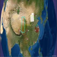
三、结果展示


osgearth读取多个osg模型文件


 4281
4281


 被折叠的 条评论
为什么被折叠?
被折叠的 条评论
为什么被折叠?
 到【灌水乐园】发言


