


 MODIS是美国宇航局(NASA)的大型空间传感器,用于地球观测。它在Terra和Aqua卫星上运行,提供高分辨率的多光谱图像。数据经过五个级别的处理,从原始辐射校正到大气校正和地理定位。MODIS数据涵盖了大气、陆地、冰川和海洋等多个领域的应用,如表面反射率、气候研究和灾害监测。
MODIS 是美国宇航局研制的一种大型空间 传感器,全称为 MoDerate Resolution Imaging Spectroradiometer。
它搭载在两颗卫星上:Terra(EOS AM-1)和 Aqua(EOS PM-1)。
传感器参数
| 扫描带宽(viewing swath) | 2330km |
| 时间分辨率 | 1天(1~2天覆盖整个地球一次) |
| 光谱波段(spectral bands) | 36个,0.405 ~ 14.385 µm(可见光 ~ 热红外) |
| 空间分辨率 | 250m (1-2 波段)、500m (3-7 波段) 、1000m(8-36 波段) |
卫星概况
| Terra | Aqua | |
| 发射时间 | 1999年12月18日 | 2002年5月4日 |
| 过境时间 | 10:30 AM、10:30 PM | 1:30 AM、1:30 PM |
| 数据命名 | MOD Day(10:30AM)、Night(10:30 PM) | MYD Night(1:30AM)、Day(1:30 PM) |
| 传感器 | MODIS、CERES、 ASTER、MOPITT、MISR | MODIS、CERES、 AIRS、AMSU-A、AMSU-E、HSB |
数据传输过程
1、把数据从卫星传输出来
Tracking and Data Relay Satellite System (TDRSS)
2、在地面接收卫星数据
White Sands 和 New Mexico 的地面站
3、收集并整理数据
Goddard Space Flight Center,EOS Data and Operations System (EDOS)
4、数据处理
MODIS Adaptive Processing System (MODAPS)
Ocean Color Data Processing System (OCDPS)
5、用户如何获取数据
官方途径
(1)Level 1、geolocation、cloud mask、Atmosphere products
LAADS web:ladsweb.nascom.nasa.gov
(2)Land Products
Land Processes DAAC at US Geological Survey EROS Data Center (EDC):lpdaac
(3)Cryosphere data products (snow and sea ice cover)
National Snow and Ice Data Center (NSIDC) in Boulder, Colorado:nsidc/daac/modis
(4)Ocean color products、sea surface temperature products
OCDPS at GSFC:oceancolor.gsfc.nasa.gov
个人途径
X-波段接收器,MODIS Direct Broadcast signal
MODIS网格
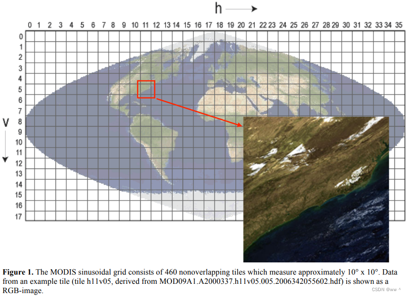
MODIS正弦投影网格系统(MODIS sinusoidal grid)将全球划分为460个互不重叠的规则瓦片(tile),每个瓦片覆盖约10° × 10°的地理范围。
tile的命名格式为“hXXvYY”。XX为水平方向的编号,00-35。YY为垂直方向的编号,00-17。
比如下图中的h11v05,对应于经度110°W—100°W、纬度50°N—60°N的范围。
产品层次
大多数卫星数据处理系统都包括 5 种层次的处理:
- Level 0:原始数据(raw satellite feeds)
- Level 1:只经过辐射校正
- Level 2:将 Level 1 数据进行大气校正,生产出地表反射率产品
- Level 3:将 Level 2 投影到地图网格上,且通常经过时间合成
- Level 4:经过额外处理的产品
Level 0 ~ 2 都是非网格的轨道条带格式;为方便处理,每个条带通常会切成小段或颗粒(segments, or granules)。
Level 3 及以上的数据会地理定位到特定的地图投影中,地理定位产品通常位于一组不重叠的切片(non-overlapping tiles)中。
产品类型
Level 1
MODIS Raw Radiances
MODIS Calibrated Radiances
MODIS Geolocation Fields
MODIS Atmosphere Products
MODIS Aerosol Product
MODIS Total Precipitable Water
MODIS Cloud Product
MODIS Atmospheric Profiles
MODIS Atmosphere Joint Product
MODIS Atmosphere Gridded Product
MODIS Cloud Mask
MODIS Land Products
MODIS Surface Reflectance (MOD09)
MODIS Land Surface Temperature and Emissivity (MOD11)
MODIS Land Surface Temperature and Emissivity (MOD21)
MODIS Land Cover Products
MODIS Vegetation Index Products (NDVI and EVI)
MODIS Thermal Anomalies - Active Fires
MODIS Fraction of Photosynthetically Active Radiation (FPAR) / Leaf Area Index (LAI)
MODIS Evapotranspiration
MODIS Gross Primary Productivity (GPP) / Net Primary Productivity (NPP)
MODIS Global Water Reservoir
MODIS Bidirectional Reflectance Distribution Function (BRDF) / Albedo Parameter
MODIS Vegetation Continuous Fields
MODIS Water Mask
MODIS Burned Area Product
MODIS Cryosphere Products
MODIS Snow Cover
MODIS Sea Ice and Ice Surface Temperature
MODIS Ocean Products
MODIS Sea Surface Temperature
MODIS Remote Sensing Reflectance
MODIS Apparent Visible Wavelength
MODIS Chlorophyll-a Concentration
MODIS Diffuse Attenuation at 490 nm
MODIS Inherent Optical Properties
MODIS Phytoplankton Carbon
MODIS Particulate Organic Carbon
MODIS Particulate Inorganic Carbon
MODIS Normalized Fluorescence Line Height (FLH)
MODIS Instantaneous Photosynthetically Available Radiation
MODIS Daily Mean Photosynthetically Available Radiation


 783
783

 被折叠的 条评论
为什么被折叠?
被折叠的 条评论
为什么被折叠?
 到【灌水乐园】发言


