


土地利用/土地覆盖数据是开展地理、生态、环境等研究的基础数据,本文对目前主流且开源的土地利用数据进行整理,随时更新,欢迎补充!
1. GlobeLand30
中国向联合国提供的首个全球地理信息公共产品,被国际同行专家誉为“对地观测与地理信息开放共享的里程碑”。全球数据可分幅下载,数据质量较高。但数据量较大,下载和拼接处理较慢。
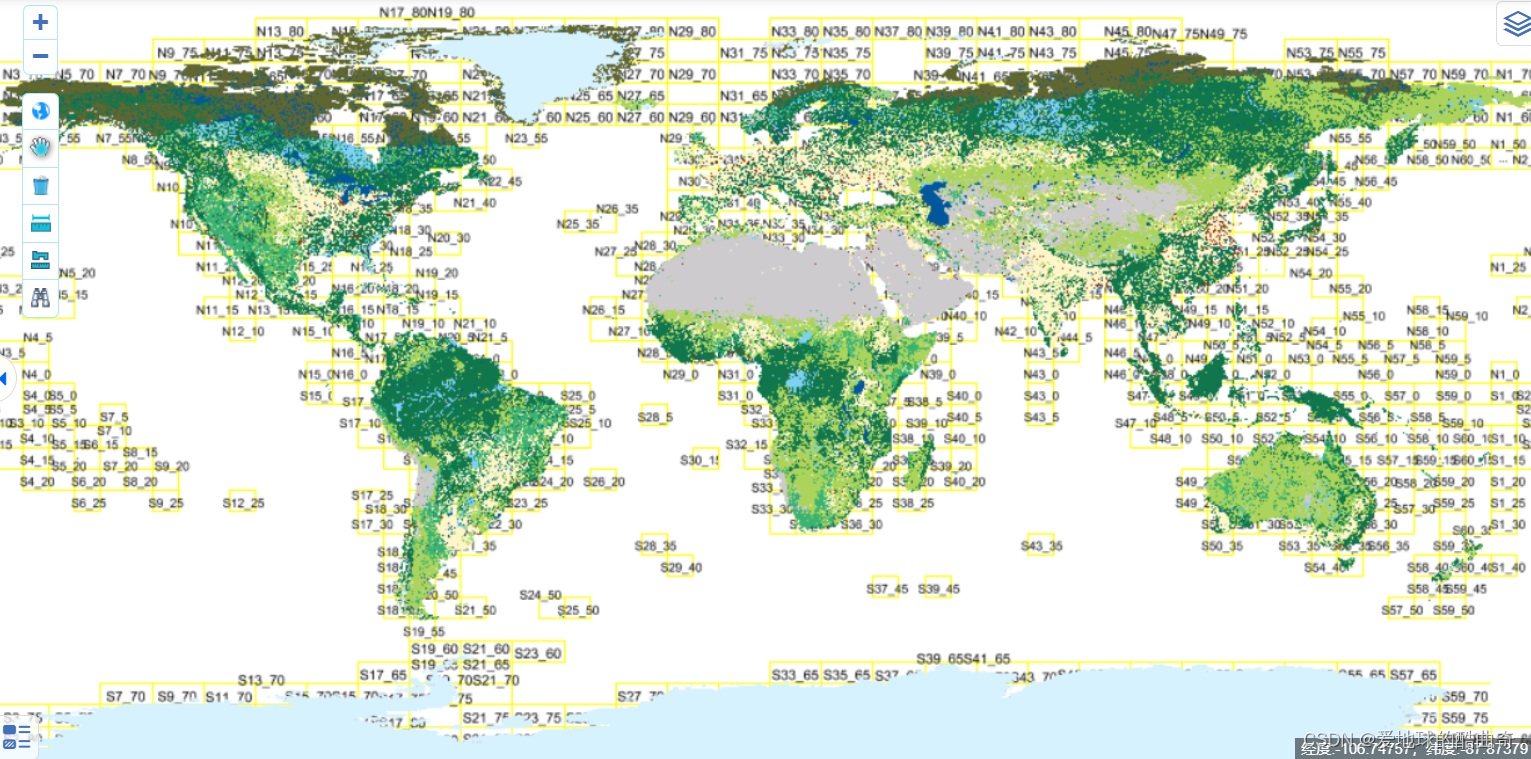
获取途径:Welcome-GlobeLand30http://www.globallandcover.com/![]() http://www.globallandcover.com/
http://www.globallandcover.com/
可注册申请下载
空间范围:全球
时间范围:2000、2010、2020
分辨率:30m
坐标系:GCS_WGS_1984
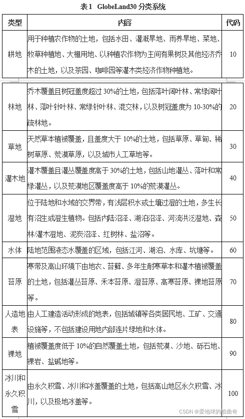
分类方式:分类系统如下图所示:
若遇下载或拼接处理困难,可参考以下链接,以中国区域为例对拼接处理方法进行了讲解。
GlobeLand30土地利用数据中国区域拼接完成版2020_土地利用数据-专业指导文档类资源-CSDN下载
2. 清华数据库(FROM_GLC)
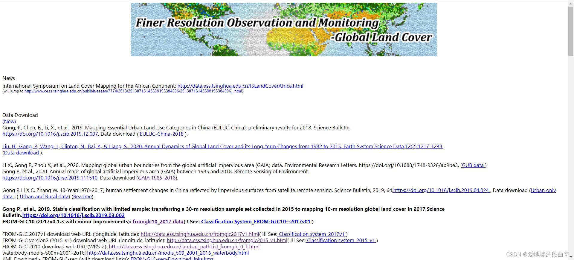
个人非常喜欢的数据库,清华大学宫鹏老师课题组的成果,全部都是开源免费下载。
里面包括2017年10m分辨率全球土地利用数据、2015/2017年30m分辨率全球土地利用数据、全球不透水面数据(GAIA)、我国城市土地利用类型(EULUC_China)等免费下载。
空间范围:中国、全球
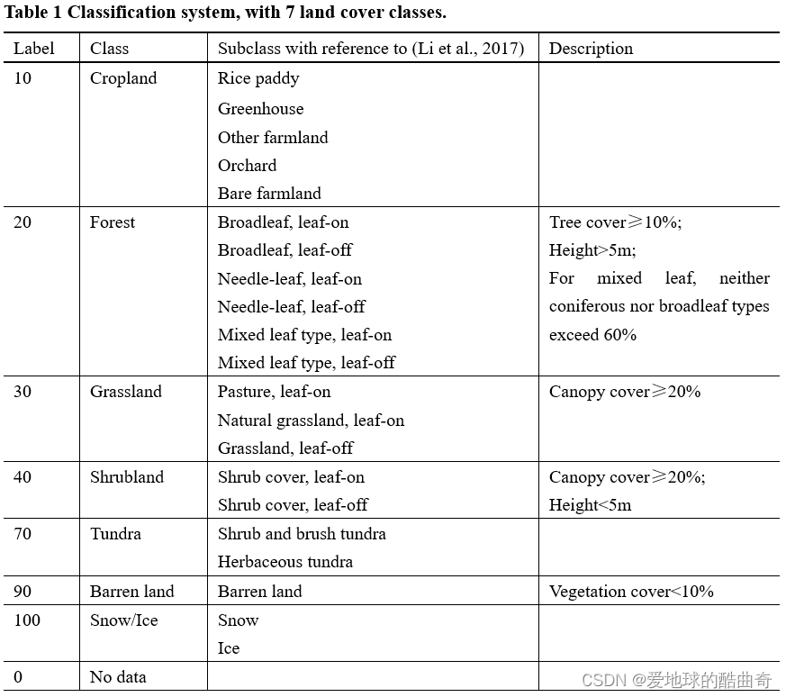
2017年数据的分类系统如下图所示:

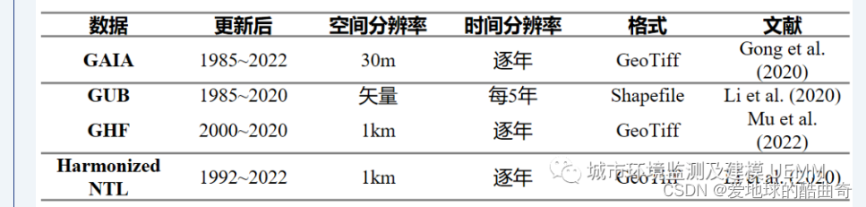
2023/06/09补充:中国农业大学土地科学与技术学院李雪草教授团队将宫鹏老师的成果在时间上继续更新了:团队成果|全球逐年不透水面、城市边界等数据集更新说明
2025/03/24更新:迁移了新的网址
iEarth DataHub![]() https://data-starcloud.pcl.ac.cn/iearthdata/
https://data-starcloud.pcl.ac.cn/iearthdata/
3. MODIS数据
MODIS数据提供了全球2001-2019每年500m分辨率的数据,提供了五种不同的分类方式,IGBP、马里兰大学、生物地理群落、植被类型等,可以根据自己的用途进行选择。
注册登录即免费下载
空间范围:全球
时间范围:2001-2019
分辨率:500m
坐标系:GCS_WGS_1984
4. 欧空局300m数据
获取途径:
注册登录即免费下载
空间范围:全球
时间范围:1992-2020
分辨率:300m
坐标系:GCS_WGS_1984
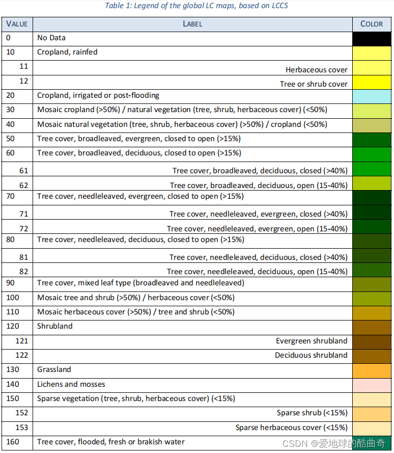
描述:1992-2020年连续数据,分类如下:
若遇下载困难,可以参考以下链接一键下载:
1992-2020欧盟300m全球土地利用数据_300m土地利用数据-咨询文档类资源-CSDN下载
5. GLASS-GLC
1982-2015全球土地覆盖变化数据
数据是开源免费下载
空间范围:全球
时间范围:1982-2015
分辨率:5km
坐标系:GCS_WGS_1984
描述:时间范围是连续的34年,只是分辨率较低,分类系统如下图所示:
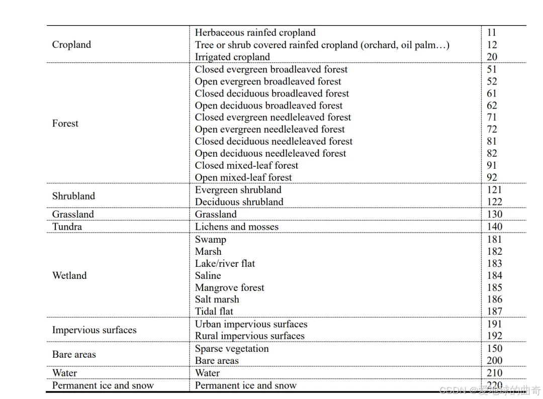
6. GLC_FCS30_2020
中国科学院空天信息创新研究院刘良云研究员团队对外发布的2020年全球30米地表覆盖精细分类产品
获取途径:
空间范围:全球
时间范围:2020
分辨率:30m
坐标系:GCS_WGS_1984
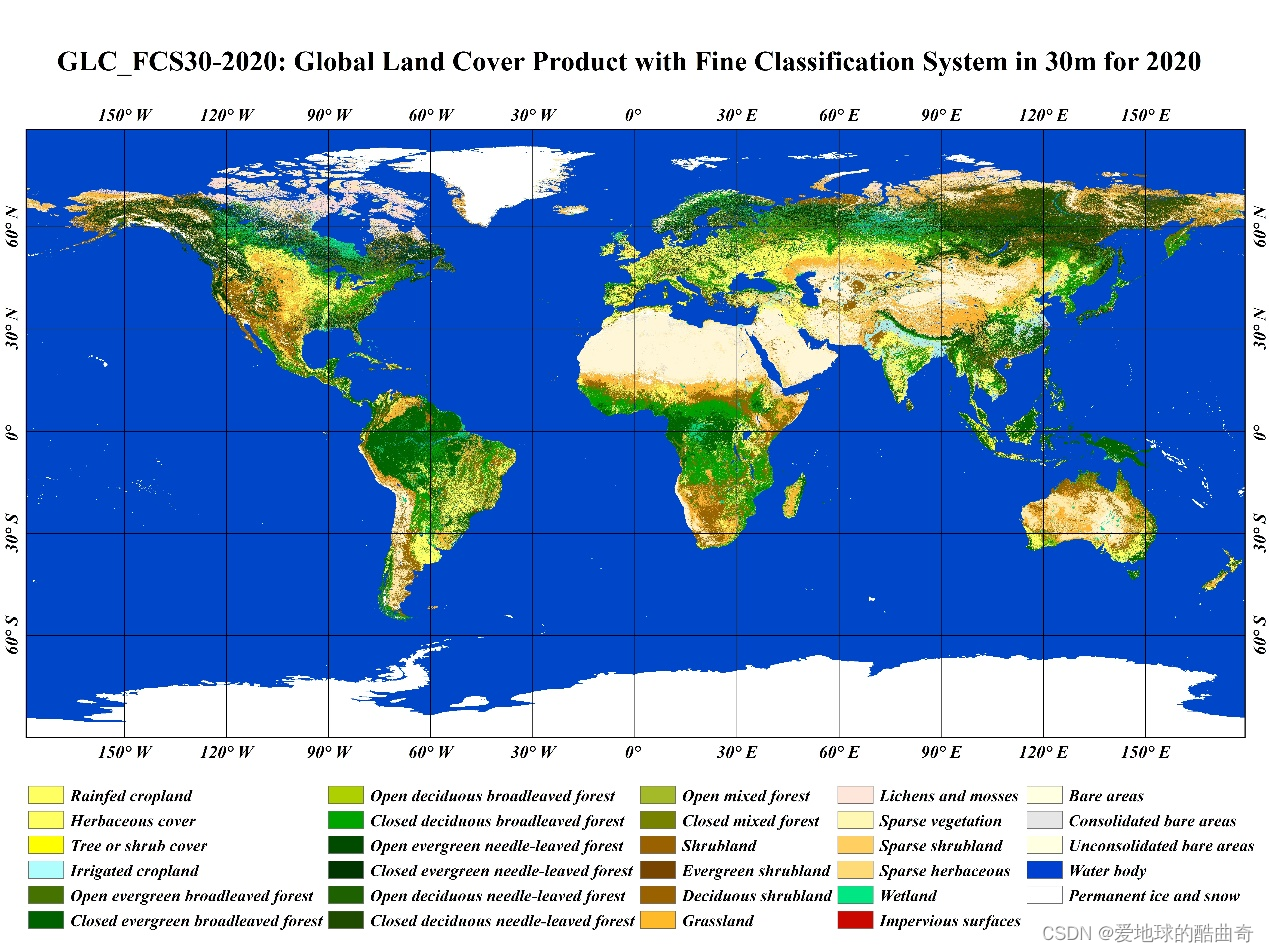
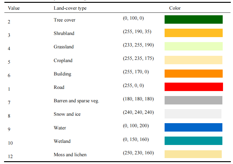
描述:GLC_FCS30-2020产品是在2015年全球30米土地覆盖产品精细分类系统(GLC_FCS30-2015)的基础上,结合2019-2020年时间序列Landsat地表反射率数据、Sentinel-1 SAR数据、DEM地形高程数据、全球专题辅助数据集和先验知识数据集制作而成。
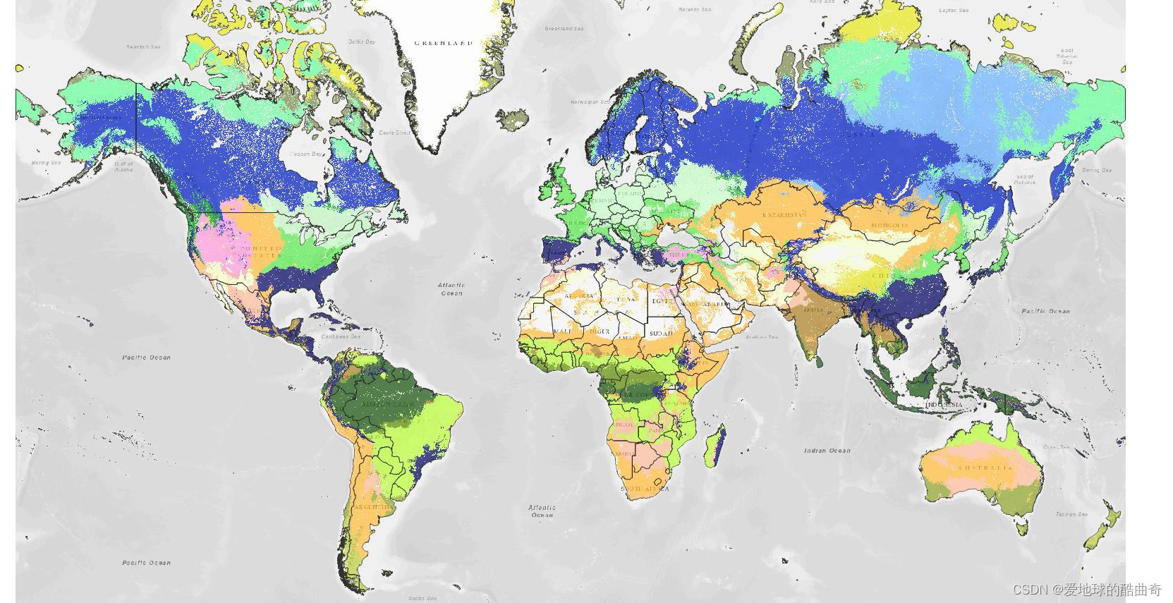
全球图片与分类系统如下图所示:
2015年数据可从以下链接获取:
2025/02/10更新:
该数据采用了包含35个土地覆盖类别的细化分类系统,时间跨度为1985年至2022年,年份分别为:1985年、1990年、1995年、2000年、2005年、2010年、2015年、2020年、2021年和2022年。2000年之前,更新周期为每5年更新一次,2000年之后,每年更新一次。
看样子作者会不定期更新。
该数据结合了密集时间序列 Landsat 影像的连续变化检测方法、局部自适应更新模型和时空优化算法,并经过验证,利用 LCCS 1 级验证系统中的17 个土地覆盖进行验证的精度为73.24% (±0.30%),10 个主要土地覆盖类型总体准确率达到 **80.88%**(±0.27%)。
7. PNV潜在植被覆盖与群落类型
一个研究分享的数据,基于机器学习算法对全球潜在自然植被进行评估,数据开源可免费下载。
时间范围:-
分辨率:1km/250m
坐标系:GCS_WGS_1984
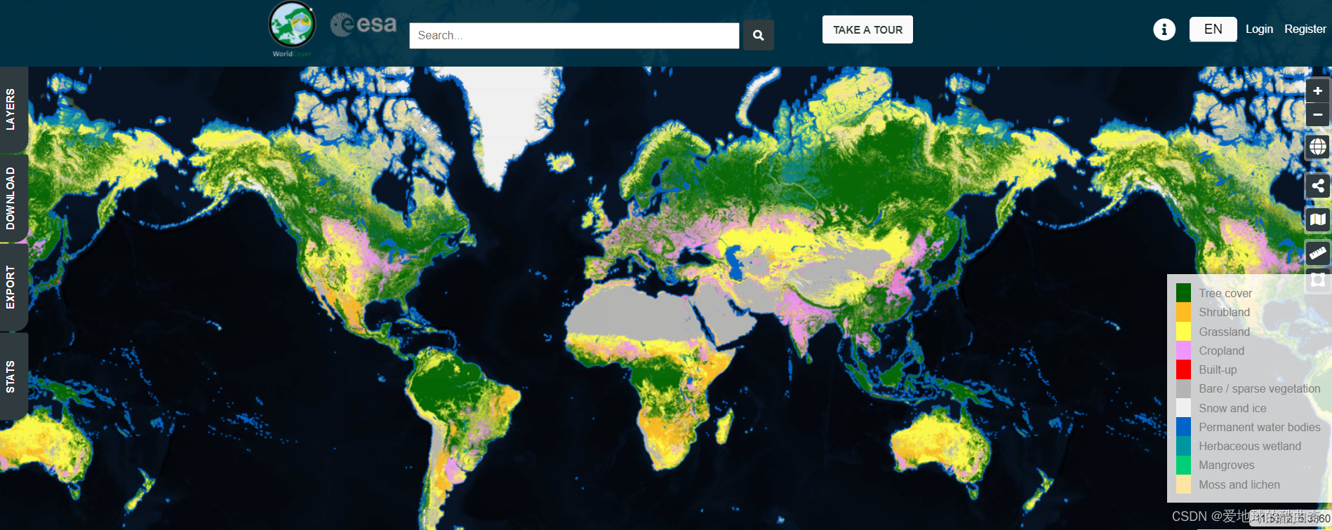
8. 欧空局ESA10m分辨率土地利用数据
欧洲航天局(ESA)的WorldCover 10m 2020产品是基于Sentinel-1和Sentinel-2制作,以10米的分辨率提供了2020年的全球土地覆盖图。WorldCover产品有11个土地覆盖类别,与联合国粮农组织的土地覆盖分类系统相一致,并在欧空局WorldCover项目框架内生成。该产品的总体精度为74%。数据开放下载。
在用户的积极反馈之后,欧空局决定继续开展WorldCover项目,并要求项目组也生产出更高质量的新产品2021版本。2021年全球土地覆被数据于2022年10月28日发布,全球整体准确率为 76.7%。
获取方式:
https://viewer.esa-worldcover.org/worldcover
ESA WorldCover 10 m 2020 v100 | Zenodo
ESA WorldCover 10 m 2021 v200 | Zenodo
9. ESRI 10m数据
ESRI提供的10m分辨率数据,数据基于Sentinel-2制作,全球范围,WGS84坐标,提供2017、 2018、2019、2020、2021、2022连续年份的土地利用数据。可从以下链接尝试下载。
https://www.arcgis.com/home/item.html?id=cfcb7609de5f478eb7666240902d4d3d
10. CLCD数据
由武汉大学开发,免费下载,网上有人下载下来再上传赚钱的,这个下载实在是不用什么技术含量,请大家注意甄别!
时间范围:1990-2021
分辨率:30m
坐标系:GCS_WGS_1984/GCS_WGS_1984_Albers
分类系统:
2025/02/10更新:最新更新到2023年了,看样子作者会每一年更新上一年的,可以保持关注!
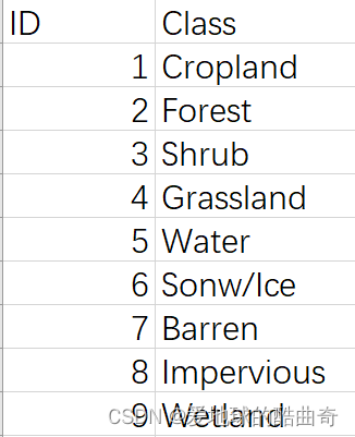
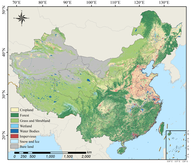
11. 2020年全国10m分辨率地表覆盖数据集
武汉大学提出了一种基于样本噪声学习的跨分辨率土地覆盖制图框架,利用现有低分辨率产品生成大量高分辨率影像标签用于深度语义分割模型的训练,实现2020年全国10米分辨率土地覆盖高效制图。包含耕地、林地、草地/灌木、湿地、水体、不透水面、裸地和冰雪8个类别,经过精度评估总体精度达到84%。
提出了一种基于深度标签噪声学习的跨分辨率地表覆盖制图方法CRLC(Cross-Resolution Land-Cover mapping framework based on noisy label learning),主要包括以下三个步骤:
(1)数据准备:搜集2020年份所有可获取的哨兵2号10米分辨率数据,合成全国年度无云影像;
(2)样本生成:利用历史产品生成样本,并利用条件随机场模型(CRF)将历史样本与最新影像对齐,构建超过10亿像素级别的大规模地表覆盖分类训练集;
(3)模型训练:利用数据集训练高分辨率深度语义分割网络(HDNet),通过样本噪声剔除模块实现模型的文件训练。
CRLC产品是按1°×1°的瓦片形式提供的,覆盖全球研究区范围共计1140个图幅。
坐标系统:EPSG:4326(WGS84)地理坐标系统。
命名规则:N_<左下角经度>_<左下角纬度>.tif
类别体系:1.耕地,2.林地,3.草地/灌木,5.湿地,6.水体,8.不透水面,9.裸地,10.冰雪。
引用格式:
Liu,Y., Zhong,Y.,Ma,A.,Zhao,J.and Zhang,L., 2023.Cross-resolution national-scale land-cover mapping based on noisy label learning: A case study of China. International Journal of Applied Earth Observation and Geoinformation, 118, p.103265.
原文链接:
https://doi.org/10.1016/j.jag.2023.103265
数据链接:
https://github.com/LiuGalaxy/CRLC
团队官网:
http://rsidea.whu.edu.cn/resource_sharing.htm
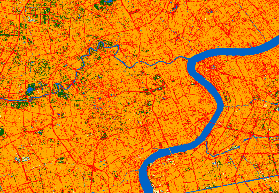
12. 全国各城市的1米分辨率的土地覆盖数据
武汉大学李卓鸿、何伟等研究者基于深度学习框架和开放数据,具体包括全球土地覆盖(GLC)数据、OSM地图数据、谷歌地球图像,建立了我国首套1米分辨率土地覆盖图(SinoLC-1),该数据格式为GeoTIFF格式,坐标为wgs1984,数据以城市为分割,每个城市一个文件。该数据仍在持续更新中,请继续关注。
数据细节:
分类方式:
引用方式:
Li, Z., He, W., Cheng, M., Hu, J., Yang, G., and Zhang, H.: SinoLC-1: the first 1-meter resolution national-scale land-cover map of China created with the deep learning framework and open-access data, Earth Syst. Sci. Data Discuss. [preprint], https://doi.org/10.5194/essd-2023-87, in review, 2023.
下载链接:
13. 2020年全球30米湿地数据产品(GWL_FCS30)
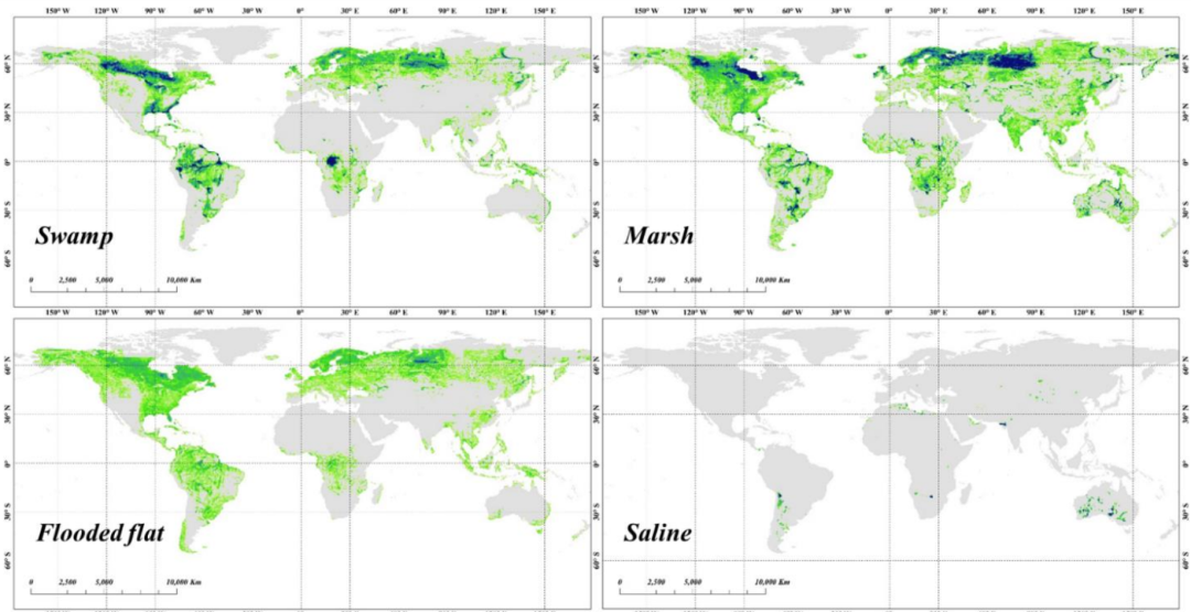
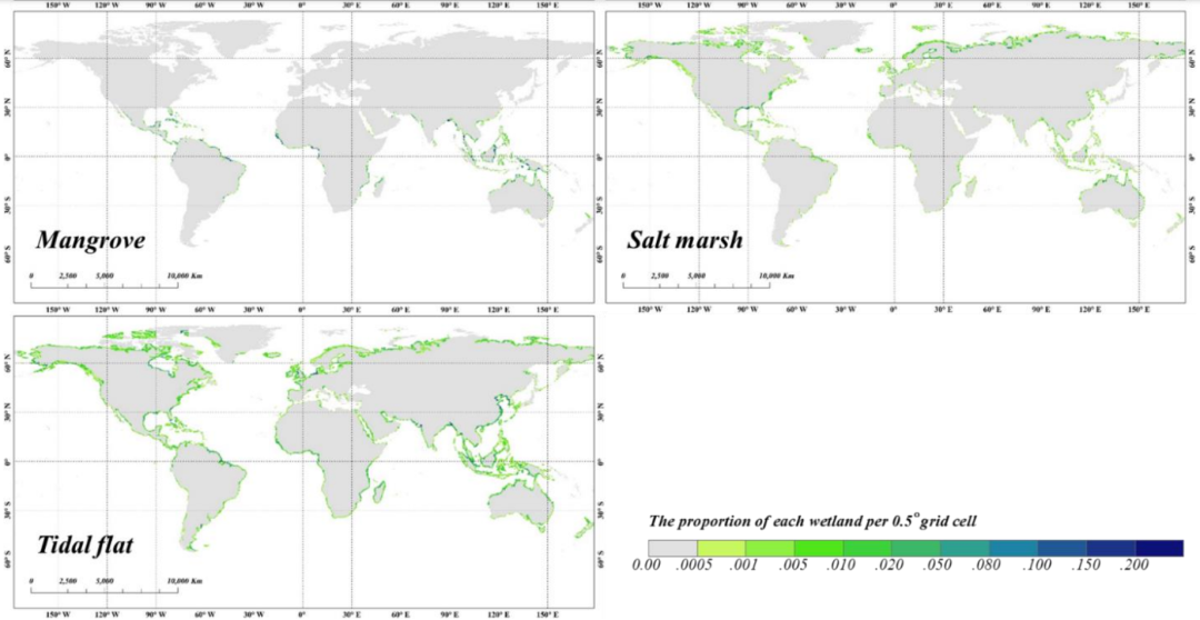
该套数据结合GEE平台提出了一种结合自动样本提取方法、多源现有产品、时间序列卫星图像和分层分类策略的湿地制图新方法。该数据集是第一个具有精细分类系统 (GWL_FCS30)的全球30米湿地地图,包括四个内陆湿地子类别(沼泽、沼泽、泛滥平原和盐碱地)和三个沿海湿地子类别(红树林、盐沼和潮滩)。
在这项研究中,利用时间序列的Landsat反射率数据产品和Sentinel-1 SAR影像,加上分层分类策略和局部自适应随机森林分类算法,成功地整合出2020年第一个具有精细分类系统的全球30米湿地产品。湿地被分为四种内陆湿地(沼泽、沼泽、水淹平地和盐碱地)和三种沿海湿地(红树林、盐沼和潮汐平地)。
产生的湿地数据集GWL_FCS30准确地分许了七个湿地二级类的空间模式,总体精度为87.7%,精细湿地分类系统的卡帕系数为0.810,与其他全球产品相比误差较低。定量统计分析表明,全球湿地面积达到357万平方公里,包括310万平方公里的内陆湿地和47万平方公里的沿海湿地。大约62.3%的湿地分布在北纬40度的极地。
数据方法:
1.首先将现有的多源全球湿地产品、专家知识、训练样本细化规则和视觉解读结合起来,生成了大量的、地理分布的湿地训练样本。
2.其次通过整合了时间序列的Landsat反射率产品和Sentinel-1 SAR图像,生成水位和物候信息,以捕捉湿地的复杂时间动态和光谱异质性。
3.接着应用分层分类策略和局部自适应随机森林分类模型,在2020年每个5°×5°的地理瓦片上产生具有精细分类系统的湿地数据集。
4.最后利用18,701个验证样本对由961张5°×5°区域湿地地图镶嵌的GWL_FCS30进行了验证,其总体准确率达到87.7%,Kappa系数为0.810。
引用方式:
Zhang,X.,Liu,L.,Zhao,T.,Chen,X.,Lin,S.,Wang,J.,Mi,J.,and Liu,W.:GWL_FCS30:global 30 m wetland map with fine classification system using multi-sourced and time-series remote sensing imagery in 2020, Earth Syst. Sci. Data Discuss.[preprint],https://doi.org/10.5194/essd-2022-180,in review,2022.
下载链接:
GWL_FCS30: global 30 m wetland map with fine classification system in 2020 | Zenodo
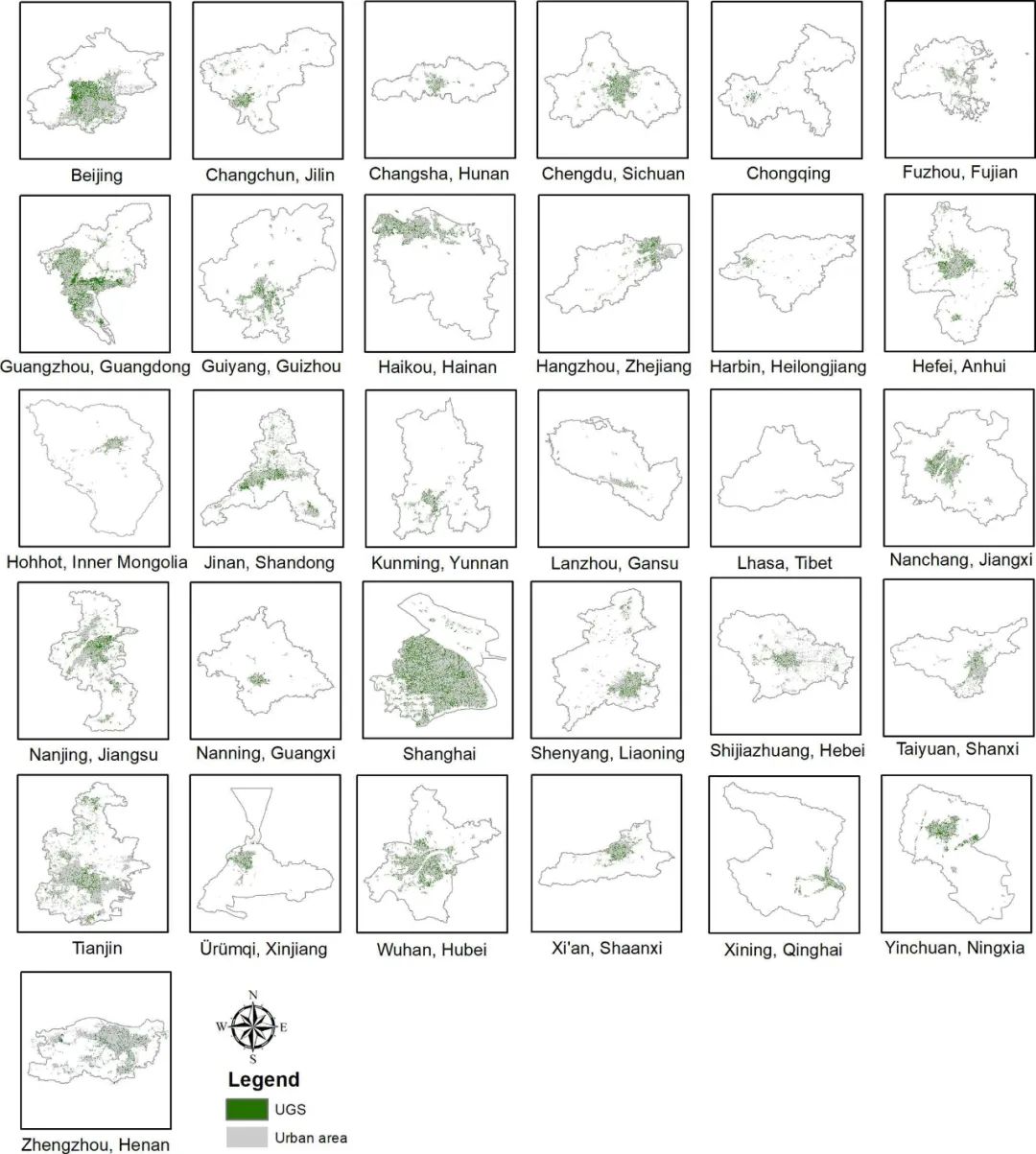
14. 中国31个主要城市细粒度城市绿地数据集
UGS-1m产品提供了中国31个主要城市的细粒度UGS地图,该地图是基于深度学习框架,利用GoogleEarth影像生成的。研究区域包括北京、上海、天津和重庆,呼和浩特、南宁、拉萨、银川和乌鲁木齐,以及哈尔滨、长春、沈阳、石家庄、兰州、西宁、西安、郑州、济南、长沙、武汉、南京、成都、贵阳、昆明、杭州、南昌、广州、福州和海口。
UGSet和UGSet的代码可在以下网址获得
https://liumency.github.io/UGS-1m/
文章地址:
https://essd.copernicus.org/articles/15/555/2023/
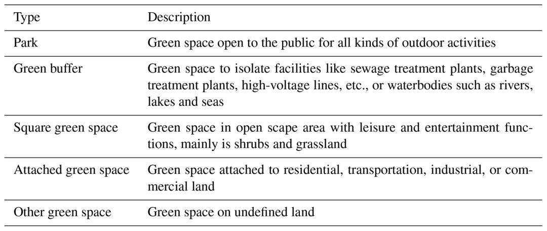
数据集描述:
1) UGS-1m.zip:中国31个主要城市UGS地图产品
2) UGSet.zip:支撑UGS研究的基准数据集
3) GUB_Data.zip:每个城市的城市建成区边界数据
4) GE_Imagery_DataFrame.zip: shp格式的Google Earth图像网格数据
5) 其他以城市名称命名的Zip文件:各城市的Google Earth图片
引用方式:
Shi, Q., Liu, M., Marinoni, A., and Liu, X.: UGS-1m: fine-grained urban green space mapping of 31 major cities in China based on the deep learning framework, Earth Syst. Sci. Data, 15, 555–577, https://doi.org/10.5194/essd-15-555-2023, 2023.
下载链接:
https://www.scidb.cn/en/detail?dataSetId=36af2aed281e4c82aa8a3cd3f1211a37
15. GLC_FCS10
感觉是数据6的升级版,中科院空天院刘良云团队成果,仍然致力于提供30个细分类别的土地覆盖产品,但在分辨率上进一步提升。
多源数据融合:
利用Sentinel-2多时相光学影像与Sentinel-1 SAR数据进行组合。论文采用百分位数统计方法(取10%、30%、50%、70%和90%的分位值)构建时序光谱特征,同时提取NDVI、NDWI、LSWI等指数和纹理特征,以捕捉地表的时相变化与空间结构。
同时,考虑地形变量(如坡度、海拔和坡向)的辅助作用,进一步提升对特定地表类型(例如冰雪、耕地)的区分能力。
分类方式:
数据精度:
论文利用全球共56121个验证样本及第三方LCMAP验证数据对产品进行了全面评估,全球总体精度达到83.16%,Kappa系数为0.789;在美国区域,整体精度提升至85.09%,对于水体、冰雪、不透水面和耕地等具有明显光谱特征的类别,用户精度和制图者精度均超过90%。部分类别如灌丛、草地、裸地以及湿地之间存在较明显混淆。湿地尤其受到水体、森林和草地的干扰,部分子类(例如沼泽与草地)的识别准确度偏低。与ESA WorldCover、ESRI LC以及其他10米或30米产品相比,GLC_FCS10在耕地、森林及湿地等类别上表现更优,尤其在湿地细分上,F1分数明显高于其他产品,充分证明了分层分类和多源数据融合的优势。
引用方式:
Zhang, X., Liu, L., Zhao, T., Zhang, W., Guan, L., Bai, M., and Chen, X.: GLC_FCS10: a global 10-m land-cover dataset with a fine classification system from Sentinel-1 and Sentinel-2 time-series data in Google Earth Engine, Earth Syst. Sci. Data Discuss. [preprint], https://doi.org/10.5194/essd-2025-73, in review, 2025.
数据下载地址:
16. 中国大豆种植区域产品
区域:中国14个主要的大豆生产省份
时间范围:2017-2021年逐年
分辨率:10m
数据源:Sentinel-2遥感影像
图片示例:
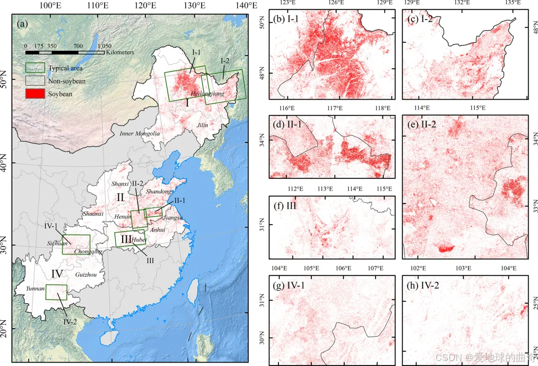
下载地址:
Mei, Q., Zhang, Z., Han, J., Song, J., Dong, J., Wu, H., Xu, J., and Tao, F.: ChinaSoyArea10m: a dataset of soybean-planting areas with a spatial resolution of 10 m across China from 2017 to 2021, Earth Syst. Sci. Data, 16, 3213–3231, https://doi.org/10.5194/essd-16-3213-2024, 2024.


 905
905

 被折叠的 条评论
为什么被折叠?
被折叠的 条评论
为什么被折叠?
 到【灌水乐园】发言


