


/* -*-c++-*- */
/* osgEarth - Dynamic map generation toolkit for OpenSceneGraph
* Copyright 2008-2014 Pelican Mapping
* http://osgearth.org
*
* osgEarth is free software; you can redistribute it and/or modify
* it under the terms of the GNU Lesser General Public License as published by
* the Free Software Foundation; either version 2 of the License, or
* (at your option) any later version.
*
* This program is distributed in the hope that it will be useful,
* but WITHOUT ANY WARRANTY; without even the implied warranty of
* MERCHANTABILITY or FITNESS FOR A PARTICULAR PURPOSE. See the
* GNU Lesser General Public License for more details.
*
* You should have received a copy of the GNU Lesser General Public License
* along with this program. If not, see <http://www.gnu.org/licenses/>
*/
#include <string>
#include <osg/Notify>
#include <osg/Timer>
#include <osg/ShapeDrawable>
#include <osg/PositionAttitudeTransform>
#include <osgGA/StateSetManipulator>
#include <osgGA/GUIEventHandler>
#include <osgViewer/Viewer>
#include <osgViewer/ViewerEventHandlers>
#include <osgEarth/GeoMath>
#include <osgEarth/GeoTransform>
#include <osgEarth/MapNode>
#include <osgEarth/TerrainEngineNode>
#include <osgEarth/Viewpoint>
#include <osgEarthUtil/EarthManipulator>
#include <osgEarthUtil/AutoClipPlaneHandler>
#include <osgEarthUtil/Controls>
#include <osgEarthUtil/ExampleResources>
#include <osgEarthAnnotation/AnnotationUtils>
#include <osgEarthAnnotation/LabelNode>
#include <osgEarthSymbology/Style>
using namespace osgEarth::Util;
using namespace osgEarth::Util::Controls;
using namespace osgEarth::Annotation;
#define D2R (osg::PI/180.0)
#define R2D (180.0/osg::PI)
namespace
{
/**
* Builds our help menu UI.
*/
Control* createHelp( osgViewer::View* view )
{
const char* text[] =
{
"left mouse :", "pan",
"middle mouse :", "rotate",
"right mouse :", "continuous zoom",
"double-click :", "zoom to point",
"scroll wheel :", "zoom in/out",
"arrows :", "pan",
"1-6 :", "fly to preset viewpoints",
"shift-right-mouse :", "locked panning",
"u :", "toggle azimuth lock",
"c :", "toggle perspective/ortho",
"t :", "toggle tethering",
"a :", "toggle viewpoint arcing",
"z :", "toggle throwing"
};
Grid* g = new Grid();
for( unsigned i=0; i<sizeof(text)/sizeof(text[0]); ++i )
{
unsigned c = i % 2;
unsigned r = i / 2;
g->setControl( c, r, new LabelControl(text[i]) );
}
VBox* v = new VBox();
v->addControl( g );
return v;
}
/**
* Some preset viewpoints to show off the setViewpoint function.
*/
static Viewpoint VPs[] = {
Viewpoint( "Africa", osg::Vec3d( 0.0, 0.0, 0.0 ), 0.0, -90.0, 10e6 ),
Viewpoint( "California", osg::Vec3d( -121.0, 34.0, 0.0 ), 0.0, -90.0, 6e6 ),
Viewpoint( "Europe", osg::Vec3d( 0.0, 45.0, 0.0 ), 0.0, -90.0, 4e6 ),
Viewpoint( "Washington DC", osg::Vec3d( -77.0, 38.0, 0.0 ), 0.0, -90.0, 1e6 ),
Viewpoint( "Australia", osg::Vec3d( 135.0, -20.0, 0.0 ), 0.0, -90.0, 2e6 ),
Viewpoint( "Boston", osg::Vec3d( -71.096936, 42.332771, 0 ), 0.0, -90, 1e5 )
};
/**
* Handler that demonstrates the "viewpoint" functionality in
* osgEarthUtil::EarthManipulator. Press a number key to fly to a viewpoint.
*/
struct FlyToViewpointHandler : public osgGA::GUIEventHandler
{
FlyToViewpointHandler( EarthManipulator* manip ) : _manip(manip) { }
bool handle( const osgGA::GUIEventAdapter& ea, osgGA::GUIActionAdapter& aa )
{
if ( ea.getEventType() == ea.KEYDOWN && ea.getKey() >= '1' && ea.getKey() <= '6' )
{
_manip->setViewpoint( VPs[ea.getKey()-'1'], 4.0 );
aa.requestRedraw();
}
return false;
}
osg::observer_ptr<EarthManipulator> _manip;
};
/**
* Handler to toggle "azimuth locking", which locks the camera's relative Azimuth
* while panning. For example, it can maintain "north-up" as you pan around. The
* caveat is that when azimuth is locked you cannot cross the poles.
*/
struct LockAzimuthHandler : public osgGA::GUIEventHandler
{
LockAzimuthHandler(char key, EarthManipulator* manip)
: _key(key), _manip(manip) { }
bool handle(const osgGA::GUIEventAdapter& ea, osgGA::GUIActionAdapter& aa)
{
if (ea.getEventType() == ea.KEYDOWN && ea.getKey() == _key)
{
bool lockAzimuth = _manip->getSettings()->getLockAzimuthWhilePanning();
_manip->getSettings()->setLockAzimuthWhilePanning(!lockAzimuth);
aa.requestRedraw();
return true;
}
return false;
}
void getUsage(osg::ApplicationUsage& usage) const
{
using namespace std;
usage.addKeyboardMouseBinding(string(1, _key), string("Toggle azimuth locking"));
}
char _key;
osg::ref_ptr<EarthManipulator> _manip;
};
/**
* Handler to toggle "viewpoint transtion arcing", which causes the camera to "arc"
* as it travels from one viewpoint to another.
*/
struct ToggleArcViewpointTransitionsHandler : public osgGA::GUIEventHandler
{
ToggleArcViewpointTransitionsHandler(char key, EarthManipulator* manip)
: _key(key), _manip(manip) { }
bool handle(const osgGA::GUIEventAdapter& ea, osgGA::GUIActionAdapter& aa)
{
if (ea.getEventType() == ea.KEYDOWN && ea.getKey() == _key)
{
bool arc = _manip->getSettings()->getArcViewpointTransitions();
_manip->getSettings()->setArcViewpointTransitions(!arc);
aa.requestRedraw();
return true;
}
return false;
}
void getUsage(osg::ApplicationUsage& usage) const
{
using namespace std;
usage.addKeyboardMouseBinding(string(1, _key), string("Arc viewpoint transitions"));
}
char _key;
osg::ref_ptr<EarthManipulator> _manip;
};
/**
* Toggles the projection matrix between perspective and orthographic.
*/
struct ToggleProjectionHandler : public osgGA::GUIEventHandler
{
ToggleProjectionHandler(char key, EarthManipulator* manip)
: _key(key), _manip(manip)
{
}
bool handle(const osgGA::GUIEventAdapter& ea, osgGA::GUIActionAdapter& aa)
{
if (ea.getEventType() == ea.KEYDOWN && ea.getKey() == _key)
{
if ( _manip->getSettings()->getCameraProjection() == EarthManipulator::PROJ_PERSPECTIVE )
_manip->getSettings()->setCameraProjection( EarthManipulator::PROJ_ORTHOGRAPHIC );
else
_manip->getSettings()->setCameraProjection( EarthManipulator::PROJ_PERSPECTIVE );
aa.requestRedraw();
return true;
}
return false;
}
void getUsage(osg::ApplicationUsage& usage) const
{
using namespace std;
usage.addKeyboardMouseBinding(string(1, _key), string("Toggle projection type"));
}
char _key;
osg::ref_ptr<EarthManipulator> _manip;
};
/**
* Toggles the throwing feature.
*/
struct ToggleThrowingHandler : public osgGA::GUIEventHandler
{
ToggleThrowingHandler(char key, EarthManipulator* manip)
: _key(key), _manip(manip)
{
}
bool handle(const osgGA::GUIEventAdapter& ea, osgGA::GUIActionAdapter& aa)
{
if (ea.getEventType() == ea.KEYDOWN && ea.getKey() == _key)
{
bool throwing = _manip->getSettings()->getThrowingEnabled();
_manip->getSettings()->setThrowingEnabled( !throwing );
aa.requestRedraw();
return true;
}
return false;
}
void getUsage(osg::ApplicationUsage& usage) const
{
using namespace std;
usage.addKeyboardMouseBinding(string(1, _key), string("Toggle throwing"));
}
char _key;
osg::ref_ptr<EarthManipulator> _manip;
};
/**
* A simple simulator that moves an object around the Earth. We use this to
* demonstrate/test tethering.
{
Simulator( osg::Group* root, EarthManipulator* manip, MapNode* mapnode, osg::Node* model)
: _manip(manip), _mapnode(mapnode), _model(model), _lat0(-2), _lon0(35), _lat1(0), _lon1(41)
{
if ( !model )
{
_model = AnnotationUtils::createSphere( 250.0, osg::Vec4(1,.7,.4,1) );
}
//_xform得到地形自身坐标系,可直接使用经纬度
_xform = new GeoTransform();
_xform->setTerrain(mapnode->getTerrain());
//_pat通过位置和四元数设置一个坐标转换
_pat = new osg::PositionAttitudeTransform();
_pat->addChild( _model );
_xform->addChild( _pat );
_cam = new osg::Camera();
_cam->setRenderOrder( osg::Camera::NESTED_RENDER, 1 );
_cam->addChild( _xform );
Style style;
style.getOrCreate<TextSymbol>()->size() = 32.0f;
style.getOrCreate<TextSymbol>()->declutter() = false;
_label = new LabelNode(_mapnode, GeoPoint(), "Hello World", style);
_label->setDynamic( true );
_cam->addChild( _label );
root->addChild( _cam.get() );
}
bool handle(const osgGA::GUIEventAdapter& ea, osgGA::GUIActionAdapter& aa)
{
if ( ea.getEventType() == ea.FRAME )
{
//fmod(x,y)函数——求x/y的余数
double t = fmod( osg::Timer::instance()->time_s(), 600.0 ) / 600.0;
double lat, lon;
//interpolate起始点到最终点做插值运算,输出经纬度
GeoMath::interpolate( D2R*_lat0, D2R*_lon0, D2R*_lat1, D2R*_lon1, t, lat, lon );
GeoPoint p( SpatialReference::create("wgs84"), R2D*lon, R2D*lat, 2500.0 );
//bearing计算当前点到下一点的方位角角度
double bearing = GeoMath::bearing( lat,lon,D2R*_lat1,D2R*_lon1);
_xform->setPosition( p );
//设置_pat的姿态
_pat->setAttitude(osg::Quat(3.14-bearing, osg::Vec3d(0,0,1)));
_label->setPosition( p );
}
else if ( ea.getEventType() == ea.KEYDOWN && ea.getKey() == 't' )
{
_manip->getSettings()->setTetherMode(osgEarth::Util::EarthManipulator:: TETHER_CENTER );
//设置_manip的绑定节点
_manip->setTetherNode( _manip->getTetherNode() ? 0L : _xform.get(), 2.0 );
Viewpoint vp = _manip->getViewpoint();
vp.setRange(5000);
//设置操作器的视点
_manip->setViewpoint(vp);
return true;
}
return false;
}
MapNode* _mapnode;
EarthManipulator* _manip;
osg::ref_ptr<osg::Camera> _cam;
osg::ref_ptr<GeoTransform> _xform;
osg::ref_ptr<osg::PositionAttitudeTransform> _pat;
double _lat0, _lon0, _lat1, _lon1;
LabelNode* _label;
osg::Node* _model;
};
}
int main(int argc, char** argv)
{
osg::ArgumentParser arguments(&argc,argv);
if (arguments.read("--help") || argc==1)
{
OE_WARN << "Usage: " << argv[0] << " [earthFile] [--model modelToLoad]"
<< std::endl;
return 0;
}
osgViewer::Viewer viewer(arguments);
// install the programmable manipulator.
EarthManipulator* manip = new EarthManipulator();
viewer.setCameraManipulator( manip );
// UI:
Control* help = createHelp(&viewer);
osg::Node* earthNode = MapNodeHelper().load( arguments, &viewer, help );
if (!earthNode)
{
OE_WARN << "Unable to load earth model." << std::endl;
return -1;
}
osg::Group* root = new osg::Group();
root->addChild( earthNode );
//确定初始视口
osgEarth::MapNode* mapNode = osgEarth::MapNode::findMapNode( earthNode );
if ( mapNode )
{
if ( mapNode )
manip->setNode( mapNode->getTerrainEngine() );//把操作器绑定至节点
if ( mapNode->getMap()->isGeocentric() )
{
manip->setHomeViewpoint(
Viewpoint( osg::Vec3d( -90, 0, 0 ), 0.0, -90.0, 5e7 ) );
}
}
// user model?
osg::Node* model = 0L;
std::string modelFile;
if (arguments.read("--model", modelFile))
model = osgDB::readNodeFile(modelFile);
// Simulator for tethering:
viewer.addEventHandler( new Simulator(root, manip, mapNode, model) );
manip->getSettings()->getBreakTetherActions().push_back( EarthManipulator::ACTION_PAN );
manip->getSettings()->getBreakTetherActions().push_back( EarthManipulator::ACTION_GOTO );
viewer.setSceneData( root );
manip->getSettings()->bindMouse(
EarthManipulator::ACTION_EARTH_DRAG,
osgGA::GUIEventAdapter::LEFT_MOUSE_BUTTON,
osgGA::GUIEventAdapter::MODKEY_SHIFT );
manip->getSettings()->setArcViewpointTransitions( true );
viewer.addEventHandler(new FlyToViewpointHandler( manip ));
viewer.addEventHandler(new LockAzimuthHandler('u', manip));
viewer.addEventHandler(new ToggleProjectionHandler('c', manip));
viewer.addEventHandler(new ToggleArcViewpointTransitionsHandler('a', manip));
viewer.addEventHandler(new ToggleThrowingHandler('z', manip));
while(!viewer.done())
{
viewer.frame();
// simulate slow frame rate
//OpenThreads::Thread::microSleep(1000*1000);
}
return 0;
}
/* osgEarth - Dynamic map generation toolkit for OpenSceneGraph
* Copyright 2008-2014 Pelican Mapping
* http://osgearth.org
*
* osgEarth is free software; you can redistribute it and/or modify
* it under the terms of the GNU Lesser General Public License as published by
* the Free Software Foundation; either version 2 of the License, or
* (at your option) any later version.
*
* This program is distributed in the hope that it will be useful,
* but WITHOUT ANY WARRANTY; without even the implied warranty of
* MERCHANTABILITY or FITNESS FOR A PARTICULAR PURPOSE. See the
* GNU Lesser General Public License for more details.
*
* You should have received a copy of the GNU Lesser General Public License
* along with this program. If not, see <http://www.gnu.org/licenses/>
*/
#include <string>
#include <osg/Notify>
#include <osg/Timer>
#include <osg/ShapeDrawable>
#include <osg/PositionAttitudeTransform>
#include <osgGA/StateSetManipulator>
#include <osgGA/GUIEventHandler>
#include <osgViewer/Viewer>
#include <osgViewer/ViewerEventHandlers>
#include <osgEarth/GeoMath>
#include <osgEarth/GeoTransform>
#include <osgEarth/MapNode>
#include <osgEarth/TerrainEngineNode>
#include <osgEarth/Viewpoint>
#include <osgEarthUtil/EarthManipulator>
#include <osgEarthUtil/AutoClipPlaneHandler>
#include <osgEarthUtil/Controls>
#include <osgEarthUtil/ExampleResources>
#include <osgEarthAnnotation/AnnotationUtils>
#include <osgEarthAnnotation/LabelNode>
#include <osgEarthSymbology/Style>
using namespace osgEarth::Util;
using namespace osgEarth::Util::Controls;
using namespace osgEarth::Annotation;
#define D2R (osg::PI/180.0)
#define R2D (180.0/osg::PI)
namespace
{
/**
* Builds our help menu UI.
*/
Control* createHelp( osgViewer::View* view )
{
const char* text[] =
{
"left mouse :", "pan",
"middle mouse :", "rotate",
"right mouse :", "continuous zoom",
"double-click :", "zoom to point",
"scroll wheel :", "zoom in/out",
"arrows :", "pan",
"1-6 :", "fly to preset viewpoints",
"shift-right-mouse :", "locked panning",
"u :", "toggle azimuth lock",
"c :", "toggle perspective/ortho",
"t :", "toggle tethering",
"a :", "toggle viewpoint arcing",
"z :", "toggle throwing"
};
Grid* g = new Grid();
for( unsigned i=0; i<sizeof(text)/sizeof(text[0]); ++i )
{
unsigned c = i % 2;
unsigned r = i / 2;
g->setControl( c, r, new LabelControl(text[i]) );
}
VBox* v = new VBox();
v->addControl( g );
return v;
}
/**
* Some preset viewpoints to show off the setViewpoint function.
*/
static Viewpoint VPs[] = {
Viewpoint( "Africa", osg::Vec3d( 0.0, 0.0, 0.0 ), 0.0, -90.0, 10e6 ),
Viewpoint( "California", osg::Vec3d( -121.0, 34.0, 0.0 ), 0.0, -90.0, 6e6 ),
Viewpoint( "Europe", osg::Vec3d( 0.0, 45.0, 0.0 ), 0.0, -90.0, 4e6 ),
Viewpoint( "Washington DC", osg::Vec3d( -77.0, 38.0, 0.0 ), 0.0, -90.0, 1e6 ),
Viewpoint( "Australia", osg::Vec3d( 135.0, -20.0, 0.0 ), 0.0, -90.0, 2e6 ),
Viewpoint( "Boston", osg::Vec3d( -71.096936, 42.332771, 0 ), 0.0, -90, 1e5 )
};
/**
* Handler that demonstrates the "viewpoint" functionality in
* osgEarthUtil::EarthManipulator. Press a number key to fly to a viewpoint.
*/
struct FlyToViewpointHandler : public osgGA::GUIEventHandler
{
FlyToViewpointHandler( EarthManipulator* manip ) : _manip(manip) { }
bool handle( const osgGA::GUIEventAdapter& ea, osgGA::GUIActionAdapter& aa )
{
if ( ea.getEventType() == ea.KEYDOWN && ea.getKey() >= '1' && ea.getKey() <= '6' )
{
_manip->setViewpoint( VPs[ea.getKey()-'1'], 4.0 );
aa.requestRedraw();
}
return false;
}
osg::observer_ptr<EarthManipulator> _manip;
};
/**
* Handler to toggle "azimuth locking", which locks the camera's relative Azimuth
* while panning. For example, it can maintain "north-up" as you pan around. The
* caveat is that when azimuth is locked you cannot cross the poles.
*/
struct LockAzimuthHandler : public osgGA::GUIEventHandler
{
LockAzimuthHandler(char key, EarthManipulator* manip)
: _key(key), _manip(manip) { }
bool handle(const osgGA::GUIEventAdapter& ea, osgGA::GUIActionAdapter& aa)
{
if (ea.getEventType() == ea.KEYDOWN && ea.getKey() == _key)
{
bool lockAzimuth = _manip->getSettings()->getLockAzimuthWhilePanning();
_manip->getSettings()->setLockAzimuthWhilePanning(!lockAzimuth);
aa.requestRedraw();
return true;
}
return false;
}
void getUsage(osg::ApplicationUsage& usage) const
{
using namespace std;
usage.addKeyboardMouseBinding(string(1, _key), string("Toggle azimuth locking"));
}
char _key;
osg::ref_ptr<EarthManipulator> _manip;
};
/**
* Handler to toggle "viewpoint transtion arcing", which causes the camera to "arc"
* as it travels from one viewpoint to another.
*/
struct ToggleArcViewpointTransitionsHandler : public osgGA::GUIEventHandler
{
ToggleArcViewpointTransitionsHandler(char key, EarthManipulator* manip)
: _key(key), _manip(manip) { }
bool handle(const osgGA::GUIEventAdapter& ea, osgGA::GUIActionAdapter& aa)
{
if (ea.getEventType() == ea.KEYDOWN && ea.getKey() == _key)
{
bool arc = _manip->getSettings()->getArcViewpointTransitions();
_manip->getSettings()->setArcViewpointTransitions(!arc);
aa.requestRedraw();
return true;
}
return false;
}
void getUsage(osg::ApplicationUsage& usage) const
{
using namespace std;
usage.addKeyboardMouseBinding(string(1, _key), string("Arc viewpoint transitions"));
}
char _key;
osg::ref_ptr<EarthManipulator> _manip;
};
/**
* Toggles the projection matrix between perspective and orthographic.
*/
struct ToggleProjectionHandler : public osgGA::GUIEventHandler
{
ToggleProjectionHandler(char key, EarthManipulator* manip)
: _key(key), _manip(manip)
{
}
bool handle(const osgGA::GUIEventAdapter& ea, osgGA::GUIActionAdapter& aa)
{
if (ea.getEventType() == ea.KEYDOWN && ea.getKey() == _key)
{
if ( _manip->getSettings()->getCameraProjection() == EarthManipulator::PROJ_PERSPECTIVE )
_manip->getSettings()->setCameraProjection( EarthManipulator::PROJ_ORTHOGRAPHIC );
else
_manip->getSettings()->setCameraProjection( EarthManipulator::PROJ_PERSPECTIVE );
aa.requestRedraw();
return true;
}
return false;
}
void getUsage(osg::ApplicationUsage& usage) const
{
using namespace std;
usage.addKeyboardMouseBinding(string(1, _key), string("Toggle projection type"));
}
char _key;
osg::ref_ptr<EarthManipulator> _manip;
};
/**
* Toggles the throwing feature.
*/
struct ToggleThrowingHandler : public osgGA::GUIEventHandler
{
ToggleThrowingHandler(char key, EarthManipulator* manip)
: _key(key), _manip(manip)
{
}
bool handle(const osgGA::GUIEventAdapter& ea, osgGA::GUIActionAdapter& aa)
{
if (ea.getEventType() == ea.KEYDOWN && ea.getKey() == _key)
{
bool throwing = _manip->getSettings()->getThrowingEnabled();
_manip->getSettings()->setThrowingEnabled( !throwing );
aa.requestRedraw();
return true;
}
return false;
}
void getUsage(osg::ApplicationUsage& usage) const
{
using namespace std;
usage.addKeyboardMouseBinding(string(1, _key), string("Toggle throwing"));
}
char _key;
osg::ref_ptr<EarthManipulator> _manip;
};
/**
* A simple simulator that moves an object around the Earth. We use this to
* demonstrate/test tethering.
*/
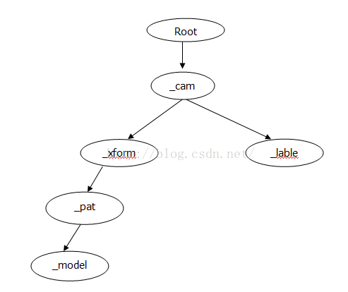
//下面部分结合图片
{
Simulator( osg::Group* root, EarthManipulator* manip, MapNode* mapnode, osg::Node* model)
: _manip(manip), _mapnode(mapnode), _model(model), _lat0(-2), _lon0(35), _lat1(0), _lon1(41)
{
if ( !model )
{
_model = AnnotationUtils::createSphere( 250.0, osg::Vec4(1,.7,.4,1) );
}
//_xform得到地形自身坐标系,可直接使用经纬度
_xform = new GeoTransform();
_xform->setTerrain(mapnode->getTerrain());
//_pat通过位置和四元数设置一个坐标转换
_pat = new osg::PositionAttitudeTransform();
_pat->addChild( _model );
_xform->addChild( _pat );
_cam = new osg::Camera();
_cam->setRenderOrder( osg::Camera::NESTED_RENDER, 1 );
_cam->addChild( _xform );
Style style;
style.getOrCreate<TextSymbol>()->size() = 32.0f;
style.getOrCreate<TextSymbol>()->declutter() = false;
_label = new LabelNode(_mapnode, GeoPoint(), "Hello World", style);
_label->setDynamic( true );
_cam->addChild( _label );
root->addChild( _cam.get() );
}
bool handle(const osgGA::GUIEventAdapter& ea, osgGA::GUIActionAdapter& aa)
{
if ( ea.getEventType() == ea.FRAME )
{
//fmod(x,y)函数——求x/y的余数
double t = fmod( osg::Timer::instance()->time_s(), 600.0 ) / 600.0;
double lat, lon;
//interpolate起始点到最终点做插值运算,输出经纬度
GeoMath::interpolate( D2R*_lat0, D2R*_lon0, D2R*_lat1, D2R*_lon1, t, lat, lon );
GeoPoint p( SpatialReference::create("wgs84"), R2D*lon, R2D*lat, 2500.0 );
//bearing计算当前点到下一点的方位角角度
double bearing = GeoMath::bearing( lat,lon,D2R*_lat1,D2R*_lon1);
_xform->setPosition( p );
//设置_pat的姿态
_pat->setAttitude(osg::Quat(3.14-bearing, osg::Vec3d(0,0,1)));
_label->setPosition( p );
}
else if ( ea.getEventType() == ea.KEYDOWN && ea.getKey() == 't' )
{
_manip->getSettings()->setTetherMode(osgEarth::Util::EarthManipulator:: TETHER_CENTER );
//设置_manip的绑定节点
_manip->setTetherNode( _manip->getTetherNode() ? 0L : _xform.get(), 2.0 );
Viewpoint vp = _manip->getViewpoint();
vp.setRange(5000);
//设置操作器的视点
_manip->setViewpoint(vp);
return true;
}
return false;
}
MapNode* _mapnode;
EarthManipulator* _manip;
osg::ref_ptr<osg::Camera> _cam;
osg::ref_ptr<GeoTransform> _xform;
osg::ref_ptr<osg::PositionAttitudeTransform> _pat;
double _lat0, _lon0, _lat1, _lon1;
LabelNode* _label;
osg::Node* _model;
};
}
int main(int argc, char** argv)
{
osg::ArgumentParser arguments(&argc,argv);
if (arguments.read("--help") || argc==1)
{
OE_WARN << "Usage: " << argv[0] << " [earthFile] [--model modelToLoad]"
<< std::endl;
return 0;
}
osgViewer::Viewer viewer(arguments);
// install the programmable manipulator.
EarthManipulator* manip = new EarthManipulator();
viewer.setCameraManipulator( manip );
// UI:
Control* help = createHelp(&viewer);
osg::Node* earthNode = MapNodeHelper().load( arguments, &viewer, help );
if (!earthNode)
{
OE_WARN << "Unable to load earth model." << std::endl;
return -1;
}
osg::Group* root = new osg::Group();
root->addChild( earthNode );
//确定初始视口
osgEarth::MapNode* mapNode = osgEarth::MapNode::findMapNode( earthNode );
if ( mapNode )
{
if ( mapNode )
manip->setNode( mapNode->getTerrainEngine() );//把操作器绑定至节点
if ( mapNode->getMap()->isGeocentric() )
{
manip->setHomeViewpoint(
Viewpoint( osg::Vec3d( -90, 0, 0 ), 0.0, -90.0, 5e7 ) );
}
}
// user model?
osg::Node* model = 0L;
std::string modelFile;
if (arguments.read("--model", modelFile))
model = osgDB::readNodeFile(modelFile);
// Simulator for tethering:
viewer.addEventHandler( new Simulator(root, manip, mapNode, model) );
manip->getSettings()->getBreakTetherActions().push_back( EarthManipulator::ACTION_PAN );
manip->getSettings()->getBreakTetherActions().push_back( EarthManipulator::ACTION_GOTO );
viewer.setSceneData( root );
manip->getSettings()->bindMouse(
EarthManipulator::ACTION_EARTH_DRAG,
osgGA::GUIEventAdapter::LEFT_MOUSE_BUTTON,
osgGA::GUIEventAdapter::MODKEY_SHIFT );
manip->getSettings()->setArcViewpointTransitions( true );
viewer.addEventHandler(new FlyToViewpointHandler( manip ));
viewer.addEventHandler(new LockAzimuthHandler('u', manip));
viewer.addEventHandler(new ToggleProjectionHandler('c', manip));
viewer.addEventHandler(new ToggleArcViewpointTransitionsHandler('a', manip));
viewer.addEventHandler(new ToggleThrowingHandler('z', manip));
while(!viewer.done())
{
viewer.frame();
// simulate slow frame rate
//OpenThreads::Thread::microSleep(1000*1000);
}
return 0;
}


 1777
1777

 被折叠的 条评论
为什么被折叠?
被折叠的 条评论
为什么被折叠?
 到【灌水乐园】发言


