


目录
① 先发送 getStationList 请求 获取 数组列表信息
② regionChange 视野发生变化时 触发 分页逻辑
③ callouttap 点击气泡时触发 查找 当前 marker id 等于 stationId 的数组
效果图
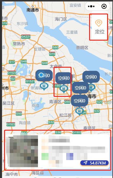
这个效果是 进入当前页面显示自己的经纬度 并 根据 pageSize,pageNum 显示当前pageSize条数据,在地图视野发生改变时 进行 this.pageNum * this.pageSize >= this.total 判断,让this.pageNum++ ,让所有的数据显示在地图上
总代码
<template>
  <view>
    <view class="map-container">
      <map style="width: 100%; height: 100vh;" :show-location='true' ref="map" id="map" :latitude="latitude"
        :longitude="longitude" :markers="marker" :scale="scale" @callouttap='callouttap' @regionchange="regionChange"
        v-if="mapShow">
        <view class="cover-view">
          <view style="margin-top: 20rpx;" @click="onControltap">
            <image class="cover-image" src="/static/images/location.png"></image>
            <view>定位</view>
          </view>
        </view>
      </map>
    </view>
    <view class="search" :style="{top:topHeight+'px'}">
      <searchBar @click="search" :city="city"></searchBar>
    </view>
    <cardList :stationList="markerIdClick" v-if="tag" style="position: fixed;top: 70%;"></cardList>
    <tabbar :current="current"></tabbar>
  </view>
</template>

<script>
  export default {
    data() {
      return {
        mapShow: false,
        topHeight: 20,
        tag: false,
        latitude: '', //纬度
        longitude: '', //经度
        scale: 12, //缩放级别
        current: 1,
        marker: [],
        pageSize: 10,
        pageNum: 1,
        total: 0, // 总数据量
        markerIdClick: [],
        mapList: [],
      }
    },
    async onLoad() {
      let userLocation = uni.getStorage({
        key: 'userLocation'
      })
      await userLocation.then(data => {
        let arr = data[1].data.split(',')
        this.longitude = arr[0]
        this.latitude = arr[1]
        console.log(arr);
      })
      this.getStationList()
      const {
        height,
        top
      } = uni.getMenuButtonBoundingClientRect();
      this.topHeight = height + top + 13
    },
    methods: {
     search(searchInp) {
        console.log('search页面子向父传值', searchInp);
      },
      regionChange() {
        this.tag = false
        if (this.pageNum * this.pageSize >= this.total) return
        this.pageNum++
        this.getStationList()
      },
      //定位
      onControltap() {
        uni.createMapContext("map", this).moveToLocation({ //moveToLocation将地图中心移动到当前定位点,需要配合map组件的show-location使用
          latitude: this.latitude,
          longitude: this.longitude,
        });
        console.log('定位');
      },
      //气泡点击事件
      callouttap(e) {
        let id = String(e.detail.markerId)
        let arr = this.mapList.find(item => {
          return item.stationId === id
        })
        this.markerIdClick = [arr]
        this.tag = true
      },
      async getStationList() {
        console.log('发送请求前 打印用户经纬度', this.latitude, this.longitude);
        const {
          data: {
            obj,
            msg,
            resCode
          }
        } = await uni.$http.post('/uniapp/pile/queryStationInfos', {
          pageSize: this.pageSize,
          pageNum: this.pageNum,
          stationLng: this.longitude,
          stationLat: this.latitude
        })
        console.log('queryStationInfos,信息列表显示总数据', obj, msg, resCode);
        if (resCode !== "00100000") return uni.$showMsg()
        this.total = obj.total
        obj.list.forEach(item => {
          this.marker.push({
            id: Number(item.stationId),
            iconPath: '/static/images/mapStation.png', //显示的图标
            title: item.stationName,
            latitude: Number(item.stationLat),
            longitude: Number(item.stationLng),
            width: 30,
            height: 30,
            callout: { //气泡窗口
              content: '空闲' + item.totalFree, //文本
              color: '#ffffff',
              fontSize: 15,
              borderRadius: 15,
              padding: '10',
              bgColor: '#406390',
              display: 'ALWAYS', //常显
            }
          })
        })
        this.mapShow = true
        this.mapList = this.mapList.concat(obj.list)
        console.log(this.marker);
        // for (let index in obj.list) {
        //   let stationMarker = {
        //     iconPath: '/static/images/mapStation.png', //显示的图标
        //     id: Number(index) || 0,
        //     title: this.mapList[index].stationName || '',
        //     latitude: Number(this.mapList[index].stationLat),
        //     longitude: Number(this.mapList[index].stationLng),
        //     width: 30,
        //     height: 30,
        //     callout: { //气泡窗口
        //       content: '空闲' + this.mapList[index].totalFree, //文本
        //       color: '#ffffff', //文字颜色
        //       fontSize: 15, //文本大小
        //       borderRadius: 15, //边框圆角
        //       padding: '10',
        //       bgColor: '#406390', //背景颜色
        //       display: 'ALWAYS', //常显
        //     }
        //   }
        //   // console.log(stationMarker, 'stationMarker');
        //   this.marker.push(stationMarker)
        // }
      }
    }
  }
</script>

<style scoped lang="scss">
  /deep/ .uni-searchbar__box-search-input {
    color: #fff !important;
  }

  .search {
    position: fixed;
    width: 80%;
  }

  .map-container {
    margin-top: -40rpx;
    position: relative;
    overflow: hidden;
    border-radius: 50rpx 50rpx 0 0;

    .cover-view {
      display: flex;
      flex-direction: column;
      align-items: center;
      justify-content: center;
      /* width: 80rpx;
			height: 160rpx; */
      padding: 42rpx 22rpx;
      color: #4F575F;
      font-weight: 400;
      background-color: #fff;
      background-size: 120rpx 120rpx;
      background-position: center center;
      position: absolute;
      top: 150rpx;
      right: 32rpx;
      border-radius: 15rpx;


    }

    .cover-image {
      display: inline-block;
      width: 50rpx;
      height: 50rpx;

    }
  }
</style>
分析
1.template 页面
(1)
<tabbar :current="current"></tabbar> current:1 此页面是自定义tab栏
(2)
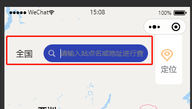
补充 动态style 也可以改为 :style="{'margin-top':topHeight+'px'}"
<view class="search" :style="{top:topHeight+'px'}">
<searchBar @click="search" :city="city"></searchBar>
</view>
动态style 就是为了 让输入框 在 胶囊下侧的位置,searchBar是我封装的组件
效果图
(3)
<cardList :stationList="markerIdClick" v-if="tag" style="position: fixed;top: 70%;"></cardList>
是我封装的组件, v-if=“tag” 默认不显示,当我点击气泡时出现的 卡片信息
(4)
地图显示代码
<view class="map-container">
      <map style="width: 100%; height: 100vh;" :show-location='true' ref="map" id="map" :latitude="latitude"
        :longitude="longitude" :markers="marker" :scale="scale" @callouttap='callouttap' @regionchange="regionChange"
        v-if="mapShow">
        <view class="cover-view">
          <view style="margin-top: 20rpx;" @click="onControltap">
            <image class="cover-image" src="/static/images/location.png"></image>
            <view>定位</view>
          </view>
        </view>
      </map>
    </view>
在 map组件 中,我只使用到了 下面那两种方法
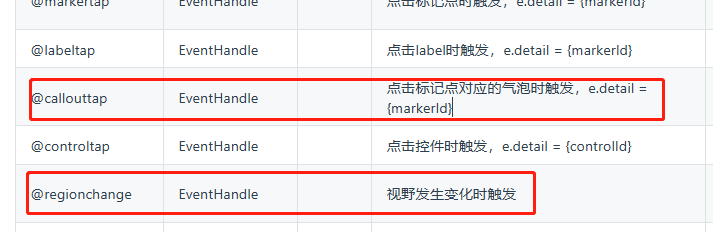
①@regionchange
当视野发生改变时,里面进行分页处理,
②@callouttap
点击标记点时 出现卡片内容
2. onload
此页面一进来
首先就是要 获取经纬度 使用这种方法获取 是因为 前面使用高德 amap-wx.130.js,这个文件帮我们把用户的经纬度存储起来了,我们只需 取就行 (注意在 amap-wx.130.js 文件中 将里面所以的 wx,替换为 uni )
①经纬度
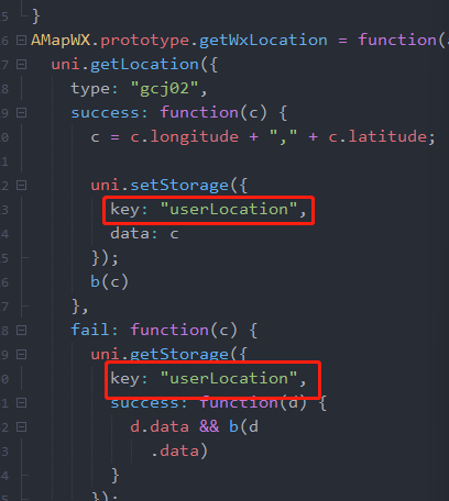
let userLocation = uni.getStorage({
key: 'userLocation'
})
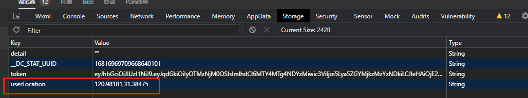
②取值
打印 userLocation 它的结果为 promise
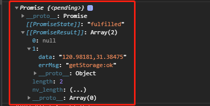
因此我们要 使用promise。then的方法取值 并赋值
③注意
最开始在onload 里 下面的
this.getStationList() 这个请求先执行,后打印经纬度,这时请求里的经纬度 就为空,
因此 加 async await,可以先获取经纬度 然后在拿经纬度发送请求
④
this.topHeight = height + top + 13
这个 13 可加可不加 根据你们原型图高度来定
  async onLoad() {
      let userLocation = uni.getStorage({
        key: 'userLocation'
      })
      await userLocation.then(data => {
        let arr = data[1].data.split(',')
        this.longitude = arr[0]
        this.latitude = arr[1]
        console.log(arr);
      })
      this.getStationList()
      const {
        height,
        top
      } = uni.getMenuButtonBoundingClientRect();
      this.topHeight = height + top + 13
      // console.log(this.topHeight, '高度');
    },
3.methods
① 先发送 getStationList 请求 获取 数组列表信息
先获取到 obj.list (列表数组)创建一个新的 marker数组
这里要注意 先获取到 obj.list (列表数组)创建一个新的 marker数组 后 要先 forEach,push (或 for ,push)返回一个 marker数组
这里的id 不能使用 index 代替 ,还有 id 、latitude 、longitude 必须是 Number类型 因为我这数据是用分页处理 若是 使用index,会有重复的id,会导致在缩放地图时 有些 marker 消失,
  obj.list.forEach(item => {
          // console.log(item, 'foreach');
          this.marker.push({
            id: Number(item.stationId),
            iconPath: '/static/images/mapStation.png', //显示的图标
            title: item.stationName,
            latitude: Number(item.stationLat),
            longitude: Number(item.stationLng),
            width: 30, //宽
            height: 30, //高
            callout: { //自定义标记点上方的气泡窗口 点击有效
              content: '空闲' + item.totalFree, //文本
              color: '#ffffff', //文字颜色
              fontSize: 15, //文本大小
              borderRadius: 15, //边框圆角
              padding: '10',
              bgColor: '#406390', //背景颜色
              display: 'ALWAYS', //常显
            }
          })
        })
后合并obj.list 数组 并赋值
this.mapList = this.mapList.concat(obj.list) (视野范围方法里需要使用 )
 async getStationList() {
        console.log('发送请求前 打印用户经纬度', this.latitude, this.longitude);
        const {
          data: {
            obj,
            msg,
            resCode
          }
        } = await uni.$http.post('/uniapp/pile/queryStationInfos', {
          pageSize: this.pageSize,
          pageNum: this.pageNum,
          stationLng: this.longitude,
          stationLat: this.latitude
        })
        console.log('queryStationInfos,查询充电站信息列表显示总数据', obj, msg, resCode);
        if (resCode !== "00100000") return uni.$showMsg()
        this.total = obj.total
        // console.log('充电站信息列表 mapList', obj.list);
        obj.list.forEach(item => {
          // console.log(item, 'foreach');
          this.marker.push({
            id: Number(item.stationId),
            iconPath: '/static/images/mapStation.png', //显示的图标
            title: item.stationName,
            latitude: Number(item.stationLat),
            longitude: Number(item.stationLng),
            width: 30, //宽
            height: 30, //高
            callout: { //自定义标记点上方的气泡窗口 点击有效
              content: '空闲' + item.totalFree, //文本
              color: '#ffffff', //文字颜色
              fontSize: 15, //文本大小
              borderRadius: 15, //边框圆角
              padding: '10',
              bgColor: '#406390', //背景颜色
              display: 'ALWAYS', //常显
            }
          })
        })
        this.mapShow = true
        this.mapList = this.mapList.concat(obj.list)
        console.log(this.marker);
        // for (let index in this.mapList) {
        //   let stationMarker = {
        //     iconPath: '/static/images/mapStation.png', //显示的图标
        //     id: Number(index) || 0,
        //     title: this.mapList[index].stationName || '',
        //     latitude: Number(this.mapList[index].stationLat),
        //     longitude: Number(this.mapList[index].stationLng),
        //     width: 30, //宽
        //     height: 30, //高
        //     callout: { //自定义标记点上方的气泡窗口 点击有效
        //       content: '空闲' + this.mapList[index].totalFree, //文本
        //       color: '#ffffff', //文字颜色
        //       fontSize: 15, //文本大小
        //       borderRadius: 15, //边框圆角
        //       padding: '10',
        //       bgColor: '#406390', //背景颜色
        //       display: 'ALWAYS', //常显
        //     }
        //   }
        //   // console.log(stationMarker, 'stationMarker');
        //   this.marker.push(stationMarker)
        // }
      }
② regionChange 视野发生变化时 触发 分页逻辑
regionChange() {
this.tag = false
if (this.pageNum * this.pageSize >= this.total) return
this.pageNum++
this.getStationList()
},
③ callouttap 点击气泡时触发 查找 当前 marker id 等于 stationId 的数组
这里要注意下类型的一个转换 e.detail.markerId --> 是 marker id 它是数字类型
而 mapList 里面的 stationId 为 字符串 类型 ,因此这要做个类型转换,若不转换的话,点击所有的 气泡,卡片上面的内容 是显示一样的
callouttap(e) {
let id = String(e.detail.markerId)
// console.log(this.mapList, id);
let arr = this.mapList.find(item => {
return item.stationId === id
})
this.markerIdClick = [arr]
// console.log('点击id', id, '数组', this.markerIdClick);
this.tag = true
},
(4)style样式
/deep/ .uni-searchbar__box-search-input {
color: #fff !important;
}
输入框默认 黑色


 1万+
1万+


 被折叠的 条评论
为什么被折叠?
被折叠的 条评论
为什么被折叠?
 到【灌水乐园】发言


