


参考地址
中途遇到的坑
- 安装 glup 时一定要切换到管理员运行状态,npm安装包安装不上都可先试试
Cesium安装
git方法安装,本文通过在VScode使用Git方法来实现的
git clone https://github.com/CesiumGS/cesium.git
- 也可在官网下载
zip包,https://cesium.com/platform/cesiumjs/ git下载的需要进行打包,需要打包后生成的Build文件夹,即为我们在项目中所使用的开发包
Cesium 源码修改 支持 Arcgis 服务 ,坐标系4490
第一步:修改 Source/Scene/ArcGisMapServerImageryProvider.js
// 256行左右,随着版本变化为位置可能有所不同
//  新增修改处1*************************************
      }else if (data.tileInfo.spatialReference.wkid === 4490) {
                    var geoTilingScheme = new GeographicTilingScheme({
                        ellipsoid : options.ellipsoid,
                        tileInfo: data.tileInfo
                    });
                    that._tilingScheme = geoTilingScheme;
      }
//  新增修改处1*************************************

// 355 行附近
//新增修改处2*************************
else if (data.fullExtent.spatialReference.wkid === 4326|| data.fullExtent.spatialReference.wkid === 4490) {
            that._rectangle = Rectangle.fromDegrees(
              data.fullExtent.xmin,
              data.fullExtent.ymin,
              data.fullExtent.xmax,
              data.fullExtent.ymax
            );
          }
//新增修改处2*************************
完整代码
import Cartesian2 from "../Core/Cartesian2.js";
import Cartesian3 from "../Core/Cartesian3.js";
import Cartographic from "../Core/Cartographic.js";
import Credit from "../Core/Credit.js";
import defaultValue from "../Core/defaultValue.js";
import defined from "../Core/defined.js";
import DeveloperError from "../Core/DeveloperError.js";
import Event from "../Core/Event.js";
import GeographicProjection from "../Core/GeographicProjection.js";
import GeographicTilingScheme from "../Core/GeographicTilingScheme.js";
import CesiumMath from "../Core/Math.js";
import Rectangle from "../Core/Rectangle.js";
import Resource from "../Core/Resource.js";
import RuntimeError from "../Core/RuntimeError.js";
import TileProviderError from "../Core/TileProviderError.js";
import WebMercatorProjection from "../Core/WebMercatorProjection.js";
import WebMercatorTilingScheme from "../Core/WebMercatorTilingScheme.js";
import when from "../ThirdParty/when.js";
import DiscardMissingTileImagePolicy from "./DiscardMissingTileImagePolicy.js";
import ImageryLayerFeatureInfo from "./ImageryLayerFeatureInfo.js";
import ImageryProvider from "./ImageryProvider.js";

/**
 * @typedef {Object} ArcGisMapServerImageryProvider.ConstructorOptions
 *
 * Initialization options for the ArcGisMapServerImageryProvider constructor
 *
 * @property {Resource|String} url The URL of the ArcGIS MapServer service.
 * @property {String} [token] The ArcGIS token used to authenticate with the ArcGIS MapServer service.
 * @property {TileDiscardPolicy} [tileDiscardPolicy] The policy that determines if a tile
 *        is invalid and should be discarded.  If this value is not specified, a default
 *        {@link DiscardMissingTileImagePolicy} is used for tiled map servers, and a
 *        {@link NeverTileDiscardPolicy} is used for non-tiled map servers.  In the former case,
 *        we request tile 0,0 at the maximum tile level and check pixels (0,0), (200,20), (20,200),
 *        (80,110), and (160, 130).  If all of these pixels are transparent, the discard check is
 *        disabled and no tiles are discarded.  If any of them have a non-transparent color, any
 *        tile that has the same values in these pixel locations is discarded.  The end result of
 *        these defaults should be correct tile discarding for a standard ArcGIS Server.  To ensure
 *        that no tiles are discarded, construct and pass a {@link NeverTileDiscardPolicy} for this
 *        parameter.
 * @property {Boolean} [usePreCachedTilesIfAvailable=true] If true, the server's pre-cached
 *        tiles are used if they are available.  If false, any pre-cached tiles are ignored and the
 *        'export' service is used.
 * @property {String} [layers] A comma-separated list of the layers to show, or undefined if all layers should be shown.
 * @property {Boolean} [enablePickFeatures=true] If true, {@link ArcGisMapServerImageryProvider#pickFeatures} will invoke
 *        the Identify service on the MapServer and return the features included in the response.  If false,
 *        {@link ArcGisMapServerImageryProvider#pickFeatures} will immediately return undefined (indicating no pickable features)
 *        without communicating with the server.  Set this property to false if you don't want this provider's features to
 *        be pickable. Can be overridden by setting the {@link ArcGisMapServerImageryProvider#enablePickFeatures} property on the object.
 * @property {Rectangle} [rectangle=Rectangle.MAX_VALUE] The rectangle of the layer.  This parameter is ignored when accessing
 *                    a tiled layer.
 * @property {TilingScheme} [tilingScheme=new GeographicTilingScheme()] The tiling scheme to use to divide the world into tiles.
 *                       This parameter is ignored when accessing a tiled server.
 * @property {Ellipsoid} [ellipsoid] The ellipsoid.  If the tilingScheme is specified and used,
 *                    this parameter is ignored and the tiling scheme's ellipsoid is used instead. If neither
 *                    parameter is specified, the WGS84 ellipsoid is used.
 * @property {Credit|String} [credit] A credit for the data source, which is displayed on the canvas.  This parameter is ignored when accessing a tiled server.
 * @property {Number} [tileWidth=256] The width of each tile in pixels.  This parameter is ignored when accessing a tiled server.
 * @property {Number} [tileHeight=256] The height of each tile in pixels.  This parameter is ignored when accessing a tiled server.
 * @property {Number} [maximumLevel] The maximum tile level to request, or undefined if there is no maximum.  This parameter is ignored when accessing
 *                                        a tiled server.
 */

/**
 * Provides tiled imagery hosted by an ArcGIS MapServer.  By default, the server's pre-cached tiles are
 * used, if available.
 *
 * @alias ArcGisMapServerImageryProvider
 * @constructor
 *
 * @param {ArcGisMapServerImageryProvider.ConstructorOptions} options Object describing initialization options
 *
 * @see BingMapsImageryProvider
 * @see GoogleEarthEnterpriseMapsProvider
 * @see OpenStreetMapImageryProvider
 * @see SingleTileImageryProvider
 * @see TileMapServiceImageryProvider
 * @see WebMapServiceImageryProvider
 * @see WebMapTileServiceImageryProvider
 * @see UrlTemplateImageryProvider
 *
 *
 * @example
 * var esri = new Cesium.ArcGisMapServerImageryProvider({
 *     url : 'https://services.arcgisonline.com/ArcGIS/rest/services/World_Imagery/MapServer'
 * });
 *
 * @see {@link https://developers.arcgis.com/rest/|ArcGIS Server REST API}
 * @see {@link http://www.w3.org/TR/cors/|Cross-Origin Resource Sharing}
 */
function ArcGisMapServerImageryProvider(options) {
  options = defaultValue(options, defaultValue.EMPTY_OBJECT);

  //>>includeStart('debug', pragmas.debug);
  if (!defined(options.url)) {
    throw new DeveloperError("options.url is required.");
  }
  //>>includeEnd('debug');

  /**
   * The default alpha blending value of this provider, with 0.0 representing fully transparent and
   * 1.0 representing fully opaque.
   *
   * @type {Number|undefined}
   * @default undefined
   */
  this.defaultAlpha = undefined;

  /**
   * The default alpha blending value on the night side of the globe of this provider, with 0.0 representing fully transparent and
   * 1.0 representing fully opaque.
   *
   * @type {Number|undefined}
   * @default undefined
   */
  this.defaultNightAlpha = undefined;

  /**
   * The default alpha blending value on the day side of the globe of this provider, with 0.0 representing fully transparent and
   * 1.0 representing fully opaque.
   *
   * @type {Number|undefined}
   * @default undefined
   */
  this.defaultDayAlpha = undefined;

  /**
   * The default brightness of this provider.  1.0 uses the unmodified imagery color.  Less than 1.0
   * makes the imagery darker while greater than 1.0 makes it brighter.
   *
   * @type {Number|undefined}
   * @default undefined
   */
  this.defaultBrightness = undefined;

  /**
   * The default contrast of this provider.  1.0 uses the unmodified imagery color.  Less than 1.0 reduces
   * the contrast while greater than 1.0 increases it.
   *
   * @type {Number|undefined}
   * @default undefined
   */
  this.defaultContrast = undefined;

  /**
   * The default hue of this provider in radians. 0.0 uses the unmodified imagery color.
   *
   * @type {Number|undefined}
   * @default undefined
   */
  this.defaultHue = undefined;

  /**
   * The default saturation of this provider. 1.0 uses the unmodified imagery color. Less than 1.0 reduces the
   * saturation while greater than 1.0 increases it.
   *
   * @type {Number|undefined}
   * @default undefined
   */
  this.defaultSaturation = undefined;

  /**
   * The default gamma correction to apply to this provider.  1.0 uses the unmodified imagery color.
   *
   * @type {Number|undefined}
   * @default undefined
   */
  this.defaultGamma = undefined;

  /**
   * The default texture minification filter to apply to this provider.
   *
   * @type {TextureMinificationFilter}
   * @default undefined
   */
  this.defaultMinificationFilter = undefined;

  /**
   * The default texture magnification filter to apply to this provider.
   *
   * @type {TextureMagnificationFilter}
   * @default undefined
   */
  this.defaultMagnificationFilter = undefined;

  var resource = Resource.createIfNeeded(options.url);
  resource.appendForwardSlash();

  if (defined(options.token)) {
    resource.setQueryParameters({
      token: options.token,
    });
  }

  this._resource = resource;
  this._tileDiscardPolicy = options.tileDiscardPolicy;

  this._tileWidth = defaultValue(options.tileWidth, 256);
  this._tileHeight = defaultValue(options.tileHeight, 256);
  this._maximumLevel = options.maximumLevel;
  this._tilingScheme = defaultValue(
    options.tilingScheme,
    new GeographicTilingScheme({ ellipsoid: options.ellipsoid })
  );
  this._useTiles = defaultValue(options.usePreCachedTilesIfAvailable, true);
  this._rectangle = defaultValue(
    options.rectangle,
    this._tilingScheme.rectangle
  );
  this._layers = options.layers;

  var credit = options.credit;
  if (typeof credit === "string") {
    credit = new Credit(credit);
  }
  this._credit = credit;

  /**
   * Gets or sets a value indicating whether feature picking is enabled.  If true, {@link ArcGisMapServerImageryProvider#pickFeatures} will
   * invoke the "identify" operation on the ArcGIS server and return the features included in the response.  If false,
   * {@link ArcGisMapServerImageryProvider#pickFeatures} will immediately return undefined (indicating no pickable features)
   * without communicating with the server.
   * @type {Boolean}
   * @default true
   */
  this.enablePickFeatures = defaultValue(options.enablePickFeatures, true);

  this._errorEvent = new Event();

  this._ready = false;
  this._readyPromise = when.defer();

  // Grab the details of this MapServer.
  var that = this;
  var metadataError;

  function metadataSuccess(data) {
    var tileInfo = data.tileInfo;
    if (!defined(tileInfo)) {
      that._useTiles = false;
    } else {
      that._tileWidth = tileInfo.rows;
      that._tileHeight = tileInfo.cols;

      if (
        tileInfo.spatialReference.wkid === 102100 ||
        tileInfo.spatialReference.wkid === 102113
      ) {
        that._tilingScheme = new WebMercatorTilingScheme({
          ellipsoid: options.ellipsoid,
        });
      } else if (data.tileInfo.spatialReference.wkid === 4326) {
        that._tilingScheme = new GeographicTilingScheme({
          ellipsoid: options.ellipsoid,
        });
      } else if (data.tileInfo.spatialReference.wkid === 4490) {
        var geoTilingScheme = new GeographicTilingScheme({
            ellipsoid : options.ellipsoid,
            tileInfo: data.tileInfo
        });
        that._tilingScheme = geoTilingScheme;
} else {
        var message =
          "Tile spatial reference WKID " +
          data.tileInfo.spatialReference.wkid +
          " is not supported.";
        metadataError = TileProviderError.handleError(
          metadataError,
          that,
          that._errorEvent,
          message,
          undefined,
          undefined,
          undefined,
          requestMetadata
        );
        return;
      }
      that._maximumLevel = data.tileInfo.lods.length - 1;

      if (defined(data.fullExtent)) {
        if (
          defined(data.fullExtent.spatialReference) &&
          defined(data.fullExtent.spatialReference.wkid)
        ) {
          if (
            data.fullExtent.spatialReference.wkid === 102100 ||
            data.fullExtent.spatialReference.wkid === 102113
          ) {
            var projection = new WebMercatorProjection();
            var extent = data.fullExtent;
            var sw = projection.unproject(
              new Cartesian3(
                Math.max(
                  extent.xmin,
                  -that._tilingScheme.ellipsoid.maximumRadius * Math.PI
                ),
                Math.max(
                  extent.ymin,
                  -that._tilingScheme.ellipsoid.maximumRadius * Math.PI
                ),
                0.0
              )
            );
            var ne = projection.unproject(
              new Cartesian3(
                Math.min(
                  extent.xmax,
                  that._tilingScheme.ellipsoid.maximumRadius * Math.PI
                ),
                Math.min(
                  extent.ymax,
                  that._tilingScheme.ellipsoid.maximumRadius * Math.PI
                ),
                0.0
              )
            );
            that._rectangle = new Rectangle(
              sw.longitude,
              sw.latitude,
              ne.longitude,
              ne.latitude
            );
          } else if (data.fullExtent.spatialReference.wkid === 4326) {
            that._rectangle = Rectangle.fromDegrees(
              data.fullExtent.xmin,
              data.fullExtent.ymin,
              data.fullExtent.xmax,
              data.fullExtent.ymax
            );
          } else if (data.fullExtent.spatialReference.wkid === 4326|| data.fullExtent.spatialReference.wkid === 4490) {
            that._rectangle = Rectangle.fromDegrees(
              data.fullExtent.xmin,
              data.fullExtent.ymin,
              data.fullExtent.xmax,
              data.fullExtent.ymax
            );
          } else {
            var extentMessage =
              "fullExtent.spatialReference WKID " +
              data.fullExtent.spatialReference.wkid +
              " is not supported.";
            metadataError = TileProviderError.handleError(
              metadataError,
              that,
              that._errorEvent,
              extentMessage,
              undefined,
              undefined,
              undefined,
              requestMetadata
            );
            return;
          }
        }
      } else {
        that._rectangle = that._tilingScheme.rectangle;
      }

      // Install the default tile discard policy if none has been supplied.
      if (!defined(that._tileDiscardPolicy)) {
        that._tileDiscardPolicy = new DiscardMissingTileImagePolicy({
          missingImageUrl: buildImageResource(that, 0, 0, that._maximumLevel)
            .url,
          pixelsToCheck: [
            new Cartesian2(0, 0),
            new Cartesian2(200, 20),
            new Cartesian2(20, 200),
            new Cartesian2(80, 110),
            new Cartesian2(160, 130),
          ],
          disableCheckIfAllPixelsAreTransparent: true,
        });
      }

      that._useTiles = true;
    }

    if (defined(data.copyrightText) && data.copyrightText.length > 0) {
      that._credit = new Credit(data.copyrightText);
    }

    that._ready = true;
    that._readyPromise.resolve(true);
    TileProviderError.handleSuccess(metadataError);
  }

  function metadataFailure(e) {
    var message =
      "An error occurred while accessing " + that._resource.url + ".";
    metadataError = TileProviderError.handleError(
      metadataError,
      that,
      that._errorEvent,
      message,
      undefined,
      undefined,
      undefined,
      requestMetadata
    );
    that._readyPromise.reject(new RuntimeError(message));
  }

  function requestMetadata() {
    var resource = that._resource.getDerivedResource({
      queryParameters: {
        f: "json",
      },
    });
    var metadata = resource.fetchJsonp();
    when(metadata, metadataSuccess, metadataFailure);
  }

  if (this._useTiles) {
    requestMetadata();
  } else {
    this._ready = true;
    this._readyPromise.resolve(true);
  }
}

function buildImageResource(imageryProvider, x, y, level, request) {
  var resource;
  if (imageryProvider._useTiles) {
    resource = imageryProvider._resource.getDerivedResource({
      url: "tile/" + level + "/" + y + "/" + x,
      request: request,
    });
  } else {
    var nativeRectangle = imageryProvider._tilingScheme.tileXYToNativeRectangle(
      x,
      y,
      level
    );
    var bbox =
      nativeRectangle.west +
      "," +
      nativeRectangle.south +
      "," +
      nativeRectangle.east +
      "," +
      nativeRectangle.north;

    var query = {
      bbox: bbox,
      size: imageryProvider._tileWidth + "," + imageryProvider._tileHeight,
      format: "png32",
      transparent: true,
      f: "image",
    };

    if (
      imageryProvider._tilingScheme.projection instanceof GeographicProjection
    ) {
      query.bboxSR = 4326;
      query.imageSR = 4326;
    } else {
      query.bboxSR = 3857;
      query.imageSR = 3857;
    }
    if (imageryProvider.layers) {
      query.layers = "show:" + imageryProvider.layers;
    }

    resource = imageryProvider._resource.getDerivedResource({
      url: "export",
      request: request,
      queryParameters: query,
    });
  }

  return resource;
}

Object.defineProperties(ArcGisMapServerImageryProvider.prototype, {
  /**
   * Gets the URL of the ArcGIS MapServer.
   * @memberof ArcGisMapServerImageryProvider.prototype
   * @type {String}
   * @readonly
   */
  url: {
    get: function () {
      return this._resource._url;
    },
  },

  /**
   * Gets the ArcGIS token used to authenticate with the ArcGis MapServer service.
   * @memberof ArcGisMapServerImageryProvider.prototype
   * @type {String}
   * @readonly
   */
  token: {
    get: function () {
      return this._resource.queryParameters.token;
    },
  },

  /**
   * Gets the proxy used by this provider.
   * @memberof ArcGisMapServerImageryProvider.prototype
   * @type {Proxy}
   * @readonly
   */
  proxy: {
    get: function () {
      return this._resource.proxy;
    },
  },

  /**
   * Gets the width of each tile, in pixels. This function should
   * not be called before {@link ArcGisMapServerImageryProvider#ready} returns true.
   * @memberof ArcGisMapServerImageryProvider.prototype
   * @type {Number}
   * @readonly
   */
  tileWidth: {
    get: function () {
      //>>includeStart('debug', pragmas.debug);
      if (!this._ready) {
        throw new DeveloperError(
          "tileWidth must not be called before the imagery provider is ready."
        );
      }
      //>>includeEnd('debug');

      return this._tileWidth;
    },
  },

  /**
   * Gets the height of each tile, in pixels.  This function should
   * not be called before {@link ArcGisMapServerImageryProvider#ready} returns true.
   * @memberof ArcGisMapServerImageryProvider.prototype
   * @type {Number}
   * @readonly
   */
  tileHeight: {
    get: function () {
      //>>includeStart('debug', pragmas.debug);
      if (!this._ready) {
        throw new DeveloperError(
          "tileHeight must not be called before the imagery provider is ready."
        );
      }
      //>>includeEnd('debug');

      return this._tileHeight;
    },
  },

  /**
   * Gets the maximum level-of-detail that can be requested.  This function should
   * not be called before {@link ArcGisMapServerImageryProvider#ready} returns true.
   * @memberof ArcGisMapServerImageryProvider.prototype
   * @type {Number|undefined}
   * @readonly
   */
  maximumLevel: {
    get: function () {
      //>>includeStart('debug', pragmas.debug);
      if (!this._ready) {
        throw new DeveloperError(
          "maximumLevel must not be called before the imagery provider is ready."
        );
      }
      //>>includeEnd('debug');

      return this._maximumLevel;
    },
  },

  /**
   * Gets the minimum level-of-detail that can be requested.  This function should
   * not be called before {@link ArcGisMapServerImageryProvider#ready} returns true.
   * @memberof ArcGisMapServerImageryProvider.prototype
   * @type {Number}
   * @readonly
   */
  minimumLevel: {
    get: function () {
      //>>includeStart('debug', pragmas.debug);
      if (!this._ready) {
        throw new DeveloperError(
          "minimumLevel must not be called before the imagery provider is ready."
        );
      }
      //>>includeEnd('debug');

      return 0;
    },
  },

  /**
   * Gets the tiling scheme used by this provider.  This function should
   * not be called before {@link ArcGisMapServerImageryProvider#ready} returns true.
   * @memberof ArcGisMapServerImageryProvider.prototype
   * @type {TilingScheme}
   * @readonly
   */
  tilingScheme: {
    get: function () {
      //>>includeStart('debug', pragmas.debug);
      if (!this._ready) {
        throw new DeveloperError(
          "tilingScheme must not be called before the imagery provider is ready."
        );
      }
      //>>includeEnd('debug');

      return this._tilingScheme;
    },
  },

  /**
   * Gets the rectangle, in radians, of the imagery provided by this instance.  This function should
   * not be called before {@link ArcGisMapServerImageryProvider#ready} returns true.
   * @memberof ArcGisMapServerImageryProvider.prototype
   * @type {Rectangle}
   * @readonly
   */
  rectangle: {
    get: function () {
      //>>includeStart('debug', pragmas.debug);
      if (!this._ready) {
        throw new DeveloperError(
          "rectangle must not be called before the imagery provider is ready."
        );
      }
      //>>includeEnd('debug');

      return this._rectangle;
    },
  },

  /**
   * Gets the tile discard policy.  If not undefined, the discard policy is responsible
   * for filtering out "missing" tiles via its shouldDiscardImage function.  If this function
   * returns undefined, no tiles are filtered.  This function should
   * not be called before {@link ArcGisMapServerImageryProvider#ready} returns true.
   * @memberof ArcGisMapServerImageryProvider.prototype
   * @type {TileDiscardPolicy}
   * @readonly
   */
  tileDiscardPolicy: {
    get: function () {
      //>>includeStart('debug', pragmas.debug);
      if (!this._ready) {
        throw new DeveloperError(
          "tileDiscardPolicy must not be called before the imagery provider is ready."
        );
      }
      //>>includeEnd('debug');

      return this._tileDiscardPolicy;
    },
  },

  /**
   * Gets an event that is raised when the imagery provider encounters an asynchronous error.  By subscribing
   * to the event, you will be notified of the error and can potentially recover from it.  Event listeners
   * are passed an instance of {@link TileProviderError}.
   * @memberof ArcGisMapServerImageryProvider.prototype
   * @type {Event}
   * @readonly
   */
  errorEvent: {
    get: function () {
      return this._errorEvent;
    },
  },

  /**
   * Gets a value indicating whether or not the provider is ready for use.
   * @memberof ArcGisMapServerImageryProvider.prototype
   * @type {Boolean}
   * @readonly
   */
  ready: {
    get: function () {
      return this._ready;
    },
  },

  /**
   * Gets a promise that resolves to true when the provider is ready for use.
   * @memberof ArcGisMapServerImageryProvider.prototype
   * @type {Promise.<Boolean>}
   * @readonly
   */
  readyPromise: {
    get: function () {
      return this._readyPromise.promise;
    },
  },

  /**
   * Gets the credit to display when this imagery provider is active.  Typically this is used to credit
   * the source of the imagery.  This function should not be called before {@link ArcGisMapServerImageryProvider#ready} returns true.
   * @memberof ArcGisMapServerImageryProvider.prototype
   * @type {Credit}
   * @readonly
   */
  credit: {
    get: function () {
      return this._credit;
    },
  },

  /**
   * Gets a value indicating whether this imagery provider is using pre-cached tiles from the
   * ArcGIS MapServer.  If the imagery provider is not yet ready ({@link ArcGisMapServerImageryProvider#ready}), this function
   * will return the value of `options.usePreCachedTilesIfAvailable`, even if the MapServer does
   * not have pre-cached tiles.
   * @memberof ArcGisMapServerImageryProvider.prototype
   *
   * @type {Boolean}
   * @readonly
   * @default true
   */
  usingPrecachedTiles: {
    get: function () {
      return this._useTiles;
    },
  },

  /**
   * Gets a value indicating whether or not the images provided by this imagery provider
   * include an alpha channel.  If this property is false, an alpha channel, if present, will
   * be ignored.  If this property is true, any images without an alpha channel will be treated
   * as if their alpha is 1.0 everywhere.  When this property is false, memory usage
   * and texture upload time are reduced.
   * @memberof ArcGisMapServerImageryProvider.prototype
   *
   * @type {Boolean}
   * @readonly
   * @default true
   */
  hasAlphaChannel: {
    get: function () {
      return true;
    },
  },

  /**
   * Gets the comma-separated list of layer IDs to show.
   * @memberof ArcGisMapServerImageryProvider.prototype
   *
   * @type {String}
   */
  layers: {
    get: function () {
      return this._layers;
    },
  },
});

/**
 * Gets the credits to be displayed when a given tile is displayed.
 *
 * @param {Number} x The tile X coordinate.
 * @param {Number} y The tile Y coordinate.
 * @param {Number} level The tile level;
 * @returns {Credit[]} The credits to be displayed when the tile is displayed.
 *
 * @exception {DeveloperError} <code>getTileCredits</code> must not be called before the imagery provider is ready.
 */
ArcGisMapServerImageryProvider.prototype.getTileCredits = function (
  x,
  y,
  level
) {
  return undefined;
};

/**
 * Requests the image for a given tile.  This function should
 * not be called before {@link ArcGisMapServerImageryProvider#ready} returns true.
 *
 * @param {Number} x The tile X coordinate.
 * @param {Number} y The tile Y coordinate.
 * @param {Number} level The tile level.
 * @param {Request} [request] The request object. Intended for internal use only.
 * @returns {Promise.<HTMLImageElement|HTMLCanvasElement>|undefined} A promise for the image that will resolve when the image is available, or
 *          undefined if there are too many active requests to the server, and the request
 *          should be retried later.  The resolved image may be either an
 *          Image or a Canvas DOM object.
 *
 * @exception {DeveloperError} <code>requestImage</code> must not be called before the imagery provider is ready.
 */
ArcGisMapServerImageryProvider.prototype.requestImage = function (
  x,
  y,
  level,
  request
) {
  //>>includeStart('debug', pragmas.debug);
  if (!this._ready) {
    throw new DeveloperError(
      "requestImage must not be called before the imagery provider is ready."
    );
  }
  //>>includeEnd('debug');

  return ImageryProvider.loadImage(
    this,
    buildImageResource(this, x, y, level, request)
  );
};

/**
    /**
     * Asynchronously determines what features, if any, are located at a given longitude and latitude within
     * a tile.  This function should not be called before {@link ImageryProvider#ready} returns true.
     *
     * @param {Number} x The tile X coordinate.
     * @param {Number} y The tile Y coordinate.
     * @param {Number} level The tile level.
     * @param {Number} longitude The longitude at which to pick features.
     * @param {Number} latitude  The latitude at which to pick features.
     * @return {Promise.<ImageryLayerFeatureInfo[]>|undefined} A promise for the picked features that will resolve when the asynchronous
     *                   picking completes.  The resolved value is an array of {@link ImageryLayerFeatureInfo}
     *                   instances.  The array may be empty if no features are found at the given location.
     *
     * @exception {DeveloperError} <code>pickFeatures</code> must not be called before the imagery provider is ready.
     */
ArcGisMapServerImageryProvider.prototype.pickFeatures = function (
  x,
  y,
  level,
  longitude,
  latitude
) {
  //>>includeStart('debug', pragmas.debug);
  if (!this._ready) {
    throw new DeveloperError(
      "pickFeatures must not be called before the imagery provider is ready."
    );
  }
  //>>includeEnd('debug');

  if (!this.enablePickFeatures) {
    return undefined;
  }

  var rectangle = this._tilingScheme.tileXYToNativeRectangle(x, y, level);

  var horizontal;
  var vertical;
  var sr;
  if (this._tilingScheme.projection instanceof GeographicProjection) {
    horizontal = CesiumMath.toDegrees(longitude);
    vertical = CesiumMath.toDegrees(latitude);
    sr = "4326";
  } else {
    var projected = this._tilingScheme.projection.project(
      new Cartographic(longitude, latitude, 0.0)
    );
    horizontal = projected.x;
    vertical = projected.y;
    sr = "3857";
  }

  var layers = "visible";
  if (defined(this._layers)) {
    layers += ":" + this._layers;
  }

  var query = {
    f: "json",
    tolerance: 2,
    geometryType: "esriGeometryPoint",
    geometry: horizontal + "," + vertical,
    mapExtent:
      rectangle.west +
      "," +
      rectangle.south +
      "," +
      rectangle.east +
      "," +
      rectangle.north,
    imageDisplay: this._tileWidth + "," + this._tileHeight + ",96",
    sr: sr,
    layers: layers,
  };

  var resource = this._resource.getDerivedResource({
    url: "identify",
    queryParameters: query,
  });

  return resource.fetchJson().then(function (json) {
    var result = [];

    var features = json.results;
    if (!defined(features)) {
      return result;
    }

    for (var i = 0; i < features.length; ++i) {
      var feature = features[i];

      var featureInfo = new ImageryLayerFeatureInfo();
      featureInfo.data = feature;
      featureInfo.name = feature.value;
      featureInfo.properties = feature.attributes;
      featureInfo.configureDescriptionFromProperties(feature.attributes);

      // If this is a point feature, use the coordinates of the point.
      if (feature.geometryType === "esriGeometryPoint" && feature.geometry) {
        var wkid =
          feature.geometry.spatialReference &&
          feature.geometry.spatialReference.wkid
            ? feature.geometry.spatialReference.wkid
            : 4326;
        if (wkid === 4326 || wkid === 4283) {
          featureInfo.position = Cartographic.fromDegrees(
            feature.geometry.x,
            feature.geometry.y,
            feature.geometry.z
          );
        } else if (wkid === 102100 || wkid === 900913 || wkid === 3857) {
          var projection = new WebMercatorProjection();
          featureInfo.position = projection.unproject(
            new Cartesian3(
              feature.geometry.x,
              feature.geometry.y,
              feature.geometry.z
            )
          );
        }
      }

      result.push(featureInfo);
    }

    return result;
  });
};
export default ArcGisMapServerImageryProvider;
第二步:修改Source/Core/GeographicTilingScheme.js
import Cartesian2 from "./Cartesian2.js";
import Check from "./Check.js";
import defaultValue from "./defaultValue.js";
import defined from "./defined.js";
import Ellipsoid from "./Ellipsoid.js";
import GeographicProjection from "./GeographicProjection.js";
import CesiumMath from "./Math.js";
import Rectangle from "./Rectangle.js";

/**
 * A tiling scheme for geometry referenced to a simple {@link GeographicProjection} where
 * longitude and latitude are directly mapped to X and Y.  This projection is commonly
 * known as geographic, equirectangular, equidistant cylindrical, or plate carrée.
 *
 * @alias GeographicTilingScheme
 * @constructor
 *
 * @param {Object} [options] Object with the following properties:
 * @param {Ellipsoid} [options.ellipsoid=Ellipsoid.WGS84] The ellipsoid whose surface is being tiled. Defaults to
 * the WGS84 ellipsoid.
 * @param {Rectangle} [options.rectangle=Rectangle.MAX_VALUE] The rectangle, in radians, covered by the tiling scheme.
 * @param {Number} [options.numberOfLevelZeroTilesX=2] The number of tiles in the X direction at level zero of
 * the tile tree.
 * @param {Number} [options.numberOfLevelZeroTilesY=1] The number of tiles in the Y direction at level zero of
 * the tile tree.
 */
function GeographicTilingScheme(options) {
  options = defaultValue(options, defaultValue.EMPTY_OBJECT);

  /*
  this._ellipsoid = defaultValue(options.ellipsoid, Ellipsoid.WGS84);
  this._rectangle = defaultValue(options.rectangle, Rectangle.MAX_VALUE);
  this._projection = new GeographicProjection(this._ellipsoid);
  this._numberOfLevelZeroTilesX = defaultValue(
    options.numberOfLevelZeroTilesX,
    2
  );
  this._numberOfLevelZeroTilesY = defaultValue(
    options.numberOfLevelZeroTilesY,
    1
  );
  */
     if( defined(options.tileInfo)
            && defined(options.tileInfo.spatialReference)
            && defined(options.tileInfo.spatialReference.wkid)
            && options.tileInfo.spatialReference.wkid == 4490 )
        {
            this._tileInfo = options.tileInfo;
            this._ellipsoid = defaultValue(options.ellipsoid, Ellipsoid.CGCS2000);
            this._rectangle = defaultValue(options.rectangle, Rectangle.fromDegrees(-180, -90, 180, 90));
            this._numberOfLevelZeroTilesX = defaultValue(options.numberOfLevelZeroTilesX, 4);
            this._numberOfLevelZeroTilesY = defaultValue(options.numberOfLevelZeroTilesY, 2);
        }
        else
        {
            this._ellipsoid = defaultValue(options.ellipsoid, Ellipsoid.WGS84);
            this._rectangle = defaultValue(options.rectangle, Rectangle.MAX_VALUE);
            this._numberOfLevelZeroTilesX = defaultValue(options.numberOfLevelZeroTilesX, 2);
            this._numberOfLevelZeroTilesY = defaultValue(options.numberOfLevelZeroTilesY, 1);
        }

        this._projection = new GeographicProjection(this._ellipsoid);
}

Object.defineProperties(GeographicTilingScheme.prototype, {
  /**
   * Gets the ellipsoid that is tiled by this tiling scheme.
   * @memberof GeographicTilingScheme.prototype
   * @type {Ellipsoid}
   */
  ellipsoid: {
    get: function () {
      return this._ellipsoid;
    },
  },

  /**
   * Gets the rectangle, in radians, covered by this tiling scheme.
   * @memberof GeographicTilingScheme.prototype
   * @type {Rectangle}
   */
  rectangle: {
    get: function () {
      return this._rectangle;
    },
  },

  /**
   * Gets the map projection used by this tiling scheme.
   * @memberof GeographicTilingScheme.prototype
   * @type {MapProjection}
   */
  projection: {
    get: function () {
      return this._projection;
    },
  },
});

/**
 * Gets the total number of tiles in the X direction at a specified level-of-detail.
 *
 * @param {Number} level The level-of-detail.
 * @returns {Number} The number of tiles in the X direction at the given level.
 */
GeographicTilingScheme.prototype.getNumberOfXTilesAtLevel = function (level) {
     //return this._numberOfLevelZeroTilesX << level; 源码
	    if(!defined(this._tileInfo))
        {
            return this._numberOfLevelZeroTilesX << level;
        }
        else
        {
            var currentMatrix = this._tileInfo.lods.filter(function(item){
                return item.level === level;
            });
            var currentResolution = currentMatrix[0].resolution;
            return Math.round(CesiumMath.toDegrees(CesiumMath.TWO_PI) / (this._tileInfo.rows * currentResolution));
        }
};

/**
 * Gets the total number of tiles in the Y direction at a specified level-of-detail.
 *
 * @param {Number} level The level-of-detail.
 * @returns {Number} The number of tiles in the Y direction at the given level.
 */
GeographicTilingScheme.prototype.getNumberOfYTilesAtLevel = function (level) {
     //return this._numberOfLevelZeroTilesY << level;  //源码
	 if(!defined(this._tileInfo))
        {
            return this._numberOfLevelZeroTilesY << level;
        }
        else
        {
            var currentMatrix = this._tileInfo.lods.filter(function(item){
                return item.level === level;
            });
            var currentResolution = currentMatrix[0].resolution;
            return Math.round(CesiumMath.toDegrees(CesiumMath.TWO_PI / 2) / (this._tileInfo.cols * currentResolution));
        }
};

/**
 * Transforms a rectangle specified in geodetic radians to the native coordinate system
 * of this tiling scheme.
 *
 * @param {Rectangle} rectangle The rectangle to transform.
 * @param {Rectangle} [result] The instance to which to copy the result, or undefined if a new instance
 *        should be created.
 * @returns {Rectangle} The specified 'result', or a new object containing the native rectangle if 'result'
 *          is undefined.
 */
GeographicTilingScheme.prototype.rectangleToNativeRectangle = function (
  rectangle,
  result
) {
  //>>includeStart('debug', pragmas.debug);
  Check.defined("rectangle", rectangle);
  //>>includeEnd('debug');

  var west = CesiumMath.toDegrees(rectangle.west);
  var south = CesiumMath.toDegrees(rectangle.south);
  var east = CesiumMath.toDegrees(rectangle.east);
  var north = CesiumMath.toDegrees(rectangle.north);

  if (!defined(result)) {
    return new Rectangle(west, south, east, north);
  }

  result.west = west;
  result.south = south;
  result.east = east;
  result.north = north;
  return result;
};

/**
 * Converts tile x, y coordinates and level to a rectangle expressed in the native coordinates
 * of the tiling scheme.
 *
 * @param {Number} x The integer x coordinate of the tile.
 * @param {Number} y The integer y coordinate of the tile.
 * @param {Number} level The tile level-of-detail.  Zero is the least detailed.
 * @param {Object} [result] The instance to which to copy the result, or undefined if a new instance
 *        should be created.
 * @returns {Rectangle} The specified 'result', or a new object containing the rectangle
 *          if 'result' is undefined.
 */
GeographicTilingScheme.prototype.tileXYToNativeRectangle = function (
  x,
  y,
  level,
  result
) {
  var rectangleRadians = this.tileXYToRectangle(x, y, level, result);
  rectangleRadians.west = CesiumMath.toDegrees(rectangleRadians.west);
  rectangleRadians.south = CesiumMath.toDegrees(rectangleRadians.south);
  rectangleRadians.east = CesiumMath.toDegrees(rectangleRadians.east);
  rectangleRadians.north = CesiumMath.toDegrees(rectangleRadians.north);
  return rectangleRadians;
};

/**
 * Converts tile x, y coordinates and level to a cartographic rectangle in radians.
 *
 * @param {Number} x The integer x coordinate of the tile.
 * @param {Number} y The integer y coordinate of the tile.
 * @param {Number} level The tile level-of-detail.  Zero is the least detailed.
 * @param {Object} [result] The instance to which to copy the result, or undefined if a new instance
 *        should be created.
 * @returns {Rectangle} The specified 'result', or a new object containing the rectangle
 *          if 'result' is undefined.
 */
   GeographicTilingScheme.prototype.tileXYToRectangle = function(x, y, level, result) {
        var rectangle = this._rectangle;

        var west = 0;
        var east = 0;

        var north = 0;
        var south = 0;

        if(defined(this._tileInfo))
        {
            var currentMatrix = this._tileInfo.lods.filter(function(item){
                return item.level === level;
            });
            var currentResolution = currentMatrix[0].resolution;

            north = this._tileInfo.origin.y - y * (this._tileInfo.cols * currentResolution);
            west = this._tileInfo.origin.x + x * (this._tileInfo.rows * currentResolution);

            south = this._tileInfo.origin.y - (y + 1) * (this._tileInfo.cols * currentResolution);
            east = this._tileInfo.origin.x + (x + 1) * (this._tileInfo.rows * currentResolution);

            west = CesiumMath.toRadians(west);
            north = CesiumMath.toRadians(north);
            east = CesiumMath.toRadians(east);
            south = CesiumMath.toRadians(south);
        }
        else
        {
            var xTiles = this.getNumberOfXTilesAtLevel(level);
            var yTiles = this.getNumberOfYTilesAtLevel(level);

            var xTileWidth = rectangle.width / xTiles;
            west = x * xTileWidth + rectangle.west;
            east = (x + 1) * xTileWidth + rectangle.west;

            var yTileHeight = rectangle.height / yTiles;
            north = rectangle.north - y * yTileHeight;
            south = rectangle.north - (y + 1) * yTileHeight;
        }


        if (!defined(result)) {
            result = new Rectangle(west, south, east, north);
        }

        result.west = west;
        result.south = south;
        result.east = east;
        result.north = north;
        return result;
    };
 /*
GeographicTilingScheme.prototype.tileXYToRectangle = function (
  x,
  y,
  level,
  result
) {
  var rectangle = this._rectangle;
  var xTiles = this.getNumberOfXTilesAtLevel(level);
  var yTiles = this.getNumberOfYTilesAtLevel(level);
  var xTileWidth = rectangle.width / xTiles;
  var west = x * xTileWidth + rectangle.west;
  var east = (x + 1) * xTileWidth + rectangle.west;
  var yTileHeight = rectangle.height / yTiles;
  var north = rectangle.north - y * yTileHeight;
  var south = rectangle.north - (y + 1) * yTileHeight;
  if (!defined(result)) {
    result = new Rectangle(west, south, east, north);
  }
  result.west = west;
  result.south = south;
  result.east = east;
  result.north = north;
  return result;
};
*/
/**
 * Calculates the tile x, y coordinates of the tile containing
 * a given cartographic position.
 *
 * @param {Cartographic} position The position.
 * @param {Number} level The tile level-of-detail.  Zero is the least detailed.
 * @param {Cartesian2} [result] The instance to which to copy the result, or undefined if a new instance
 *        should be created.
 * @returns {Cartesian2} The specified 'result', or a new object containing the tile x, y coordinates
 *          if 'result' is undefined.
 */
GeographicTilingScheme.prototype.positionToTileXY = function (
  position,
  level,
  result
) {
  var rectangle = this._rectangle;
  if (!Rectangle.contains(rectangle, position)) {
    // outside the bounds of the tiling scheme
    return undefined;
  }

  if(defined(this._tileInfo))
	{
		var currentMatrix = this._tileInfo.lods.filter(function(item){
			return item.level === level;
		});
		var currentResolution = currentMatrix[0].resolution;

		var degLon = CesiumMath.toDegrees(position.longitude);
		var degLat = CesiumMath.toDegrees(position.latitude);

		var x_4490 = Math.floor( (degLon - this._tileInfo.origin.x) / (this._tileInfo.rows * currentResolution) );
		var y_4490 = Math.floor( (this._tileInfo.origin.y - degLat) / (this._tileInfo.cols * currentResolution) );

		return new Cartesian2(x_4490, y_4490);
	}

  var xTiles = this.getNumberOfXTilesAtLevel(level);
  var yTiles = this.getNumberOfYTilesAtLevel(level);

  var xTileWidth = rectangle.width / xTiles;
  var yTileHeight = rectangle.height / yTiles;

  var longitude = position.longitude;
  if (rectangle.east < rectangle.west) {
    longitude += CesiumMath.TWO_PI;
  }

  var xTileCoordinate = ((longitude - rectangle.west) / xTileWidth) | 0;
  if (xTileCoordinate >= xTiles) {
    xTileCoordinate = xTiles - 1;
  }

  var yTileCoordinate =
    ((rectangle.north - position.latitude) / yTileHeight) | 0;
  if (yTileCoordinate >= yTiles) {
    yTileCoordinate = yTiles - 1;
  }

  if (!defined(result)) {
    return new Cartesian2(xTileCoordinate, yTileCoordinate);
  }

  result.x = xTileCoordinate;
  result.y = yTileCoordinate;
  return result;
};
export default GeographicTilingScheme;
第三步:修改Source/Core/Ellipsoid.js
// 234行附近
Ellipsoid.CGCS2000 = Object.freeze(new Ellipsoid(6378137.0, 6378137.0, 6356752.31414035585));
完整代码:
import Cartesian3 from "./Cartesian3.js";
import Cartographic from "./Cartographic.js";
import Check from "./Check.js";
import defaultValue from "./defaultValue.js";
import defined from "./defined.js";
import DeveloperError from "./DeveloperError.js";
import CesiumMath from "./Math.js";
import scaleToGeodeticSurface from "./scaleToGeodeticSurface.js";

function initialize(ellipsoid, x, y, z) {
  x = defaultValue(x, 0.0);
  y = defaultValue(y, 0.0);
  z = defaultValue(z, 0.0);

  //>>includeStart('debug', pragmas.debug);
  Check.typeOf.number.greaterThanOrEquals("x", x, 0.0);
  Check.typeOf.number.greaterThanOrEquals("y", y, 0.0);
  Check.typeOf.number.greaterThanOrEquals("z", z, 0.0);
  //>>includeEnd('debug');

  ellipsoid._radii = new Cartesian3(x, y, z);

  ellipsoid._radiiSquared = new Cartesian3(x * x, y * y, z * z);

  ellipsoid._radiiToTheFourth = new Cartesian3(
    x * x * x * x,
    y * y * y * y,
    z * z * z * z
  );

  ellipsoid._oneOverRadii = new Cartesian3(
    x === 0.0 ? 0.0 : 1.0 / x,
    y === 0.0 ? 0.0 : 1.0 / y,
    z === 0.0 ? 0.0 : 1.0 / z
  );

  ellipsoid._oneOverRadiiSquared = new Cartesian3(
    x === 0.0 ? 0.0 : 1.0 / (x * x),
    y === 0.0 ? 0.0 : 1.0 / (y * y),
    z === 0.0 ? 0.0 : 1.0 / (z * z)
  );

  ellipsoid._minimumRadius = Math.min(x, y, z);

  ellipsoid._maximumRadius = Math.max(x, y, z);

  ellipsoid._centerToleranceSquared = CesiumMath.EPSILON1;

  if (ellipsoid._radiiSquared.z !== 0) {
    ellipsoid._squaredXOverSquaredZ =
      ellipsoid._radiiSquared.x / ellipsoid._radiiSquared.z;
  }
}

/**
 * A quadratic surface defined in Cartesian coordinates by the equation
 * <code>(x / a)^2 + (y / b)^2 + (z / c)^2 = 1</code>.  Primarily used
 * by Cesium to represent the shape of planetary bodies.
 *
 * Rather than constructing this object directly, one of the provided
 * constants is normally used.
 * @alias Ellipsoid
 * @constructor
 *
 * @param {Number} [x=0] The radius in the x direction.
 * @param {Number} [y=0] The radius in the y direction.
 * @param {Number} [z=0] The radius in the z direction.
 *
 * @exception {DeveloperError} All radii components must be greater than or equal to zero.
 *
 * @see Ellipsoid.fromCartesian3
 * @see Ellipsoid.WGS84
 * @see Ellipsoid.UNIT_SPHERE
 */
function Ellipsoid(x, y, z) {
  this._radii = undefined;
  this._radiiSquared = undefined;
  this._radiiToTheFourth = undefined;
  this._oneOverRadii = undefined;
  this._oneOverRadiiSquared = undefined;
  this._minimumRadius = undefined;
  this._maximumRadius = undefined;
  this._centerToleranceSquared = undefined;
  this._squaredXOverSquaredZ = undefined;

  initialize(this, x, y, z);
}

Object.defineProperties(Ellipsoid.prototype, {
  /**
   * Gets the radii of the ellipsoid.
   * @memberof Ellipsoid.prototype
   * @type {Cartesian3}
   * @readonly
   */
  radii: {
    get: function () {
      return this._radii;
    },
  },
  /**
   * Gets the squared radii of the ellipsoid.
   * @memberof Ellipsoid.prototype
   * @type {Cartesian3}
   * @readonly
   */
  radiiSquared: {
    get: function () {
      return this._radiiSquared;
    },
  },
  /**
   * Gets the radii of the ellipsoid raise to the fourth power.
   * @memberof Ellipsoid.prototype
   * @type {Cartesian3}
   * @readonly
   */
  radiiToTheFourth: {
    get: function () {
      return this._radiiToTheFourth;
    },
  },
  /**
   * Gets one over the radii of the ellipsoid.
   * @memberof Ellipsoid.prototype
   * @type {Cartesian3}
   * @readonly
   */
  oneOverRadii: {
    get: function () {
      return this._oneOverRadii;
    },
  },
  /**
   * Gets one over the squared radii of the ellipsoid.
   * @memberof Ellipsoid.prototype
   * @type {Cartesian3}
   * @readonly
   */
  oneOverRadiiSquared: {
    get: function () {
      return this._oneOverRadiiSquared;
    },
  },
  /**
   * Gets the minimum radius of the ellipsoid.
   * @memberof Ellipsoid.prototype
   * @type {Number}
   * @readonly
   */
  minimumRadius: {
    get: function () {
      return this._minimumRadius;
    },
  },
  /**
   * Gets the maximum radius of the ellipsoid.
   * @memberof Ellipsoid.prototype
   * @type {Number}
   * @readonly
   */
  maximumRadius: {
    get: function () {
      return this._maximumRadius;
    },
  },
});

/**
 * Duplicates an Ellipsoid instance.
 *
 * @param {Ellipsoid} ellipsoid The ellipsoid to duplicate.
 * @param {Ellipsoid} [result] The object onto which to store the result, or undefined if a new
 *                    instance should be created.
 * @returns {Ellipsoid} The cloned Ellipsoid. (Returns undefined if ellipsoid is undefined)
 */
Ellipsoid.clone = function (ellipsoid, result) {
  if (!defined(ellipsoid)) {
    return undefined;
  }
  var radii = ellipsoid._radii;

  if (!defined(result)) {
    return new Ellipsoid(radii.x, radii.y, radii.z);
  }

  Cartesian3.clone(radii, result._radii);
  Cartesian3.clone(ellipsoid._radiiSquared, result._radiiSquared);
  Cartesian3.clone(ellipsoid._radiiToTheFourth, result._radiiToTheFourth);
  Cartesian3.clone(ellipsoid._oneOverRadii, result._oneOverRadii);
  Cartesian3.clone(ellipsoid._oneOverRadiiSquared, result._oneOverRadiiSquared);
  result._minimumRadius = ellipsoid._minimumRadius;
  result._maximumRadius = ellipsoid._maximumRadius;
  result._centerToleranceSquared = ellipsoid._centerToleranceSquared;

  return result;
};

/**
 * Computes an Ellipsoid from a Cartesian specifying the radii in x, y, and z directions.
 *
 * @param {Cartesian3} [cartesian=Cartesian3.ZERO] The ellipsoid's radius in the x, y, and z directions.
 * @param {Ellipsoid} [result] The object onto which to store the result, or undefined if a new
 *                    instance should be created.
 * @returns {Ellipsoid} A new Ellipsoid instance.
 *
 * @exception {DeveloperError} All radii components must be greater than or equal to zero.
 *
 * @see Ellipsoid.WGS84
 * @see Ellipsoid.UNIT_SPHERE
 */
Ellipsoid.fromCartesian3 = function (cartesian, result) {
  if (!defined(result)) {
    result = new Ellipsoid();
  }

  if (!defined(cartesian)) {
    return result;
  }

  initialize(result, cartesian.x, cartesian.y, cartesian.z);
  return result;
};

/**
 * An Ellipsoid instance initialized to the WGS84 standard.
 *
 * @type {Ellipsoid}
 * @constant
 */
Ellipsoid.WGS84 = Object.freeze(
  new Ellipsoid(6378137.0, 6378137.0, 6356752.3142451793)
);
Ellipsoid.CGCS2000 = Object.freeze(new Ellipsoid(6378137.0, 6378137.0, 6356752.31414035585));
/**
 * An Ellipsoid instance initialized to radii of (1.0, 1.0, 1.0).
 *
 * @type {Ellipsoid}
 * @constant
 */
Ellipsoid.UNIT_SPHERE = Object.freeze(new Ellipsoid(1.0, 1.0, 1.0));

/**
 * An Ellipsoid instance initialized to a sphere with the lunar radius.
 *
 * @type {Ellipsoid}
 * @constant
 */
Ellipsoid.MOON = Object.freeze(
  new Ellipsoid(
    CesiumMath.LUNAR_RADIUS,
    CesiumMath.LUNAR_RADIUS,
    CesiumMath.LUNAR_RADIUS
  )
);

/**
 * Duplicates an Ellipsoid instance.
 *
 * @param {Ellipsoid} [result] The object onto which to store the result, or undefined if a new
 *                    instance should be created.
 * @returns {Ellipsoid} The cloned Ellipsoid.
 */
Ellipsoid.prototype.clone = function (result) {
  return Ellipsoid.clone(this, result);
};

/**
 * The number of elements used to pack the object into an array.
 * @type {Number}
 */
Ellipsoid.packedLength = Cartesian3.packedLength;

/**
 * Stores the provided instance into the provided array.
 *
 * @param {Ellipsoid} value The value to pack.
 * @param {Number[]} array The array to pack into.
 * @param {Number} [startingIndex=0] The index into the array at which to start packing the elements.
 *
 * @returns {Number[]} The array that was packed into
 */
Ellipsoid.pack = function (value, array, startingIndex) {
  //>>includeStart('debug', pragmas.debug);
  Check.typeOf.object("value", value);
  Check.defined("array", array);
  //>>includeEnd('debug');

  startingIndex = defaultValue(startingIndex, 0);

  Cartesian3.pack(value._radii, array, startingIndex);

  return array;
};

/**
 * Retrieves an instance from a packed array.
 *
 * @param {Number[]} array The packed array.
 * @param {Number} [startingIndex=0] The starting index of the element to be unpacked.
 * @param {Ellipsoid} [result] The object into which to store the result.
 * @returns {Ellipsoid} The modified result parameter or a new Ellipsoid instance if one was not provided.
 */
Ellipsoid.unpack = function (array, startingIndex, result) {
  //>>includeStart('debug', pragmas.debug);
  Check.defined("array", array);
  //>>includeEnd('debug');

  startingIndex = defaultValue(startingIndex, 0);

  var radii = Cartesian3.unpack(array, startingIndex);
  return Ellipsoid.fromCartesian3(radii, result);
};

/**
 * Computes the unit vector directed from the center of this ellipsoid toward the provided Cartesian position.
 * @function
 *
 * @param {Cartesian3} cartesian The Cartesian for which to to determine the geocentric normal.
 * @param {Cartesian3} [result] The object onto which to store the result.
 * @returns {Cartesian3} The modified result parameter or a new Cartesian3 instance if none was provided.
 */
Ellipsoid.prototype.geocentricSurfaceNormal = Cartesian3.normalize;

/**
 * Computes the normal of the plane tangent to the surface of the ellipsoid at the provided position.
 *
 * @param {Cartographic} cartographic The cartographic position for which to to determine the geodetic normal.
 * @param {Cartesian3} [result] The object onto which to store the result.
 * @returns {Cartesian3} The modified result parameter or a new Cartesian3 instance if none was provided.
 */
Ellipsoid.prototype.geodeticSurfaceNormalCartographic = function (
  cartographic,
  result
) {
  //>>includeStart('debug', pragmas.debug);
  Check.typeOf.object("cartographic", cartographic);
  //>>includeEnd('debug');

  var longitude = cartographic.longitude;
  var latitude = cartographic.latitude;
  var cosLatitude = Math.cos(latitude);

  var x = cosLatitude * Math.cos(longitude);
  var y = cosLatitude * Math.sin(longitude);
  var z = Math.sin(latitude);

  if (!defined(result)) {
    result = new Cartesian3();
  }
  result.x = x;
  result.y = y;
  result.z = z;
  return Cartesian3.normalize(result, result);
};

/**
 * Computes the normal of the plane tangent to the surface of the ellipsoid at the provided position.
 *
 * @param {Cartesian3} cartesian The Cartesian position for which to to determine the surface normal.
 * @param {Cartesian3} [result] The object onto which to store the result.
 * @returns {Cartesian3} The modified result parameter or a new Cartesian3 instance if none was provided, or undefined if a normal cannot be found.
 */
Ellipsoid.prototype.geodeticSurfaceNormal = function (cartesian, result) {
  if (
    Cartesian3.equalsEpsilon(cartesian, Cartesian3.ZERO, CesiumMath.EPSILON14)
  ) {
    return undefined;
  }
  if (!defined(result)) {
    result = new Cartesian3();
  }
  result = Cartesian3.multiplyComponents(
    cartesian,
    this._oneOverRadiiSquared,
    result
  );
  return Cartesian3.normalize(result, result);
};

var cartographicToCartesianNormal = new Cartesian3();
var cartographicToCartesianK = new Cartesian3();

/**
 * Converts the provided cartographic to Cartesian representation.
 *
 * @param {Cartographic} cartographic The cartographic position.
 * @param {Cartesian3} [result] The object onto which to store the result.
 * @returns {Cartesian3} The modified result parameter or a new Cartesian3 instance if none was provided.
 *
 * @example
 * //Create a Cartographic and determine it's Cartesian representation on a WGS84 ellipsoid.
 * var position = new Cesium.Cartographic(Cesium.Math.toRadians(21), Cesium.Math.toRadians(78), 5000);
 * var cartesianPosition = Cesium.Ellipsoid.WGS84.cartographicToCartesian(position);
 */
Ellipsoid.prototype.cartographicToCartesian = function (cartographic, result) {
  //`cartographic is required` is thrown from geodeticSurfaceNormalCartographic.
  var n = cartographicToCartesianNormal;
  var k = cartographicToCartesianK;
  this.geodeticSurfaceNormalCartographic(cartographic, n);
  Cartesian3.multiplyComponents(this._radiiSquared, n, k);
  var gamma = Math.sqrt(Cartesian3.dot(n, k));
  Cartesian3.divideByScalar(k, gamma, k);
  Cartesian3.multiplyByScalar(n, cartographic.height, n);

  if (!defined(result)) {
    result = new Cartesian3();
  }
  return Cartesian3.add(k, n, result);
};

/**
 * Converts the provided array of cartographics to an array of Cartesians.
 *
 * @param {Cartographic[]} cartographics An array of cartographic positions.
 * @param {Cartesian3[]} [result] The object onto which to store the result.
 * @returns {Cartesian3[]} The modified result parameter or a new Array instance if none was provided.
 *
 * @example
 * //Convert an array of Cartographics and determine their Cartesian representation on a WGS84 ellipsoid.
 * var positions = [new Cesium.Cartographic(Cesium.Math.toRadians(21), Cesium.Math.toRadians(78), 0),
 *                  new Cesium.Cartographic(Cesium.Math.toRadians(21.321), Cesium.Math.toRadians(78.123), 100),
 *                  new Cesium.Cartographic(Cesium.Math.toRadians(21.645), Cesium.Math.toRadians(78.456), 250)];
 * var cartesianPositions = Cesium.Ellipsoid.WGS84.cartographicArrayToCartesianArray(positions);
 */
Ellipsoid.prototype.cartographicArrayToCartesianArray = function (
  cartographics,
  result
) {
  //>>includeStart('debug', pragmas.debug);
  Check.defined("cartographics", cartographics);
  //>>includeEnd('debug')

  var length = cartographics.length;
  if (!defined(result)) {
    result = new Array(length);
  } else {
    result.length = length;
  }
  for (var i = 0; i < length; i++) {
    result[i] = this.cartographicToCartesian(cartographics[i], result[i]);
  }
  return result;
};

var cartesianToCartographicN = new Cartesian3();
var cartesianToCartographicP = new Cartesian3();
var cartesianToCartographicH = new Cartesian3();

/**
 * Converts the provided cartesian to cartographic representation.
 * The cartesian is undefined at the center of the ellipsoid.
 *
 * @param {Cartesian3} cartesian The Cartesian position to convert to cartographic representation.
 * @param {Cartographic} [result] The object onto which to store the result.
 * @returns {Cartographic} The modified result parameter, new Cartographic instance if none was provided, or undefined if the cartesian is at the center of the ellipsoid.
 *
 * @example
 * //Create a Cartesian and determine it's Cartographic representation on a WGS84 ellipsoid.
 * var position = new Cesium.Cartesian3(17832.12, 83234.52, 952313.73);
 * var cartographicPosition = Cesium.Ellipsoid.WGS84.cartesianToCartographic(position);
 */
Ellipsoid.prototype.cartesianToCartographic = function (cartesian, result) {
  //`cartesian is required.` is thrown from scaleToGeodeticSurface
  var p = this.scaleToGeodeticSurface(cartesian, cartesianToCartographicP);

  if (!defined(p)) {
    return undefined;
  }

  var n = this.geodeticSurfaceNormal(p, cartesianToCartographicN);
  var h = Cartesian3.subtract(cartesian, p, cartesianToCartographicH);

  var longitude = Math.atan2(n.y, n.x);
  var latitude = Math.asin(n.z);
  var height =
    CesiumMath.sign(Cartesian3.dot(h, cartesian)) * Cartesian3.magnitude(h);

  if (!defined(result)) {
    return new Cartographic(longitude, latitude, height);
  }
  result.longitude = longitude;
  result.latitude = latitude;
  result.height = height;
  return result;
};

/**
 * Converts the provided array of cartesians to an array of cartographics.
 *
 * @param {Cartesian3[]} cartesians An array of Cartesian positions.
 * @param {Cartographic[]} [result] The object onto which to store the result.
 * @returns {Cartographic[]} The modified result parameter or a new Array instance if none was provided.
 *
 * @example
 * //Create an array of Cartesians and determine their Cartographic representation on a WGS84 ellipsoid.
 * var positions = [new Cesium.Cartesian3(17832.12, 83234.52, 952313.73),
 *                  new Cesium.Cartesian3(17832.13, 83234.53, 952313.73),
 *                  new Cesium.Cartesian3(17832.14, 83234.54, 952313.73)]
 * var cartographicPositions = Cesium.Ellipsoid.WGS84.cartesianArrayToCartographicArray(positions);
 */
Ellipsoid.prototype.cartesianArrayToCartographicArray = function (
  cartesians,
  result
) {
  //>>includeStart('debug', pragmas.debug);
  Check.defined("cartesians", cartesians);
  //>>includeEnd('debug');

  var length = cartesians.length;
  if (!defined(result)) {
    result = new Array(length);
  } else {
    result.length = length;
  }
  for (var i = 0; i < length; ++i) {
    result[i] = this.cartesianToCartographic(cartesians[i], result[i]);
  }
  return result;
};

/**
 * Scales the provided Cartesian position along the geodetic surface normal
 * so that it is on the surface of this ellipsoid.  If the position is
 * at the center of the ellipsoid, this function returns undefined.
 *
 * @param {Cartesian3} cartesian The Cartesian position to scale.
 * @param {Cartesian3} [result] The object onto which to store the result.
 * @returns {Cartesian3} The modified result parameter, a new Cartesian3 instance if none was provided, or undefined if the position is at the center.
 */
Ellipsoid.prototype.scaleToGeodeticSurface = function (cartesian, result) {
  return scaleToGeodeticSurface(
    cartesian,
    this._oneOverRadii,
    this._oneOverRadiiSquared,
    this._centerToleranceSquared,
    result
  );
};

/**
 * Scales the provided Cartesian position along the geocentric surface normal
 * so that it is on the surface of this ellipsoid.
 *
 * @param {Cartesian3} cartesian The Cartesian position to scale.
 * @param {Cartesian3} [result] The object onto which to store the result.
 * @returns {Cartesian3} The modified result parameter or a new Cartesian3 instance if none was provided.
 */
Ellipsoid.prototype.scaleToGeocentricSurface = function (cartesian, result) {
  //>>includeStart('debug', pragmas.debug);
  Check.typeOf.object("cartesian", cartesian);
  //>>includeEnd('debug');

  if (!defined(result)) {
    result = new Cartesian3();
  }

  var positionX = cartesian.x;
  var positionY = cartesian.y;
  var positionZ = cartesian.z;
  var oneOverRadiiSquared = this._oneOverRadiiSquared;

  var beta =
    1.0 /
    Math.sqrt(
      positionX * positionX * oneOverRadiiSquared.x +
        positionY * positionY * oneOverRadiiSquared.y +
        positionZ * positionZ * oneOverRadiiSquared.z
    );

  return Cartesian3.multiplyByScalar(cartesian, beta, result);
};

/**
 * Transforms a Cartesian X, Y, Z position to the ellipsoid-scaled space by multiplying
 * its components by the result of {@link Ellipsoid#oneOverRadii}.
 *
 * @param {Cartesian3} position The position to transform.
 * @param {Cartesian3} [result] The position to which to copy the result, or undefined to create and
 *        return a new instance.
 * @returns {Cartesian3} The position expressed in the scaled space.  The returned instance is the
 *          one passed as the result parameter if it is not undefined, or a new instance of it is.
 */
Ellipsoid.prototype.transformPositionToScaledSpace = function (
  position,
  result
) {
  if (!defined(result)) {
    result = new Cartesian3();
  }

  return Cartesian3.multiplyComponents(position, this._oneOverRadii, result);
};

/**
 * Transforms a Cartesian X, Y, Z position from the ellipsoid-scaled space by multiplying
 * its components by the result of {@link Ellipsoid#radii}.
 *
 * @param {Cartesian3} position The position to transform.
 * @param {Cartesian3} [result] The position to which to copy the result, or undefined to create and
 *        return a new instance.
 * @returns {Cartesian3} The position expressed in the unscaled space.  The returned instance is the
 *          one passed as the result parameter if it is not undefined, or a new instance of it is.
 */
Ellipsoid.prototype.transformPositionFromScaledSpace = function (
  position,
  result
) {
  if (!defined(result)) {
    result = new Cartesian3();
  }

  return Cartesian3.multiplyComponents(position, this._radii, result);
};

/**
 * Compares this Ellipsoid against the provided Ellipsoid componentwise and returns
 * <code>true</code> if they are equal, <code>false</code> otherwise.
 *
 * @param {Ellipsoid} [right] The other Ellipsoid.
 * @returns {Boolean} <code>true</code> if they are equal, <code>false</code> otherwise.
 */
Ellipsoid.prototype.equals = function (right) {
  return (
    this === right ||
    (defined(right) && Cartesian3.equals(this._radii, right._radii))
  );
};

/**
 * Creates a string representing this Ellipsoid in the format '(radii.x, radii.y, radii.z)'.
 *
 * @returns {String} A string representing this ellipsoid in the format '(radii.x, radii.y, radii.z)'.
 */
Ellipsoid.prototype.toString = function () {
  return this._radii.toString();
};

/**
 * Computes a point which is the intersection of the surface normal with the z-axis.
 *
 * @param {Cartesian3} position the position. must be on the surface of the ellipsoid.
 * @param {Number} [buffer = 0.0] A buffer to subtract from the ellipsoid size when checking if the point is inside the ellipsoid.
 *                                In earth case, with common earth datums, there is no need for this buffer since the intersection point is always (relatively) very close to the center.
 *                                In WGS84 datum, intersection point is at max z = +-42841.31151331382 (0.673% of z-axis).
 *                                Intersection point could be outside the ellipsoid if the ratio of MajorAxis / AxisOfRotation is bigger than the square root of 2
 * @param {Cartesian3} [result] The cartesian to which to copy the result, or undefined to create and
 *        return a new instance.
 * @returns {Cartesian3 | undefined} the intersection point if it's inside the ellipsoid, undefined otherwise
 *
 * @exception {DeveloperError} position is required.
 * @exception {DeveloperError} Ellipsoid must be an ellipsoid of revolution (radii.x == radii.y).
 * @exception {DeveloperError} Ellipsoid.radii.z must be greater than 0.
 */
Ellipsoid.prototype.getSurfaceNormalIntersectionWithZAxis = function (
  position,
  buffer,
  result
) {
  //>>includeStart('debug', pragmas.debug);
  Check.typeOf.object("position", position);

  if (
    !CesiumMath.equalsEpsilon(
      this._radii.x,
      this._radii.y,
      CesiumMath.EPSILON15
    )
  ) {
    throw new DeveloperError(
      "Ellipsoid must be an ellipsoid of revolution (radii.x == radii.y)"
    );
  }

  Check.typeOf.number.greaterThan("Ellipsoid.radii.z", this._radii.z, 0);
  //>>includeEnd('debug');

  buffer = defaultValue(buffer, 0.0);

  var squaredXOverSquaredZ = this._squaredXOverSquaredZ;

  if (!defined(result)) {
    result = new Cartesian3();
  }

  result.x = 0.0;
  result.y = 0.0;
  result.z = position.z * (1 - squaredXOverSquaredZ);

  if (Math.abs(result.z) >= this._radii.z - buffer) {
    return undefined;
  }

  return result;
};

var abscissas = [
  0.14887433898163,
  0.43339539412925,
  0.67940956829902,
  0.86506336668898,
  0.97390652851717,
  0.0,
];
var weights = [
  0.29552422471475,
  0.26926671930999,
  0.21908636251598,
  0.14945134915058,
  0.066671344308684,
  0.0,
];

/**
 * Compute the 10th order Gauss-Legendre Quadrature of the given definite integral.
 *
 * @param {Number} a The lower bound for the integration.
 * @param {Number} b The upper bound for the integration.
 * @param {Ellipsoid~RealValuedScalarFunction} func The function to integrate.
 * @returns {Number} The value of the integral of the given function over the given domain.
 *
 * @private
 */
function gaussLegendreQuadrature(a, b, func) {
  //>>includeStart('debug', pragmas.debug);
  Check.typeOf.number("a", a);
  Check.typeOf.number("b", b);
  Check.typeOf.func("func", func);
  //>>includeEnd('debug');

  // The range is half of the normal range since the five weights add to one (ten weights add to two).
  // The values of the abscissas are multiplied by two to account for this.
  var xMean = 0.5 * (b + a);
  var xRange = 0.5 * (b - a);

  var sum = 0.0;
  for (var i = 0; i < 5; i++) {
    var dx = xRange * abscissas[i];
    sum += weights[i] * (func(xMean + dx) + func(xMean - dx));
  }

  // Scale the sum to the range of x.
  sum *= xRange;
  return sum;
}

/**
 * A real valued scalar function.
 * @callback Ellipsoid~RealValuedScalarFunction
 *
 * @param {Number} x The value used to evaluate the function.
 * @returns {Number} The value of the function at x.
 *
 * @private
 */

/**
 * Computes an approximation of the surface area of a rectangle on the surface of an ellipsoid using
 * Gauss-Legendre 10th order quadrature.
 *
 * @param {Rectangle} rectangle The rectangle used for computing the surface area.
 * @returns {Number} The approximate area of the rectangle on the surface of this ellipsoid.
 */
Ellipsoid.prototype.surfaceArea = function (rectangle) {
  //>>includeStart('debug', pragmas.debug);
  Check.typeOf.object("rectangle", rectangle);
  //>>includeEnd('debug');
  var minLongitude = rectangle.west;
  var maxLongitude = rectangle.east;
  var minLatitude = rectangle.south;
  var maxLatitude = rectangle.north;

  while (maxLongitude < minLongitude) {
    maxLongitude += CesiumMath.TWO_PI;
  }

  var radiiSquared = this._radiiSquared;
  var a2 = radiiSquared.x;
  var b2 = radiiSquared.y;
  var c2 = radiiSquared.z;
  var a2b2 = a2 * b2;
  return gaussLegendreQuadrature(minLatitude, maxLatitude, function (lat) {
    // phi represents the angle measured from the north pole
    // sin(phi) = sin(pi / 2 - lat) = cos(lat), cos(phi) is similar
    var sinPhi = Math.cos(lat);
    var cosPhi = Math.sin(lat);
    return (
      Math.cos(lat) *
      gaussLegendreQuadrature(minLongitude, maxLongitude, function (lon) {
        var cosTheta = Math.cos(lon);
        var sinTheta = Math.sin(lon);
        return Math.sqrt(
          a2b2 * cosPhi * cosPhi +
            c2 *
              (b2 * cosTheta * cosTheta + a2 * sinTheta * sinTheta) *
              sinPhi *
              sinPhi
        );
      })
    );
  });
};

export default Ellipsoid;
最后一步:打包使用
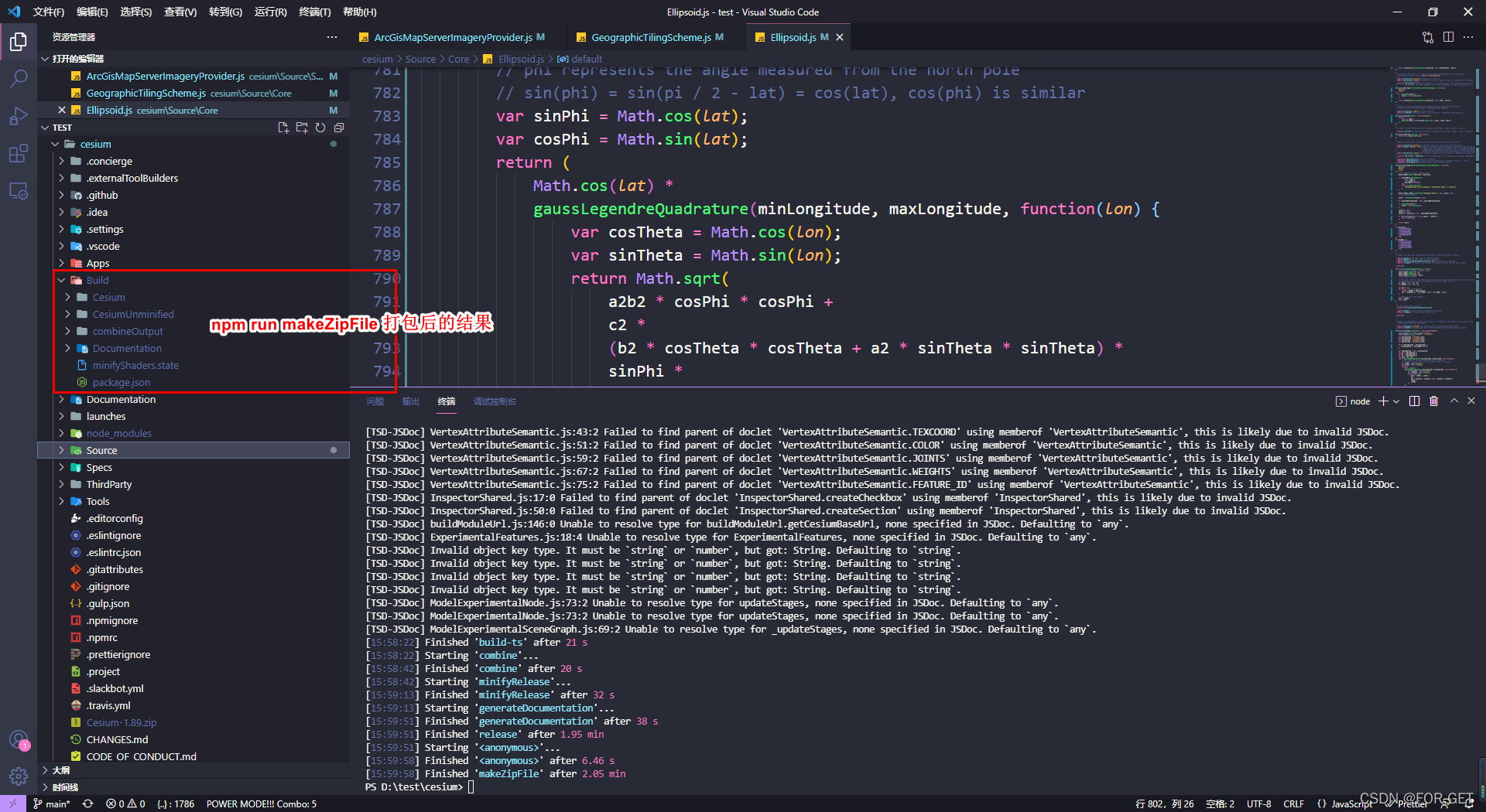
npm run release // [最完整的打包]
// 打包到Build 目录下,包括上线的运行版本,调试版本 和API文档

npm run makeZipFile // [生成分发zip包]*****使用此方式即可
// 打包到根目录下的 Cesium-<版本号>.zip ,删除不必要的开发文件

//打包到Build目录下的Cesium目录
npm run minifyRelease //[线上运行打包]
npm run minify [线上运行留Debug信息打包]

// 打包到Build目录下的CesiumUnminified目录
npm run combine //[不压缩并留Debug信息打包]
npm run combineRelease // [不压缩且不保留Debug信息打包]

// 运行本地帮助文档,示例代码服务
npm start  <--port 可选端口>

// 运行局域网内帮助文档,示例代码服务
npm startPublic
通过git下载,更改源码后打包的结果


 4980
4980


 被折叠的 条评论
为什么被折叠?
被折叠的 条评论
为什么被折叠?
 到【灌水乐园】发言


