


 本文探讨了如何利用深度学习技术对街景图像进行分割,以此进行大规模的城市树木死亡率研究。通过街景图像,研究人员可以分析并评估城市绿化健康状况,为环保提供科学依据。
街景图像分割
Many inventories of street trees are recorded manually by an expert walking through cities and recording each tree with different attributes. This process is obviously expensive and doesn’t scale very well.
专家们在城市中穿行并记录具有不同属性的每棵树,从而手动记录了许多行道树的清单。 这个过程显然很昂贵,而且扩展性很差。
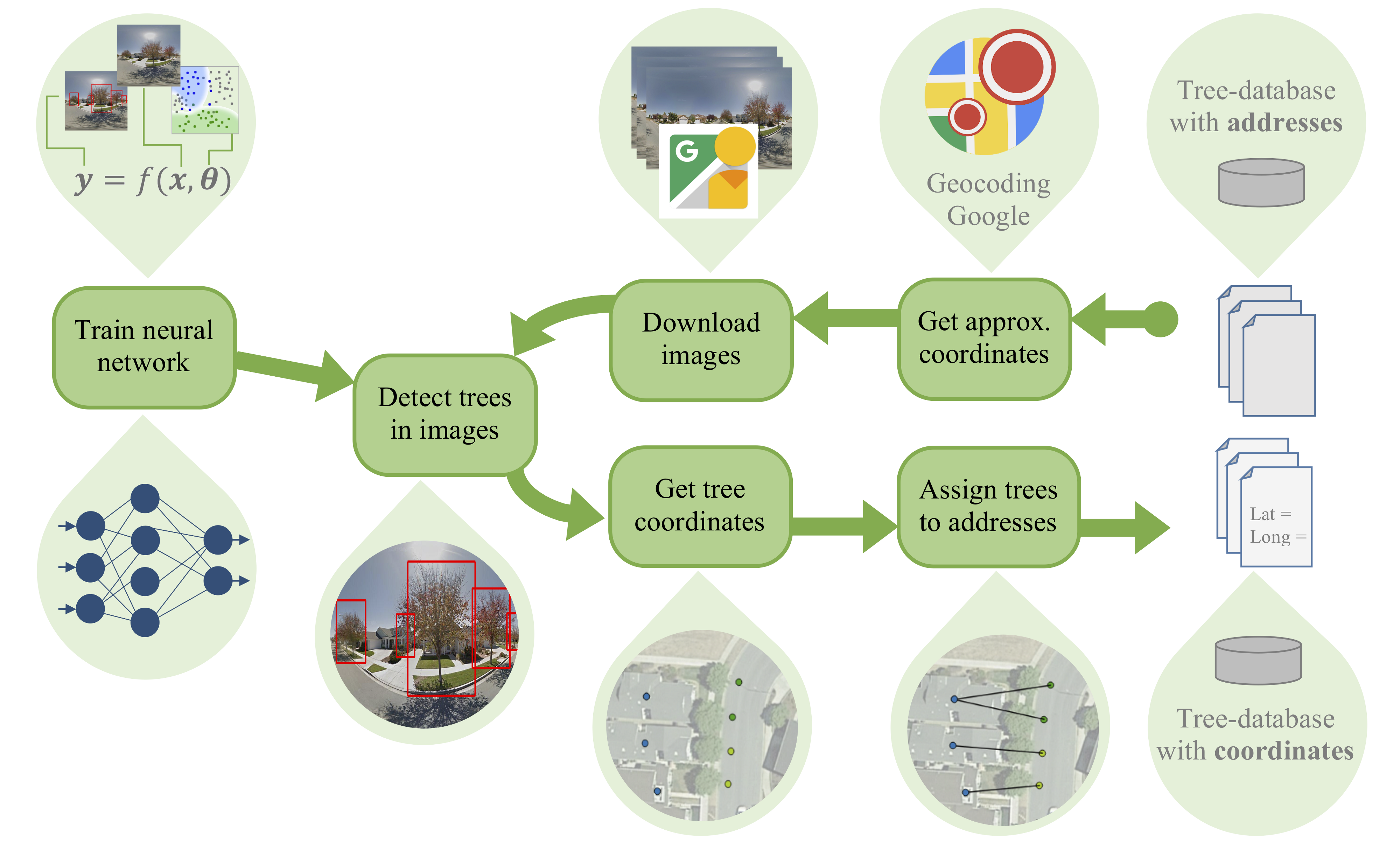
To address this problem, Wegner et al. (2016) proposed a way of automating the creation of urban tree inventories by using a deep learning model that detects and assigns geo-coordinates to trees from Street View images. However, in order to perform long-term tree health studies, with time-series starting before street-level imagery was available, we still rely on these traditional inventories.
为了解决这个问题,Wegner等人。 (2016)提出了一种通过使用深度学习模型自动创建城市树木清单的方法,该模型可以根据街景图像检测并为树木分配地理坐标。 但是,为了进行长期的树木健康研究,我们需要从获得街道级图像之前的时间序列开始, 我们仍然依赖这些传统清单 。
Most of the existing old databases have one crucial deficiency: the tree locations are recorded as street addresses instead of geographic coordinates.
大多数现有的旧数据库都有一个关键缺陷: 将树的位置记录为街道地址,而不是地理坐标。
This makes them much less accurate and harder to use in practice. The goal of our project is to address this challenge: we provide an automated way to assign geo-coordinates to old tree inventories using Street View images.
这使它们的准确性大大降低,在实践中更难使用。 我们项目的目标是解决这一挑战: 我们提供了一种自动方式,可以使用街景视图图像将地理坐标分配给老树清单。
The hope is that our approach on retrofitting existing street tree inventories with geographic coordinates will enable large-scale longitudinal studies, where data of the same population of trees can be analysed over decades.
希望我们采用地理坐标翻新现有街道树木清单的方法将能够进行大规模的纵向研究,在该研究中,可以对数十年内相同树木的数据进行分析。
为什么街上的树木很重要? (Why are street trees important?)
Although street trees make up a small proportion of the urban forest, they provide considerable ecosystem services to the urban landscape. These benefits include for example improvement in air quality, a reduction of the heat island effect and increased carbon capture and storage. Additionally, they can contribute to rising property values and an improvement in individual and community wellbeing.
尽管街头树木仅占城市森林的一小部分,但它们为城市景观提供了可观的生态系统服务。 这些好处包括例如改善空气质量 , 减少热岛效应以及增加碳捕获和储存 。 此外,它们还可以促进财产价值的增长以及个人和社区福祉的改善。
如何解决这样的问题? (How to approach such a problem?)
Our idea: We want to use the existing tool developed by Wegner et al. (2016) to automatically find trees on Street View images and then match them to the trees in the old databases based on their addresses.
我们的想法:我们想使用Wegner等人开发的现有工具。 (2016)自动在街景图像上查找树木,然后根据其地址将其与旧数据库中的树木匹配。
 最低0.47元/天 解锁文章


 2105
2105

 被折叠的 条评论
为什么被折叠?
被折叠的 条评论
为什么被折叠?
 到【灌水乐园】发言


