


 该代码示例展示了如何利用Landsat8数据,通过JavaScript计算NDVI、EVI等植被指数,并在地图上显示时间序列图表。用户可以设定时间范围和云量条件,点击地图点以查看该点的植被指数变化,并导出相关数据。
通过筛选Landsat影像数据,计算相关植被指数(NDVI、EVI等),实现点击某点后显示该时间段内的所有相关植被指数的时间序列图表,并且可以导出相关数据。
(1)运行效果
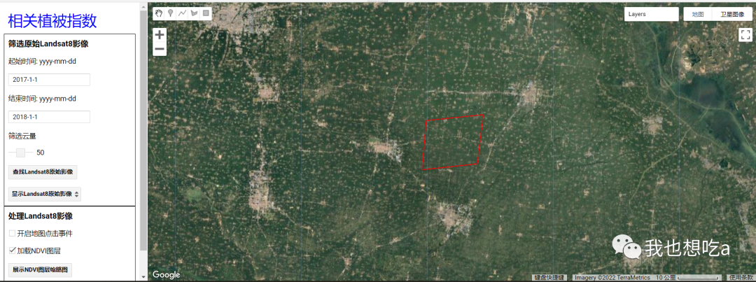
初始化界面
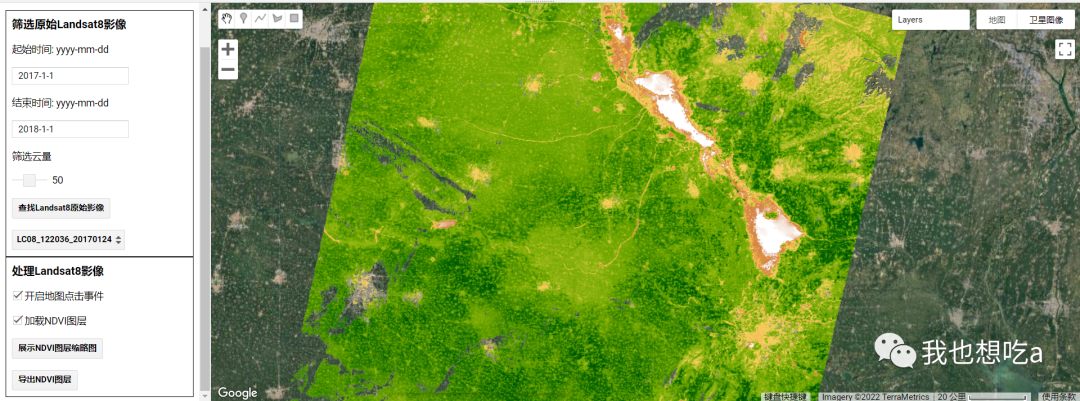
指定条件筛选后界面
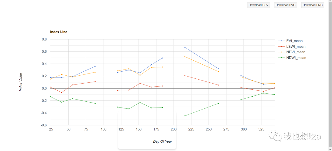
相关植被指数等列表曲线
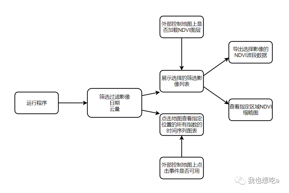
(2)流程分析
(3)代码
var roi = /* color: #009999 */ee.Geometry.Polygon(
        [[[116.01215820312495, 35.01173039395982],
          [116.00117187499995, 34.89917580755738],
          [116.15498046874995, 34.912690517484585],
          [116.17145996093745, 35.025226554463565]]]),
    l8 = ee.ImageCollection("LANDSAT/LC08/C01/T1_TOA");

/**
 * 定义相关常量和变量
 * @type {Object}
 */
var app = {
  data: {
    startDate: "2017-1-1",
    endDate: "2018-1-1",
    cloudScore: 50,
    l8Col: null,
    mapClickFlag: false,
    showNDVILayer: true,
    rawLayer: null,
    ndviLayer: null,
    selectImageKey: null,
    clickPoint: null
  },
  config: {
    ndviVisParam: {
      min: -0.2,
      max: 0.8,
      palette: 'FFFFFF, CE7E45, DF923D, F1B555, FCD163, 99B718, 74A901, 66A000, 529400,' +
        '3E8601, 207401, 056201, 004C00, 023B01, 012E01, 011D01, 011301'
    },
    rgbVisParam: {
      min: 0,
      max: 0.3,
      bands: ["B4", "B3", "B2"]
    }
  },
  ui: {}
};

/**
 * 定义Landsat 8公共方法
 * @type {Object}
 */
var Landsat8 = {
  //NDWI: (B03 - B05)/(B03 + B05)
  NDWI: function(image) {
      return image.addBands(image.normalizedDifference(["B3", "B5"])
          .rename("NDWI"));
  },

  //NDVI: (B05 - B04)/(B05 + B04)
  NDVI: function(img) {
    var ndvi = img.normalizedDifference(["B5","B4"]);
    return img.addBands(ndvi.rename("NDVI"));
  },

  //EVI: 2.5*(B05 - B04) / (B05 + 6*B04 - 7.5*B02 + 1)
  EVI: function(img) {
    var nir = img.select("B5");
    var red = img.select("B4");
    var blue = img.select("B2");
    var evi = img.expression(
      "2.5 * (B5 - B4) / (B5 + 6*B4 - 7.5*B2 + 1)",
      {
        "B5": nir,
        "B4": red,
        "B2": blue
      }
    );
    return img.addBands(evi.rename("EVI"));
  },

  //LSWI: (B05 - B6)/(B06 + B6)
  LSWI: function(img) {
    var lswi = img.normalizedDifference(["B5","B6"]);
    return img.addBands(lswi.rename("LSWI"));
  },

  /**
   * 通过日期、区域、云量筛选数据
   * @param  {[type]} startDate [description]
   * @param  {[type]} endDate   [description]
   * @param  {[type]} region    [description]
   * @param  {[type]} cloud     [description]
   * @return {[type]}           [description]
   */
  getL8ImageCollection : function(startDate, endDate, region, cloud) {
    var dataset = l8.filterDate(startDate, endDate)
                    .filterBounds(region)
                    .map(ee.Algorithms.Landsat.simpleCloudScore)
                    .map(function(image) {
                      return image.updateMask(image.select("cloud").lte(cloud));
                    })
                    .map(Landsat8.NDVI)
                    .map(Landsat8.NDWI)
                    .map(Landsat8.EVI)
                    .map(Landsat8.LSWI);
    return dataset;
  }
};

/**
 * 显示边界
 * @param  {[type]} region [description]
 * @return {[type]}        [description]
 */
function showBounds(region) {
  var outline = ee.Image()
                  .toByte()
                  .paint({
                    featureCollection:region,
                    color:0,
                    width:1.5
                  });
  Map.addLayer(outline, {palette: "ff0000"}, "bounds");
}

/**
 * 导出影像数据
 * @param  {[type]} image    [description]
 * @param  {[type]} region   [description]
 * @param  {[type]} desc     [description]
 * @param  {[type]} fileName [description]
 * @return {[type]}          [description]
 */
function exportImageToDrive(image, region, desc, fileName) {
    Export.image.toDrive({
        image: image,
        description: desc,
        folder: "training01",
        fileNamePrefix: fileName,
        crs: "EPSG:4326",
        region: region,
        scale: 30,
        maxPixels: 1e13
    });
}

/**
 * 地图点击事件
 * @param  {[type]} coords)        {                                print("click map point         is: " + coords.lon + " " + coords.lat);    if (app.data.mapClickFlag) {      var point [description]
 * @param  {[type]} region:point   [description]
 * @param  {[type]} regionReducer: ee.Reducer.mean() [description]
 * @param  {[type]} scale:30                                                      }  [description]
 * @return {[type]}                [description]
 */
Map.onClick(function(coords) {
    print("click map point is: " + coords.lon + " " + coords.lat);
    if (app.data.mapClickFlag) {
      var point = ee.Geometry.Point(coords.lon, coords.lat);
      if (app.data.clickPoint !== null) {
        Map.remove(app.data.clickPoint);
      }
      app.data.clickPoint = null;
      app.data.clickPoint = Map.addLayer(point, {color: "red"}, "clickPoint");
      //normal
      var chart = ui.Chart.image.doySeries({
          imageCollection: app.data.l8Col.select(["NDVI", "EVI", "NDWI", "LSWI"]),
          region:point,
          regionReducer: ee.Reducer.mean(),
          scale:30
      }).setOptions({
        title: "Index Line",
        hAxis: {title: "Day Of Year"},
        vAxis: {title: "Index Value"},
        series: {
          0: { lineWidth: 1, pointSize: 2 },
          1: { lineWidth: 1, pointSize: 2 },
          2: { lineWidth: 1, pointSize: 2 },
          3: { lineWidth: 1, pointSize: 2 }
        }
      });
      print(chart);
    }
  }
);

/**
 * 查找卫星影像
 * @return {[type]} [description]
 */
function searchLandsatImages () {
  app.data.l8Col = Landsat8.getL8ImageCollection(app.data.startDate, app.data.endDate, roi, app.data.cloudScore);
  var l8Ids = app.data.l8Col.reduceColumns(ee.Reducer.toList(), ["system:index"])
                            .get("list");
  l8Ids.evaluate(function(ids) {
    print("select images length is: " + ids.length);
    app.ui.rawImagePanel.select.items().reset(ids);
    app.ui.rawImagePanel.select.setValue(app.ui.rawImagePanel.select.items().get(0));
  });
}

/**
 * 切换卫星影像
 * @param  {[type]} key [description]
 * @return {[type]}     [description]
 */
function showLandsatImage(key) {
  if (app.data.rawLayer !== null) {
    Map.remove(app.data.rawLayer);
  }
  app.data.rawLayer = null;

  if (app.data.ndviLayer !== null) {
    Map.remove(app.data.ndviLayer);
  }
  app.data.ndviLayer = null;

  print("show landsat8 image id is: " + key);
  app.data.selectImageKey = key;
  var image = ee.Image(app.data.l8Col.filter(ee.Filter.eq("system:index", key)).first());
  app.data.rawLayer = Map.addLayer(image, app.config.rgbVisParam, "RGB-"+key);

  if (app.data.showNDVILayer) {
    app.data.ndviLayer = Map.addLayer(image.select("NDVI"), app.config.ndviVisParam, "NDVI-"+key);
  }
}

/**
 * 导出NDVI结果
 * @return {[type]} [description]
 */
function exportNDVIResult() {
  var key = app.data.selectImageKey;
  var image = ee.Image(app.data.l8Col.filter(ee.Filter.eq("system:index", key)).first());
  var ndvi = image.select("NDVI");
  exportImageToDrive(image, roi, key, key);
}

/**
 * 展示NDVI缩略图
 * @return {[type]} [description]
 */
function showNDVIThumbnail() {
  var key = app.data.selectImageKey;
  var image = ee.Image(app.data.l8Col.filter(ee.Filter.eq("system:index", key)).first());
  var thumbnail = ui.Thumbnail({
    image: image.select("NDVI").visualize(app.config.ndviVisParam),
    params: {
      dimensions: "256x256",  //缩略图大小
      // region: roi.toGeoJSON(), //地理信息
      region: roi, //也可以直接设置为geometry
      format: "png"  //缩略图图片格式
    },
    //显示内容宽和高
    style: {height: "300px", width: "300px"},
    //点击缩略图触发事件
    onClick: function() {
      print("click thumbnail");
    }
  });
  print(thumbnail);
}

/***
 * 初始化UI界面
 * */
function initUI() {

  app.ui = {};
  /
  app.ui.titlePanel = {
    panel: ui.Panel({
      widgets: [
        ui.Label({
          value: "相关植被指数",
          style: {
            color: "0000ff",
            fontSize: "30px"
          }
        })
      ]
    })
  };

  /
  var rawImageTitle = ui.Label({
    value:"筛选原始Landsat8影像",
    style: {
      fontWeight: "bold",
      fontSize: "16px"
    }
  });
  var startLabel = ui.Label("起始时间: yyyy-mm-dd");
  var startTextbox = ui.Textbox({
    placeholder: "起始时间: yyyy-mm-dd",
    value: app.data.startDate,
    onChange: function(value) {
      print("录入的起始时间: " + value);
      app.data.startDate = value;
    }
  });

  var endLabel = ui.Label("结束时间: yyyy-mm-dd");
  var endTextbox = ui.Textbox({
    placeholder: "结束时间: yyyy-mm-dd",
    value: app.data.endDate,
    onChange: function(value) {
      print("录入的结束时间: " + value);
      app.data.endDate = value;
    }
  });

  var cloudLabel = ui.Label("筛选云量");
  var cloudSlider = ui.Slider({
    min:1,
    max:100,
    value:app.data.cloudScore,
    step:1,
    direction: "horizontal",
    onChange: function(value) {
      print("slider1 change value is:"+ value);
      app.data.cloudScore = parseInt(value, 10);
    }
  });

  var searchBtn = ui.Button({
    label: "查找Landsat8原始影像",
    onClick: searchLandsatImages
  });

  var showImages = ui.Select({
    items: [],
    placeholder: "显示Landsat8原始影像",
    onChange: showLandsatImage
  });

  app.ui.rawImagePanel = {
    panel: ui.Panel({
      widgets: [
        rawImageTitle,
        startLabel, startTextbox,
        endLabel, endTextbox,
        cloudLabel, cloudSlider,
        searchBtn,
        showImages
      ],
      style: {
        border : "1px solid black"
      }
    }),
    select: showImages
  };

  /
  var processTitle = ui.Label({
    value:"处理Landsat8影像",
    style: {
      fontWeight: "bold",
      fontSize: "16px"
    }
  });
  var mapClickCB = ui.Checkbox("开启地图点击事件", app.data.mapClickFlag);
  mapClickCB.onChange(function(checked){
    print("地图点击事件:" + checked);
    app.data.mapClickFlag = checked;
  });

  var showNDVICB = ui.Checkbox("加载NDVI图层", app.data.showNDVILayer);
  showNDVICB.onChange(function(checked){
    print("加载NDVI图层:" + checked);
    app.data.showNDVILayer = checked;
  });

  var showThumbnailBtn = ui.Button({
    label: "展示NDVI图层缩略图",
    onClick: showNDVIThumbnail
  });

  var exportNDVIBtn = ui.Button({
    label: "导出NDVI图层",
    onClick: exportNDVIResult
  });


  app.ui.processPanel = {
    panel: ui.Panel({
      widgets: [
        processTitle,
        mapClickCB,
        showNDVICB,
        showThumbnailBtn,
        exportNDVIBtn
      ],
      style: {
        border : "1px solid black"
      }
    })
  };


  var main = ui.Panel({
      widgets: [
        app.ui.titlePanel.panel,
        app.ui.rawImagePanel.panel,
        app.ui.processPanel.panel
      ],
      style: {width: "300px", padding: '8px'}
    });
  ui.root.insert(0, main);
}

/***
 *
 * main
 * */
function main() {
  Map.style().set('cursor', 'crosshair');
  Map.centerObject(roi, 10);
  Map.setOptions("SATELLITE");

  initUI();
  showBounds(roi);
}

main();


 995
995

 被折叠的 条评论
为什么被折叠?
被折叠的 条评论
为什么被折叠?
 到【灌水乐园】发言


