


1. 概述
主要阅读的文章包括:
- Ma, L., et al. 2019. Deep learning in remote sensing applications: A meta-analysis and review. Isprs Journal of Photogrammetry Remote Sensing, 152, 166-177.【高引780】
- Minaee, S., et al. 2021. Image segmentation using deep learning: A survey. IEEE Transactions on Pattern Analysis Machine Intelligence.【高引666】
- Kotaridis, I. and Lazaridou, M. 2021. Remote sensing image segmentation advances: A meta-analysis. Isprs Journal of Photogrammetry Remote Sensing, 173, 309-322.【应用17】
2. Ma, L., et al. 2019. Deep learning in remote sensing applications: A meta-analysis and review. Isprs Journal of Photogrammetry Remote Sensing, 152, 166-177.
文章出发点
前人聚焦在了一些relatively uncommon sub-areas of the remote sensing field,然而忽略了more common sub-areas。
Zhu et al. (2017) performed a broader review than others, but they focused on some relatively uncommon sub-areas of the remote sensing field (e.g., 3D modeling applications) while ignoring many other deserving (and more common) sub-areas; e.g., image classification applications.
所以一篇更定量化、更综合的系统性文章需要形成。
A more systematic (i.e. quantitative) analysis is necessary to get a comprehensive and objective understanding of the applications of DL for remote-sensing analysis.
2.1 文章整体结构
algorithmic networks
- the supervised CNN
- recurrent neural network (RNN) models
- unsupervised autoencoders (AE)
- deep belief networks (DBN) models
- generative adversarial networks (GAN) model
- restricted Boltzmann machine (RBM)
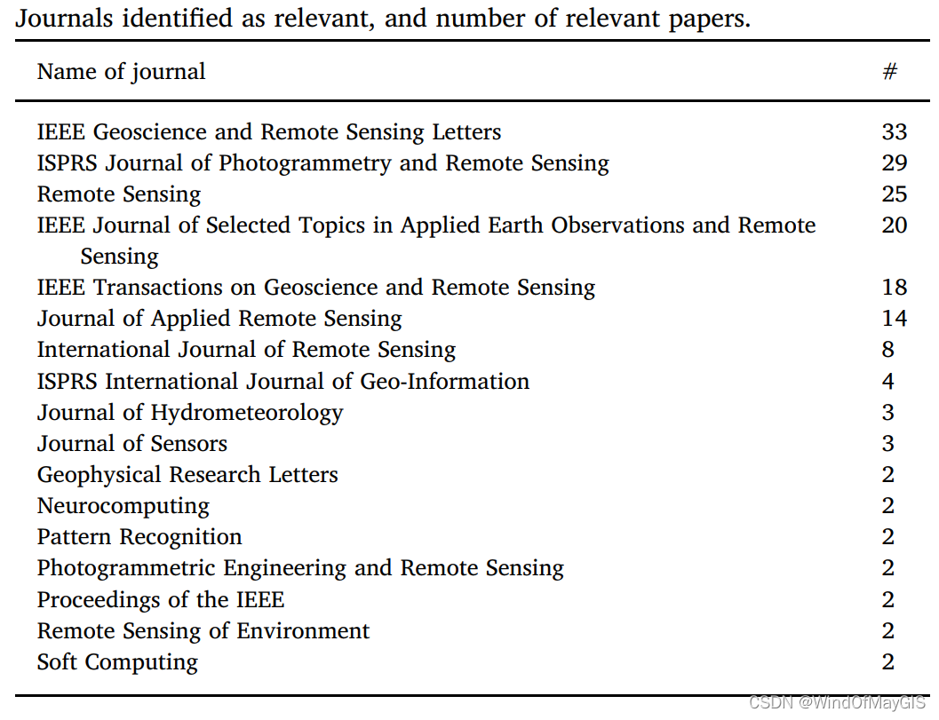
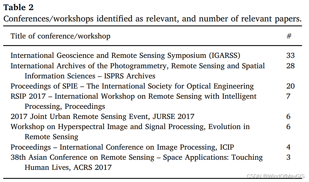
主流期刊与会议
remote sensing image analysis tasks including
- image fusion
Aim to obtain an image that simultaneously has high spectral and spatial resolutions.
① MS and PAN image fusion (pan-sharpening) which indicates the fusion of a low-resolution multi-spectral (MS) image and a high-resolution panchromatic (PAN) image to achieve a high-resolution MS image(pan-sharpening将原始的多光谱(MS)图像和全色(PAN)图像进行融合获得高分辨率多光谱图像的一种方法)。
其他参考:https://blog.csdn.net/weixin_42166578/article/details/104238088
② HS and MS image fusion method
③ HS and MS image fusion method - image registration
Image registration is a method of aligning two or more images captured by different sensors, at different times or from different viewpoints (Zitova & Flusser, 2003; Ye et al., 2017).
多源图像间在几何上是相互配准的,多源遥感图像之间的同名点的确定是图像配准的关键。 - scene classification
In this study, scene classification is defined as a procedure to determine the image categories from numerous pictures—for example, agricultural scenes, forest scenes, and beach scenes (Zou et al., 2015)—and the training samples are a series of labeled pictures. - object detection
Object detection aims to detect different objects in a single image scene — for example, airplanes (Zhong et al., 2018), cars (Ding et al., 2018), and urban villages (Li et al., 2017b) — and the training samples are the pixels in a fixed-sized window or patch.
难点
Therefore, how to design the effective algorithms to overcome the difficulties emerging from different-scale objects (the different type of objects often appears at different scales in remote-sensing images, and also the same object can have variable size in different-scale remotesensing images) is an urgent problem in both subfields (Deng et al., 2018). - use and land cover (LULC) classification,
- segmentation,
- object-based image analysis (OBIA).

2.2 专业词汇
- hyper-spectral (HS) image
- multi-spectral (MS) image
- high-resolution panchromatic (PAN) image
- 样本增强
generate augmented data
augmentation techniques
Yu et al. (2017) applied three operations (flip, translation, and rotation) to generate augmented data and obtain a more descriptive deep model by using these augmented data as training data. - UVA影像的超高分辨率特征
ultra-high-resolution characteristics of unmanned aerial vehicles (UAVs) - 具有地理标识的照片
geotagged photos - 具有识别能力的目标函数
a new discriminative objective function - 遥感数据集体量
the volumes of available remote-sensing datasets - 高分遥感场景分类
VHR remote sensing scene classification - 子领域
subfield
2.3 精句
- 场景分类的高精度特性是优势之一
For example, typically the application of a scene classification technique to the accuracy assessment of remotesensing image classification is advantageous, as pointed out by Xing et al. (2018b). - 降低人力,适用于大范围区域
This method can significantly reduce the complexity and labor required for the conventional validation process, particularly for the validation of classification results of land cover within the given scope of a large area. - 很多研究更倾向于目标检测研究而不是场景分类研究
As mentioned above, we found that current studies preferred to extract certain specific type(s) of objects (airplanes, cars, etc.) from high-resolution images through a fixed window size, either through scene classification. - 洪水、盐碱化、干旱、人为建设、地质灾害对耕地的保护带来了巨大的冲击。
salinity and drought threats
2.4 模糊概念
3. Minaee, S., et al. 2021. Image segmentation using deep learning: A survey. IEEE Transactions on Pattern Analysis Machine Intelligence
3.1 文章整体结构
3.2 关键词
3.3 关键句
3.4 模糊概念
4. Kotaridis, I. and Lazaridou, M. 2021. Remote sensing image segmentation advances: A meta-analysis. Isprs Journal of Photogrammetry Remote Sensing, 173, 309-322.
4.1 文章整体结构
-
segmentation algorithm
-
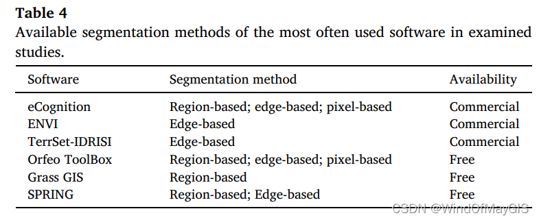
the software utilized
-
the data source
https://github.com/chinawindofmay/PaddleRS/blob/develop/docs/data/dataset_summary.md
4.2 关键词
4.3 关键句
- OBIA includes two principal steps, image segmentation and object classification.
- 地理学第一定律在遥感领域同样也是适用的
This statement makes sense if we consider the first law of Geography, ’Everything is related to everything else. But near things are more related than distant things.’, that was established by Tobler in 1969. This idea applies to numerous phenomena, including
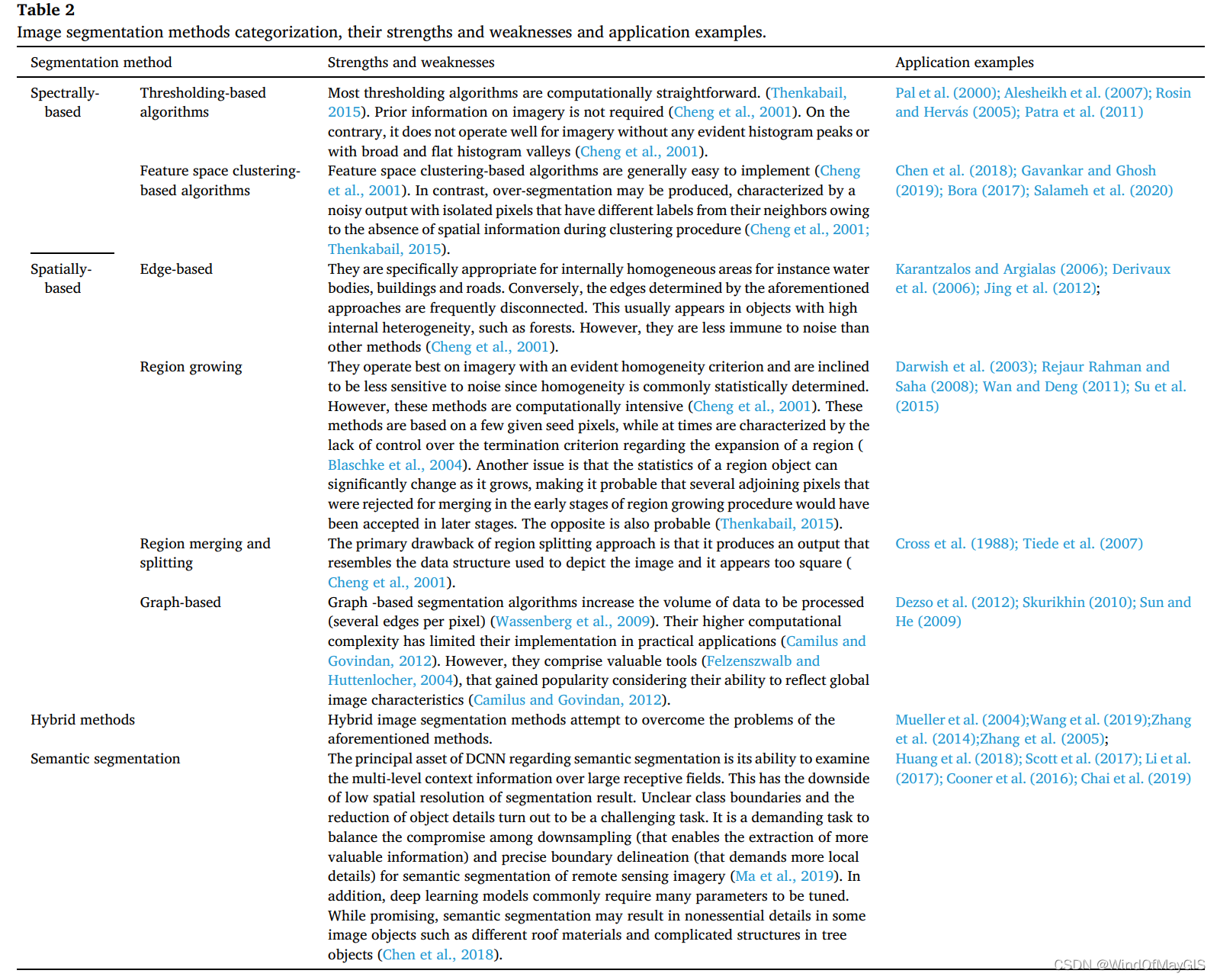
remote sensing applications. - Image segmentation 的起源和发展与3种分类(同质分割、连接分割、图形分割)
Image segmentation is not new, considering that it was established in the 1980 s and 1990s, with various segmentation algorithms available (Thenkabail, 2015). Segmentation algorithms are based on three fundamental criteria to cluster pixels into groups: the homogeneity within a segment, the differentiation from adjoining segments and shape homogeneity (Nussbaum and Menz, 2008). - 影像分割的定义
A common image analysis target of image segmentation is to successfully partition a remote sensing imagery into distinct earth surface regions and produce a labelled map.


 314
314


 被折叠的 条评论
为什么被折叠?
被折叠的 条评论
为什么被折叠?
 到【灌水乐园】发言


