Cesium空间分析-填挖方计算(地形、模型通用)

我的第一篇文章Cesium空间分析-填挖方计算
中,介绍了通过细化PolygonGeometry的颗粒度,进行填挖方计算。这里还是要感谢大神的分享

这个思路,简单、清晰。但是有一个弊端-无法在模型上进行填挖方分析。

今天我用Cesium+turf.fs结合的方式,实现了一版地形、模型通用的填挖方分析方法。


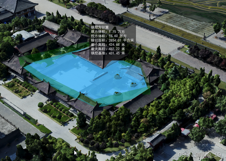
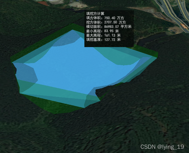
思路:基于表面面积量算的实现思路,对范围面进行细化。

细化方法:对范围面对应的屏幕坐标范围生成泰森多边形。
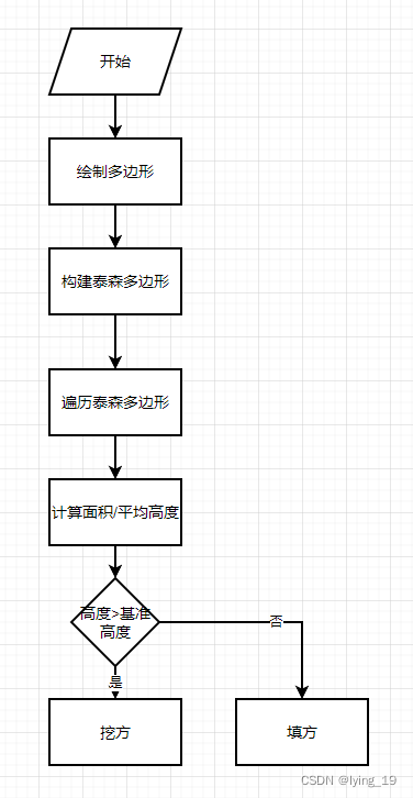
实现流程:

 实现代码:

 private computeCutAndFillVolumeVoronoi(positions:Cesium.Cartesian3[]):CutAndFillResult{
        const result = new CutAndFillResult();
        //声明屏幕坐标数组
        const windowPositions:Cesium.Cartesian2[]=[];
        //先遍历一下多边形节点,获取最低高程点,作为基准高程
        //同时将Cartesian3转为屏幕坐标,存放在数组中
        positions.forEach(element => {
            const cartographic = Cesium.Cartographic.fromCartesian(element);
            this.baseHeight = Math.min(cartographic.height,this.baseHeight);
            windowPositions.push(Cesium.SceneTransforms.wgs84ToWindowCoordinates(this.viewer.scene,element));
        }) 
        //构建泰森多边形的过程
        const bounds = getBounds(windowPositions);
        const points = turf.randomPoint(50,{bbox:[bounds[0],bounds[1],bounds[2],bounds[3]]});
        const mainPoly = Cartesian2turfPolygon(windowPositions);
        const voronoiPolygons = turf.voronoi(points,{bbox:[bounds[0],bounds[1],bounds[2],bounds[3]]});

        //遍历泰森多边形
        voronoiPolygons.features.forEach(element => {
            const intersectPoints = intersect(mainPoly,element.geometry);
            if(intersectPoints.length > 0){
                //计算每个多边形的面积和高度
                const cubeInfo = this.computeCubeInfo(intersectPoints);
                //低于基准面,填方
                if(this.baseHeight> cubeInfo.avgHeight){
                    result.fillVolume += (this.baseHeight - cubeInfo.avgHeight) * result.baseArea; 
                }else{ //高于基准面,挖方
                    result.cutVolume += (cubeInfo.avgHeight -this.baseHeight) *result.baseArea;
                }
                result.maxHeight = Math.max(result.maxHeight,cubeInfo.maxHeight);
                result.minHeight = Math.min(result.minHeight,cubeInfo.minHeight);
                result.baseArea += cubeInfo.baseArea;
            }
        });
        return result;
    }

 private computeCubeInfo(positions:Cesium.Cartesian2[]){
        let worldPositions:Cesium.Cartographic[] = [];
        let minHeight = Number.MAX_VALUE;
        let maxHeight = Number.MIN_VALUE;
        let sumHeight = 0.0;
        positions.forEach(element => {
            const worldPostion = pickCartesian(this.viewer,element).cartesian;
            const cartographic = Cesium.Cartographic.fromCartesian(worldPostion);
            worldPositions.push(cartographic);
            minHeight = Math.min(minHeight,cartographic.height);
            maxHeight = Math.max(maxHeight,cartographic.height);
            sumHeight += cartographic.height;
        });
        const avgHeight = sumHeight/positions.length;
        const result = new CubeInfo();
        result.minHeight = minHeight;
        result.maxHeight = maxHeight;
        result.avgHeight = avgHeight;
        result.baseArea = getAreaFromCartograohics(worldPositions);
        return result;
    }

export function getBounds(points:Cesium.Cartesian2[]):number[]{
    let bounds: number[] = [];
    let left = Number.MAX_VALUE;
    let right = Number.MIN_VALUE;
    let top = Number.MAX_VALUE;
    let bottom = Number.MIN_VALUE;
    points.forEach(element => {
        left = Math.min(left,element.x);
        right = Math.max(right,element.x);
        top = Math.min(top,element.y);
        bottom = Math.max(bottom,element.y);
    });
    bounds.push(left);
    bounds.push(top);
    bounds.push(right);
    bounds.push(bottom);
    return bounds;
}


export function Cartesian2turfPolygon(positions:Cesium.Cartesian2[]):turf.helpers.Polygon{
    var coordinates:number[][][] = [[]];
    positions.forEach(element => {
        coordinates[0].push([element.x,element.y]);
    });
    coordinates[0].push([positions[0].x,positions[0].y]);
    const polygon =  turf.polygon(coordinates);
    return polygon.geometry;
}

export function turfPloygon2CartesianArr(geometry:turf.Polygon):Cesium.Cartesian2[]{
  const positionArr:Cesium.Cartesian2[] = [];
  geometry.coordinates.forEach((pointArr: any[]) => {
    pointArr.forEach(point => {
      positionArr.push(new Cesium.Cartesian2(point[0],point[1]));
    });
  });
  positionArr.push(new Cesium.Cartesian2(geometry.coordinates[0][0][0],geometry.coordinates[0][0][1]));
  return positionArr;
}

export function intersect(poly1:turf.helpers.Polygon,poly2:turf.helpers.Polygon):Cesium.Cartesian2[]{
    var intersection = turf.intersect(poly1, poly2);
    if(intersection?.geometry !== undefined){
        return turfPloygon2CartesianArr(intersection?.geometry as turf.Polygon);
    }else{
        return [];
    }
}

export function getAreaFromCartograohics(positions:Cartographic[]):number{
    const x: number[] = [0];
    const y: number[] = [0];
    const geodesic = new Cesium.EllipsoidGeodesic();
    const radiansPerDegree = Math.PI / 180.0; //角度转化为弧度(rad)
    //数组x,y分别按顺序存储各点的横、纵坐标值
    for (let i = 0; i < positions.length - 1; i++) {
      const p1 = positions[i];
      const p2 = positions[i + 1];
      geodesic.setEndPoints(p1, p2);
    //   const s = Math.sqrt(Math.pow(geodesic.surfaceDistance, 2) +
    //     Math.pow(p2.height - p1.height, 2));
      const s = Math.sqrt(Math.pow(geodesic.surfaceDistance, 2));
      // console.log(s, p2.y - p1.y, p2.x - p1.x)
      const lat1 = p2.latitude * radiansPerDegree;
      const lon1 = p2.longitude * radiansPerDegree;
      const lat2 = p1.latitude * radiansPerDegree;
      const lon2 = p1.longitude * radiansPerDegree;
      let angle = -Math.atan2(
        Math.sin(lon1 - lon2) * Math.cos(lat2),
        Math.cos(lat1) * Math.sin(lat2) - Math.sin(lat1) * Math.cos(lat2) * Math.cos(lon1 - lon2)
      );
      if (angle < 0) {
        angle += Math.PI * 2.0;
      }
      console.log('角度:' + (angle * 180) / Math.PI);

      y.push(Math.sin(angle) * s + y[i]);
      x.push(Math.cos(angle) * s + x[i]);
    }

    let sum = 0;
    for (let i = 0; i < x.length - 1; i++) {
      sum += x[i] * y[i + 1] - x[i + 1] * y[i];
    }
    // console.log(x, y)

    return Math.abs(sum + x[x.length - 1] * y[0] - x[0] * y[y.length - 1]) / 2;
}

export class CutAndFillResult {
    minHeight:number = Number.MAX_VALUE;
    maxHeight:number = Number.MIN_VALUE;
    cutVolume:number = 0.0;
    fillVolume:number = 0.0;
    baseArea:number = 0.0;
}

export class CubeInfo{
    minHeight:number = Number.MAX_VALUE;
    maxHeight:number = Number.MIN_VALUE;
    avgHeight:number = 0.0;
    baseArea:number = 0.0;
}
    
export class PickResult {
  cartesian!: Cesium.Cartesian3
  cartesianTerrain!: Cesium.Cartesian3
  CartesianModel!: Cesium.Cartesian3
  windowCoordinates!: Cesium.Cartesian2
  altitudeMode = Cesium.HeightReference.NONE
}

  • 9
    点赞
  • 43
    收藏
    觉得还不错? 一键收藏
  • 24
    评论
Cesium挖方计算是指使用Cesium软件进行土方工程量计算的过程。土方工程量计算是土建工程中常见的一项任务,通过计算方和挖方的体积,可以确定工程所需的土方量。 Cesium软件是一种基于地理信息系统(GIS)的软件,可以进行地形分析和土方计算。首先,我们需要将工程现场的地形数据输入到Cesium软件中,这些数据可以通过地面测量仪或航空摄影测量获得。 然后,根据工程的要求和设计,我们可以使用Cesium软件中的工具来确定方和挖方的区域。方是指在工程进展中需要将土方到某个区域,而挖方是指在工程进展中需要将土方从某个区域挖出。 Cesium软件会根据输入的地形数据和工程要求,自动计算方和挖方的体积。它会以数字和图形方式显示方和挖方的区域,并给出相应的体积数据。同时,Cesium软件还能够生成2D和3D的土方图和工程量表,方便工程师进行详细的分析和规划。 通过Cesium挖方计算,我们可以准确地确定土方工程的量,有助于合理安排工程进度、成本控制和资源配置。这不仅提高了工程效率,还降低了工程风险,保证了施工的顺利进行。 总之,Cesium挖方计算是一种通过使用Cesium软件进行土方工程量计算的过程,它可以帮助工程师准确计算方和挖方的体积,规划土方工程,提高工程效率和质量。

“相关推荐”对你有帮助么?

  • 非常没帮助
  • 没帮助
  • 一般
  • 有帮助
  • 非常有帮助
提交
评论 24
添加红包

请填写红包祝福语或标题

红包个数最小为10个

红包金额最低5元

当前余额3.43前往充值 >
需支付:10.00
成就一亿技术人!
领取后你会自动成为博主和红包主的粉丝 规则
hope_wisdom
发出的红包
实付
使用余额支付
点击重新获取
扫码支付
钱包余额 0

抵扣说明:

1.余额是钱包充值的虚拟货币,按照1:1的比例进行支付金额的抵扣。
2.余额无法直接购买下载,可以购买VIP、付费专栏及课程。

余额充值