


RRT_Star结合OMPL实现三维点云的路径规划
文章目录
OMPL中文名为最优规划,比如 R R T ∗ RRT^{\ast} RRT∗。采用OMPL为基本框架,在三维点云中实现 R R T ∗ RRT^{\ast} RRT∗算法。
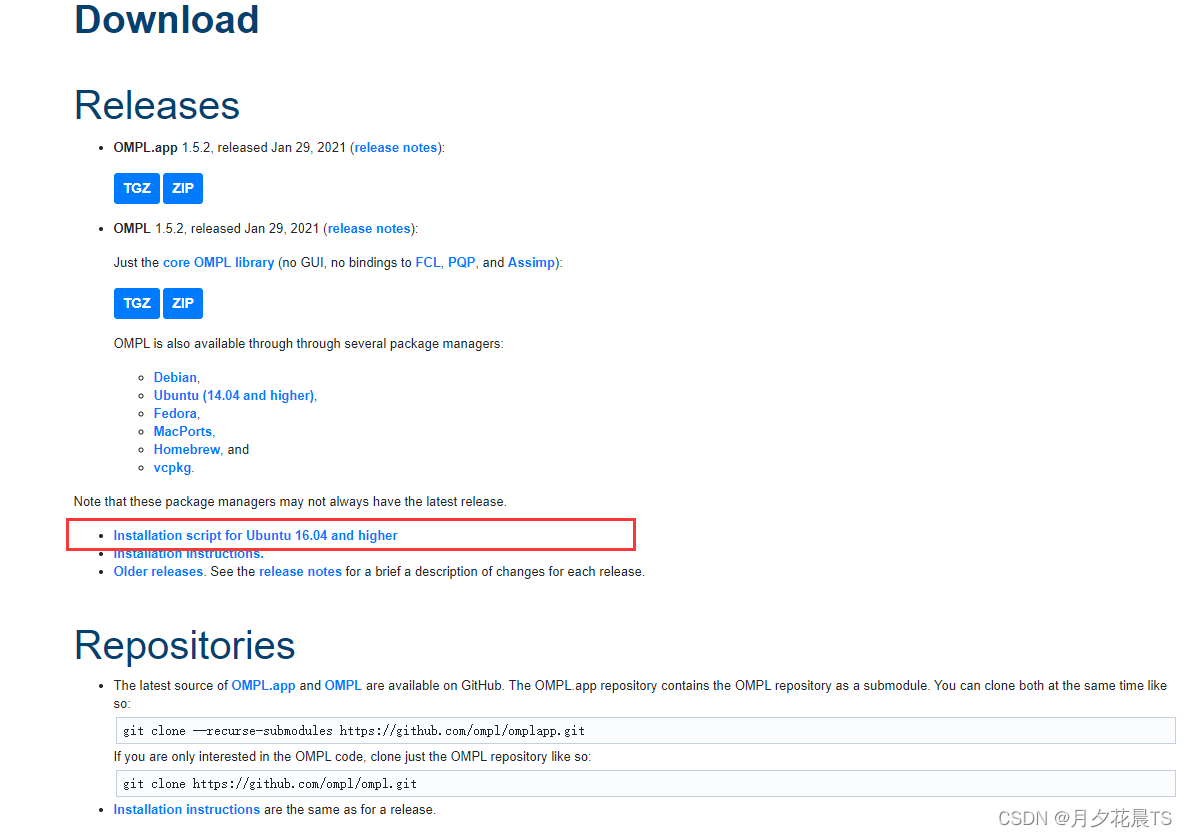
1.OMPL安装
网址:https://ompl.kavrakilab.org/download.html
推荐使用脚本安装,下载脚本后
sudo chmod 777 install-ompl-ubuntn.sh
./install-ompl-ubuntn.sh
注意:1.如果在安装脚本的过程中,需要下载ros中的一些东西,此时最好在安装角本前,更换ros源。 ros源更换参考:ROS换源(除了清华之外的ROS源)
ROS wiki
2.安装ompl可能会出现电脑分辨率的发生变化,并且此时会弹出Patch the file(我记得是这样),此时先不要管,一路回车即可。最终再在电脑设置中更改分辨率。
2.OMPL使用
2.1创建机器人的状态空间
因为是在有限点云空间中进行路径规划,因此机器人的状态空间为3,其次需要为空间设置一个边界。
ob::StateSpacePtr space(new ob::RealVectorStateSpace(3));

//将空间的边界设置为[0,1]。
ob::RealVectorBounds bounds(3);
bounds.setLow(0, - _x_size * 0.5);
bounds.setLow(1, - _y_size * 0.5);
bounds.setLow(2, 0.0);

bounds.setHigh(0, + _x_size * 0.5);
bounds.setHigh(1, + _y_size * 0.5);
bounds.setHigh(2, _z_size);
space->as<ob::RealVectorStateSpace>()->setBounds(bounds);
2.2 构造一个空间实例
ob::SpaceInformationPtr si(new ob::SpaceInformation(space));
//设置用于检查空间中哪些状态有效的对象
si->setStateValidityChecker(ob::StateValidityCheckerPtr(new ValidityChecker(si)));
si->setup();
其中ValidityChecker为自定义的类,目的时继承ompl下的StateValidityChecker,并重写有效性函数isValid(ompl无法对该点状态做有效性(安全性)判断)。
class ValidityChecker : public ob::StateValidityChecker
{
public:
    ValidityChecker(const ob::SpaceInformationPtr& si) :ob::StateValidityChecker(si) {}
    //返回给定状态的位置是否与圆形障碍物重叠
    bool isValid(const ob::State* state) const
    {
        //在本例中使用的是RealVectorStateSpace,因此需要将状态转换为特定类型。
        const ob::RealVectorStateSpace::StateType* state3D =state->as<ob::RealVectorStateSpace::StateType>();
        auto x=(*state3D)[0];
        auto y=(*state3D)[1];
        auto z=(*state3D)[2];
        return _RRTstar_preparatory->isObsFree(x, y, z);
    }
};
2.3 创建问题实例,并设置一些参数
auto pdef(std::make_shared<ob::ProblemDefinition>(si));
//设置开始和目标状态
pdef->setStartAndGoalStates(start, goal);
//设置优化目标
pdef->setOptimizationObjective(getPathLengthObjective(si));
其中getPathLengthObjective函数为自定义函数,目的是为ompl提供优化阈值。如果阈值为0.0,表示希望能够找到最好的路线,不设置默认为0.0。阈值通过**obj->setCostThreshold(ob::Cost())**进行设置。
ob::OptimizationObjectivePtr getPathLengthObjective(const ob::SpaceInformationPtr& si)
{
     ob::OptimizationObjectivePtr obj(new ob::PathLengthOptimizationObjective(si));
     #obj->setCostThreshold(ob::Cost(1.51));
     return obj;
}
2.4 构建优化器
使用RRT算法构建优化器
ob::PlannerPtr optimizingPlanner(new og::RRTstar(si));
optimizingPlanner->setProblemDefinition(pdef);
optimizingPlanner->setup();
2.5 ompl进行求解
其中参数1.0表示希望在1s中得出路径规划结果
ob::PlannerStatus solved = optimizingPlanner->solve(1.0);
2.6 ompl路径生成
if (solved)
{
    //从问题定义中获取目标表示(与目标状态不同),并查询找到的路径
    og::PathGeometric* path = pdef->getSolutionPath()->as<og::PathGeometric>();
    vector<Vector3d> path_points;
    for (size_t path_idx = 0; path_idx < path->getStateCount (); path_idx++)
    {
        const ob::RealVectorStateSpace::StateType *state = path->getState(path_idx)->as<ob::RealVectorStateSpace::StateType>();
        auto x = (*state)[0];
        auto y = (*state)[1];
        auto z = (*state)[2];
        Vector3d temp_mat(x,y,z);
        path_points.push_back(temp_mat);
    }
}
3.整体代码展示
3.1 代码框架修改
在章的基础上进行修改,修改如下
在src文件夹下,新建rrt.cpp,rrt_demo.cpp
在include文件夹下,新建rrt.h
在launch文件夹下,新建rrt_demo.launch
修改CMakeLists.txt内容
3.1.1 rrt.h
#ifndef _GRID_SEARCHER_H_
#define _GRID_SEARCHER_H_

#include <iostream>
#include <ros/ros.h>
#include <ros/console.h>
#include <Eigen/Eigen>
#include "backward.hpp"
#include "node.h"

class RRTstarPreparatory
{
	private:

	protected:
		uint8_t * data;
		GridNodePtr *** GridNodeMap;

		int GLX_SIZE, GLY_SIZE, GLZ_SIZE;
		int GLXYZ_SIZE, GLYZ_SIZE;

		double resolution, inv_resolution;
		double gl_xl, gl_yl, gl_zl;
		double gl_xu, gl_yu, gl_zu;

		Eigen::Vector3d gridIndex2coord(const Eigen::Vector3i & index);
		Eigen::Vector3i coord2gridIndex(const Eigen::Vector3d & pt);

	public:
		RRTstarPreparatory(){};
		~RRTstarPreparatory(){};

		void initGridMap(double _resolution, Eigen::Vector3d global_xyz_l, Eigen::Vector3d global_xyz_u, int max_x_id, int max_y_id, int max_z_id);
		void setObs(const double coord_x, const double coord_y, const double coord_z);
		bool isObsFree(const double coord_x, const double coord_y, const double coord_z);

		Eigen::Vector3d coordRounding(const Eigen::Vector3d & coord);
};
#endif
3.1.2 rrt.cpp
#include <rrt.h>

using namespace std;
using namespace Eigen;

void RRTstarPreparatory::initGridMap(double _resolution, Vector3d global_xyz_l, Vector3d global_xyz_u, int max_x_id, int max_y_id, int max_z_id)
{
    gl_xl = global_xyz_l(0);
    gl_yl = global_xyz_l(1);
    gl_zl = global_xyz_l(2);

    gl_xu = global_xyz_u(0);
    gl_yu = global_xyz_u(1);
    gl_zu = global_xyz_u(2);

    GLX_SIZE = max_x_id;
    GLY_SIZE = max_y_id;
    GLZ_SIZE = max_z_id;
    GLYZ_SIZE  = GLY_SIZE * GLZ_SIZE;
    GLXYZ_SIZE = GLX_SIZE * GLYZ_SIZE;

    resolution = _resolution;
    inv_resolution = 1.0 / _resolution;

    data = new uint8_t[GLXYZ_SIZE];
    memset(data, 0, GLXYZ_SIZE * sizeof(uint8_t));
}

void RRTstarPreparatory::setObs(const double coord_x, const double coord_y, const double coord_z)
{
    if( coord_x < gl_xl  || coord_y < gl_yl  || coord_z <  gl_zl ||
        coord_x >= gl_xu || coord_y >= gl_yu || coord_z >= gl_zu )
        return;

    int idx_x = static_cast<int>( (coord_x - gl_xl) * inv_resolution);
    int idx_y = static_cast<int>( (coord_y - gl_yl) * inv_resolution);
    int idx_z = static_cast<int>( (coord_z - gl_zl) * inv_resolution);

    data[idx_x * GLYZ_SIZE + idx_y * GLZ_SIZE + idx_z] = 1;
}

bool RRTstarPreparatory::isObsFree(const double coord_x, const double coord_y, const double coord_z)
{
    Vector3d pt;
    Vector3i idx;

    pt(0) = coord_x;
    pt(1) = coord_y;
    pt(2) = coord_z;
    idx = coord2gridIndex(pt);

    int idx_x = idx(0);
    int idx_y = idx(1);
    int idx_z = idx(2);

    return (idx_x >= 0 && idx_x < GLX_SIZE && idx_y >= 0 && idx_y < GLY_SIZE && idx_z >= 0 && idx_z < GLZ_SIZE &&
           (data[idx_x * GLYZ_SIZE + idx_y * GLZ_SIZE + idx_z] < 1));
}

Vector3d RRTstarPreparatory::gridIndex2coord(const Vector3i & index)
{
    Vector3d pt;

    pt(0) = ((double)index(0) + 0.5) * resolution + gl_xl;
    pt(1) = ((double)index(1) + 0.5) * resolution + gl_yl;
    pt(2) = ((double)index(2) + 0.5) * resolution + gl_zl;

    return pt;
}

Vector3i RRTstarPreparatory::coord2gridIndex(const Vector3d & pt)
{
    Vector3i idx;
    idx <<  min( max( int( (pt(0) - gl_xl) * inv_resolution), 0), GLX_SIZE - 1),
            min( max( int( (pt(1) - gl_yl) * inv_resolution), 0), GLY_SIZE - 1),
            min( max( int( (pt(2) - gl_zl) * inv_resolution), 0), GLZ_SIZE - 1);

    return idx;
}

Eigen::Vector3d RRTstarPreparatory::coordRounding(const Eigen::Vector3d & coord)
{
    return gridIndex2coord(coord2gridIndex(coord));
}
上述代码的API接口和功能基本如Astar与C++可视化在RVIZ的三维点云地图,详情请见Astar与C++可视化在RVIZ的三维点云地图。
3.1.3 rrt_demo.cpp
该程序基本实现上述OMPL的使用和一些ROS基本框架,不在赘述。
#include <iostream>
#include <fstream>
#include <math.h>
#include <pcl_conversions/pcl_conversions.h>
#include <pcl/point_cloud.h>
#include <pcl/point_types.h>
#include <ros/ros.h>
#include <ros/console.h>
#include <sensor_msgs/PointCloud2.h>

#include <nav_msgs/Odometry.h>
#include <nav_msgs/Path.h>
#include <geometry_msgs/PoseStamped.h>
#include <visualization_msgs/MarkerArray.h>
#include <visualization_msgs/Marker.h>

#include <ompl/config.h>
#include <ompl/base/StateSpace.h>
#include <ompl/base/Path.h>
#include <ompl/base/spaces/RealVectorBounds.h>
#include <ompl/base/spaces/RealVectorStateSpace.h>
#include <ompl/base/StateValidityChecker.h>
#include <ompl/base/OptimizationObjective.h>
#include <ompl/base/objectives/PathLengthOptimizationObjective.h>
#include <ompl/geometric/planners/rrt/RRTstar.h>
#include <ompl/geometric/SimpleSetup.h>

#include "rrt.h"
#include "backward.hpp"

using namespace std;
using namespace Eigen;

namespace ob = ompl::base;
namespace og = ompl::geometric;

namespace backward {
backward::SignalHandling sh;
}

double _resolution, _inv_resolution, _cloud_margin;
double _x_size, _y_size, _z_size;

bool _has_map   = false;

Vector3d _start_pt;
Vector3d _map_lower, _map_upper;
int _max_x_id, _max_y_id, _max_z_id;

ros::Subscriber _map_sub, _pts_sub;
ros::Publisher  _grid_map_vis_pub, _RRTstar_path_vis_pub;

RRTstarPreparatory * _RRTstar_preparatory     = new RRTstarPreparatory();

void rcvWaypointsCallback(const nav_msgs::Path & wp);
void rcvPointCloudCallBack(const sensor_msgs::PointCloud2 & pointcloud_map);
void pathFinding(const Vector3d start_pt, const Vector3d target_pt);
void visRRTstarPath(vector<Vector3d> nodes );

void rcvWaypointsCallback(const nav_msgs::Path & wp)
{
    if( wp.poses[0].pose.position.z < 0.0 || _has_map == false )
        return;

    Vector3d target_pt;
    target_pt << wp.poses[0].pose.position.x,
                 wp.poses[0].pose.position.y,
                 wp.poses[0].pose.position.z;

    ROS_INFO("[node] receive the planning target");
    pathFinding(_start_pt, target_pt);
}

void rcvPointCloudCallBack(const sensor_msgs::PointCloud2 & pointcloud_map)
{
    if(_has_map ) return;

    pcl::PointCloud<pcl::PointXYZ> cloud;
    pcl::PointCloud<pcl::PointXYZ> cloud_vis;
    sensor_msgs::PointCloud2 map_vis;

    pcl::fromROSMsg(pointcloud_map, cloud);

    if( (int)cloud.points.size() == 0 ) return;

    pcl::PointXYZ pt;
    for (int idx = 0; idx < (int)cloud.points.size(); idx++)
    {
        pt = cloud.points[idx];

        // set obstalces into grid map for path planning
        _RRTstar_preparatory->setObs(pt.x, pt.y, pt.z);

        // for visualize only
        Vector3d cor_round = _RRTstar_preparatory->coordRounding(Vector3d(pt.x, pt.y, pt.z));
        pt.x = cor_round(0);
        pt.y = cor_round(1);
        pt.z = cor_round(2);
        cloud_vis.points.push_back(pt);
    }

    cloud_vis.width    = cloud_vis.points.size();
    cloud_vis.height   = 1;
    cloud_vis.is_dense = true;

    pcl::toROSMsg(cloud_vis, map_vis);

    map_vis.header.frame_id = "/world";
    _grid_map_vis_pub.publish(map_vis);

    _has_map = true;
}

class ValidityChecker : public ob::StateValidityChecker
{
public:
    ValidityChecker(const ob::SpaceInformationPtr& si) :ob::StateValidityChecker(si) {}
    //返回给定状态的位置是否与圆形障碍物重叠
    bool isValid(const ob::State* state) const
    {
        //在本例中使用的是RealVectorStateSpace,因此需要将状态转换为特定类型。
        const ob::RealVectorStateSpace::StateType* state3D =state->as<ob::RealVectorStateSpace::StateType>();
        auto x=(*state3D)[0];
        auto y=(*state3D)[1];
        auto z=(*state3D)[2];

        return _RRTstar_preparatory->isObsFree(x, y, z);
    }
};

//返回表示优化目标的结构,以用于优化运动规划。该方法返回一个目标,该目标试图最小化计算路径在配置空间中的长度。
ob::OptimizationObjectivePtr getPathLengthObjective(const ob::SpaceInformationPtr& si)
{
    return ob::OptimizationObjectivePtr(new ob::PathLengthOptimizationObjective(si));
}

ob::OptimizationObjectivePtr getThresholdPathLengthObj(const ob::SpaceInformationPtr& si)
{
    ob::OptimizationObjectivePtr obj(new ob::PathLengthOptimizationObjective(si));
    obj->setCostThreshold(ob::Cost(1.51));
    return obj;
}

void pathFinding(const Vector3d start_pt, const Vector3d target_pt)
{
    //创建正在规划的机器人状态空间。
    ob::StateSpacePtr space(new ob::RealVectorStateSpace(3));

    //将空间的边界设置为[0,1]。
    ob::RealVectorBounds bounds(3);
    bounds.setLow(0, - _x_size * 0.5);
    bounds.setLow(1, - _y_size * 0.5);
    bounds.setLow(2, 0.0);

    bounds.setHigh(0, + _x_size * 0.5);
    bounds.setHigh(1, + _y_size * 0.5);
    bounds.setHigh(2, _z_size);
    space->as<ob::RealVectorStateSpace>()->setBounds(bounds);

    //为此状态空间构造一个空间信息实例
    ob::SpaceInformationPtr si(new ob::SpaceInformation(space));
    //设置用于检查空间中哪些状态有效的对象
    si->setStateValidityChecker(ob::StateValidityCheckerPtr(new ValidityChecker(si)));
    si->setup();

    //设置机器人的开始状态
    ob::ScopedState<> start(space);
    start[0]=(&start_pt)->operator[](0);
    start[1]=(&start_pt)->operator[](1);
    start[2]=(&start_pt)->operator[](2);

    //设置机器人的目标状态
    ob::ScopedState<> goal(space);
    goal[0]=(&target_pt)->operator[](0);
    goal[1]=(&target_pt)->operator[](1);
    goal[2]=(&target_pt)->operator[](2);

    //创建问题实例,将变量定义为pdef
    auto pdef(std::make_shared<ob::ProblemDefinition>(si));

    //设置开始和目标状态
    pdef->setStartAndGoalStates(start, goal);

    //设置优化目标,可以选择的选项在前面已经定义:getPathLengthObjective()和getThresholdPathLengthObj()
    pdef->setOptimizationObjective(getPathLengthObjective(si));

    //使用RRTstar算法构建我们的优化计划器,将Variable定义为optimizingPlanner
    ob::PlannerPtr optimizingPlanner(new og::RRTstar(si));

    //为规划者提供解决问题的实例
    optimizingPlanner->setProblemDefinition(pdef);
    optimizingPlanner->setup();

    // 尝试在一秒钟内解决规划问题
    ob::PlannerStatus solved = optimizingPlanner->solve(1.0);

    if (solved)
    {
        //从问题定义中获取目标表示(与目标状态不同),并查询找到的路径
        og::PathGeometric* path = pdef->getSolutionPath()->as<og::PathGeometric>();
        vector<Vector3d> path_points;

        for (size_t path_idx = 0; path_idx < path->getStateCount (); path_idx++)
        {
            const ob::RealVectorStateSpace::StateType *state = path->getState(path_idx)->as<ob::RealVectorStateSpace::StateType>();
            //将找到的路径从路径转换为rviz显示的路径点
            auto x = (*state)[0];
            auto y = (*state)[1];
            auto z = (*state)[2];
            Vector3d temp_mat(x,y,z);
            path_points.push_back(temp_mat);
        }
        visRRTstarPath(path_points);
    }
}

void visRRTstarPath(vector<Vector3d> nodes )
{
    //点是绿色,线是绿色
    visualization_msgs::Marker Points, Line;
    Points.header.frame_id = "world";
    Points.header.stamp    =  ros::Time::now();
    Points.ns              =  "demo_node/RRTstarPath";
    Points.action          =  visualization_msgs::Marker::ADD;
    Points.pose.orientation.w = Line.pose.orientation.w = 1.0;
    Points.id = 0;
    Points.type = visualization_msgs::Marker::POINTS;
    Points.scale.x = _resolution/2;
    Points.scale.y = _resolution/2;
    Points.color.g = 1.0f;
    Points.color.a = 1.0;

    Line.header.frame_id = "world";
    Line.header.stamp    = ros::Time::now();
    Line.ns              = "demo_node/RRTstarPath";
    Line.action          = visualization_msgs::Marker::ADD;
    Line.id   = 1;
    Line.type   = visualization_msgs::Marker::LINE_STRIP;
    Line.scale.x   = _resolution/2;
    Line.color.b   = 1.0;
    Line.color.a   = 1.0;

    geometry_msgs::Point pt;
    for(int i = 0; i < int(nodes.size()); i++)
    {
        Vector3d coord = nodes[i];
        pt.x = coord(0);
        pt.y = coord(1);
        pt.z = coord(2);
        Points.points.push_back(pt);
        Line.points.push_back(pt);
    }
    _RRTstar_path_vis_pub.publish(Points);
    _RRTstar_path_vis_pub.publish(Line);
}

int main(int argc, char** argv)
{
    ros::init(argc, argv, "rrt_demo");
    ros::NodeHandle nh("~");

    _map_sub  = nh.subscribe( "map",       1, rcvPointCloudCallBack );
    _pts_sub  = nh.subscribe( "waypoints", 1, rcvWaypointsCallback );

    _grid_map_vis_pub             = nh.advertise<sensor_msgs::PointCloud2>("grid_map_vis", 1);
    _RRTstar_path_vis_pub         = nh.advertise<visualization_msgs::Marker>("rrt_star_path_vis",1);

    nh.param("map/cloud_margin",  _cloud_margin, 0.0);
    nh.param("map/resolution",    _resolution,   0.2);

    nh.param("map/x_size",        _x_size, 50.0);
    nh.param("map/y_size",        _y_size, 50.0);
    nh.param("map/z_size",        _z_size, 5.0 );

    nh.param("planning/start_x",  _start_pt(0),  0.0);
    nh.param("planning/start_y",  _start_pt(1),  0.0);
    nh.param("planning/start_z",  _start_pt(2),  0.0);

    _map_lower << - _x_size/2.0, - _y_size/2.0,     0.0;
    _map_upper << + _x_size/2.0, + _y_size/2.0, _z_size;

    _inv_resolution = 1.0 / _resolution;

    _max_x_id = (int)(_x_size * _inv_resolution);
    _max_y_id = (int)(_y_size * _inv_resolution);
    _max_z_id = (int)(_z_size * _inv_resolution);

    _RRTstar_preparatory  = new RRTstarPreparatory();
    _RRTstar_preparatory  -> initGridMap(_resolution, _map_lower, _map_upper, _max_x_id, _max_y_id, _max_z_id);

    ros::Rate rate(100);
    bool status = ros::ok();
    while(status)
    {
        ros::spinOnce();
        status = ros::ok();
        rate.sleep();
    }

    delete _RRTstar_preparatory;
    return 0;
}
3.1.4 rrt_demo.launch
基本与Astar与C++可视化在RVIZ的三维点云地图章类似,仅仅修改节点名称和rviz文件路径。
<launch>

<arg name="map_size_x" default="10.0"/>
<arg name="map_size_y" default="10.0"/>
<arg name="map_size_z" default=" 2.0"/>

<arg name="start_x" default=" 0.0"/>
<arg name="start_y" default=" 0.0"/>
<arg name="start_z" default=" 1.0"/>

<arg name="pcd_path" default="$(find grid_path_searcher)/pcd/map.pcd"/>

  <node pkg="grid_path_searcher" type="rrt_demo" name="rrt_demo" output="screen" required = "true">
      <remap from="~waypoints"       to="/waypoint_generator/waypoints"/>
      <remap from="~map"             to="/complex_map/global_map"/>

      <param name="map/margin"       value="0.0" />
      <param name="map/resolution"   value="0.2" />
      <param name="map/x_size"       value="$(arg map_size_x)"/>
      <param name="map/y_size"       value="$(arg map_size_y)"/>
      <param name="map/z_size"       value="$(arg map_size_z)"/>

      <param name="planning/start_x" value="$(arg start_x)"/>
      <param name="planning/start_y" value="$(arg start_y)"/>
      <param name="planning/start_z" value="$(arg start_z)"/>
  </node>

  <node pkg ="grid_path_searcher" name ="complex_map" type ="complex_map" output = "screen">
      <param name="pcd_path"   value="$(arg pcd_path)"/>
      <param name="sensing/rate"   value="0.5"/>
  </node>

  <node pkg="waypoint_generator" name="waypoint_generator" type="waypoint_generator" output="screen">
      <remap from="~goal" to="/goal"/>
      <param name="waypoint_type" value="manual-lonely-waypoint"/>
  </node>
  <node name="rviz" pkg="rviz" type="rviz" args="-d $(find grid_path_searcher)/rviz/rrt.rviz" />
</launch>
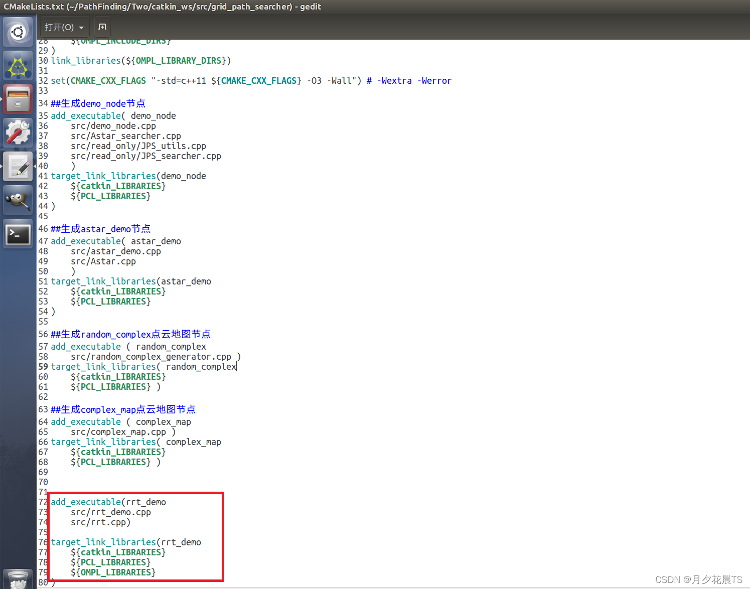
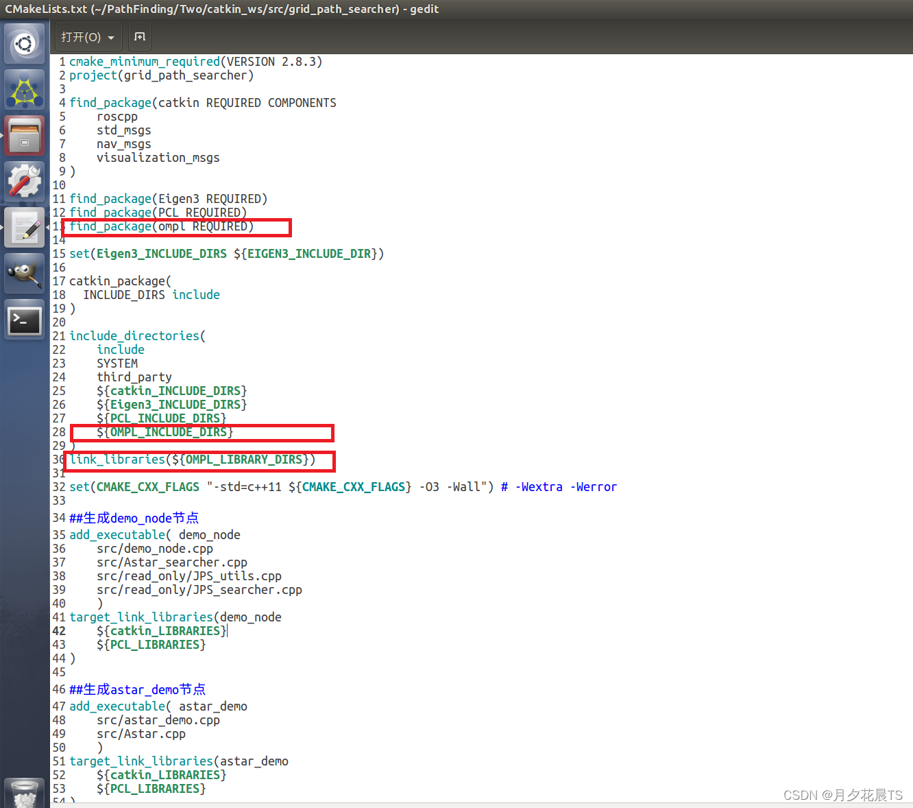
3.1.5 CMakeLists.txt修改
主要增加OMPL包的依赖,如下图所示。
3.1.6 编译
问题1:
在编译的过程中若出现
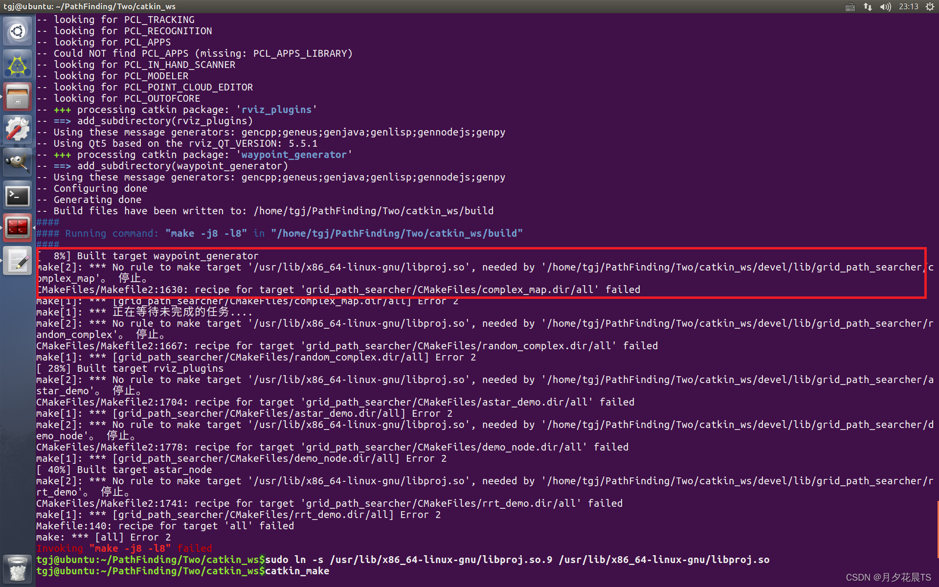
通过软链接来解决,指令如下
sudo ln -s /usr/lib/x86_64-linux-gnu/libproj.so.9 /usr/lib/x86_64-linux-gnu/libproj.so
问题2:
编译过程中若出现缺少ompl-Config的问题,那是缺少ros的ompl包,因此通过
sudo apt-get install ros-kinetic-ompl
3.2 代码展示
运行
roslaunch grid_path_searcher rrt_demo.launch
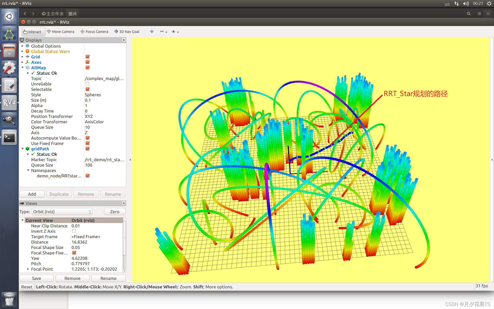
效果展示
代码参考:
三维点云代码链接:https://github.com/KailinTong/Motion-Planning-for-Mobile-Robots
OMPL参考链接:https://blog.csdn.net/mapleleaf98/article/details/124540749


 723
723


 被折叠的 条评论
为什么被折叠?
被折叠的 条评论
为什么被折叠?
 到【灌水乐园】发言


