


A method is used in image registration.
The detected features in the reference and sensed images can be matched by means of the image intensity values in their close neighborhoods, the feature spatial distribution, or the feature symbolic description, looking for the feature correspondence.
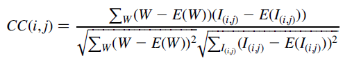
Area-based methods:
correlation-like methods
using cross-correlation
H. Hanaizumi, S. Fujimura, An automated method for registration of satellite remote sensing images, Proceedings of the International Geoscience and Remote Sensing Symposium IGARSS’93, Tokyo, Japan, 1993, pp. 1348–1350.
1\estimation of ratio of spatial resolution and relative and shift between images.
2\automatic generation of GCP(ground control point) pairs
3\divide picture into triangles
4\piece-wise rectification between the triangles(affine-transformation)
AN AUTOMATED METHOD FOR REGISTRATION OF SATELLITE REMOTE SENSING IMAGES
Feature-based methods:
To be continued…


 549
549


 被折叠的 条评论
为什么被折叠?
被折叠的 条评论
为什么被折叠?
 到【灌水乐园】发言


