


这个模块主要的功能就是接收featureExtraction 传来的coud_info 数据,把点云特征点根据初始化的里程计信息转换到map坐标系下,然后对当前帧的点云特征点信息进行scan-map 匹配优化,这里用到loam里面的点到线,点到面的距离作为残差项,用高斯牛顿法优化里程计信息,然后按照匀速运动模型计算一个超前一个lidar周期的odom_imcremental里程计,传送到IMU 预积分模块使用。
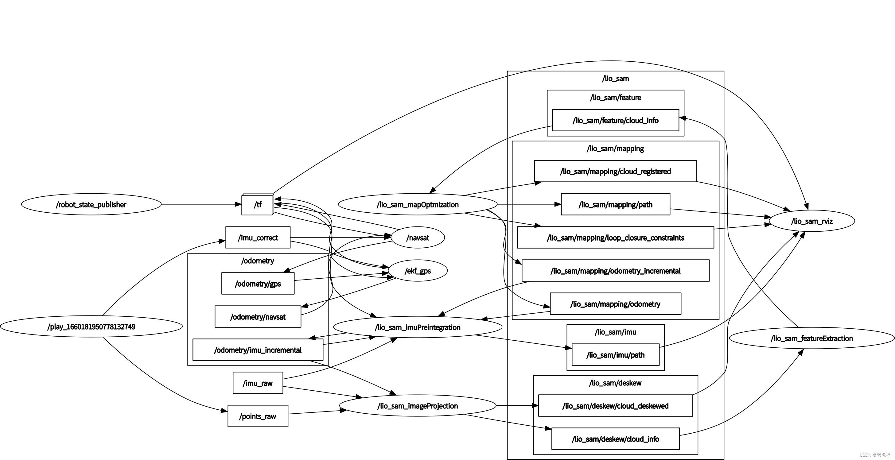
图2.ros topic 发布与订阅关系图关系图(还是叫图2,因为是同一个图)

图1.代码架构图(数据流图)
成员变量列表
| 变量名 | 类型 | 注释 | 备注 |
| gtSAMgraph | NonlinearFactorGraph | 因子图 | - |
| initialEstimate | Values | 因子途中待优化的变量 | - |
| optimizedEstimate | Values | 因子图中的变量,用于保存优化后的结果 | - |
| *isam | ISAM2 | 因子图的优化器 | - |
| isamCurrentEstimate | Values | 因子图中的变量 | - |
| poseCovariance | Eigen::MatrixXd | 因子图中的协方差模型 | - |
| pubLaserCloudSurround | ros::Publisher | 发布全局地图? "lio_sam/mapping/map_global" 这里也没有发布全局地图,有设定阈值,默认时1000米范围内的特征点地图 | - |
| pubLaserOdometryGlobal | ros::Publisher | 发布地图优化后的 里程计信息 "lio_sam/mapping/odometry" // 在imuPreintegration文件的中的TransformFusion类订阅,融合imu 里程计后发布出发布 "odometry/imu_incremental" // 供imageProjection 1.lidar 运动畸变矫正 2.提取lidar的位姿信息 集成到cloud-info中 回到当前这个类 作lidar 位姿初始化 | - |
| pubLaserOdometryIncremental | ros::Publisher | 发布 "lio_sam/mapping/odometry_incremental" 里程计信息,与上面的区别是,比lio_sam/mapping/map_global 超前一个Lidar优化周期的里程计信息 , // 在 imuPreintegration 类中订阅,用于因子途中位姿优化的位姿初始化 | - |
| pubKeyPoses | ros::Publisher | 发布 "lio_sam/mapping/trajectory",sensor_msgs::PointCloud2类型 系统中没有人订阅 | - |
| pubPath | ros::Publisher | 发布 "lio_sam/mapping/path" | - |
| pubHistoryKeyFrames | ros::Publisher | 发布"lio_sam/mapping/icp_loop_closure_history_cloud" | - |
| pubHistoryKeyFrames | ros::Publisher | 发布"lio_sam/mapping/icp_loop_closure_history_cloud" | - |
| pubIcpKeyFrames | ros::Publisher | //"lio_sam/mapping/icp_loop_closure_corrected_cloud" | - |
| pubRecentKeyFrames | ros::Publisher | //"lio_sam/mapping/map_local" sensor_msgs::PointCloud2 ? | - |
| pubRecentKeyFrames | ros::Publisher | //"lio_sam/mapping/cloud_registered sensor_msgs::PointCloud2 ? | - |
| pubCloudRegisteredRaw | ros::Publisher | // "lio_sam/mapping/cloud_registered_raw" | - |
| pubLoopConstraintEdge | ros::Publisher | "/lio_sam/mapping/loop_closure_constraints" visualization_msgs::MarkerArray ? | - |
| pubSLAMInfo | ros::Publisher | //"lio_sam/mapping/slam_info" lio_sam::cloud_info | - |
| subCloud | ros::Subscriber | //"lio_sam/feature/cloud_info" lio_sam::cloud_info 订阅来自featureExtraction的cloud_info | - |
| subGPS | ros::Subscriber | //"odometry/gpsz" # GPS odometry topic from navsat, see module_navsat.launch file | - |
| subLoop | ros::Subscriber | //"lio_loop/loop_closure_detection" 类型std_msgs::Float64MultiArray | - |
| srvSaveMap | ros::ServiceServer | - | |
| gpsQueue | std::deque | // GPS的消息队列 | - |
| cloudInfo | lio_sam::cloud_info | // featureExtraction发来的点云特征消息,这里不再是队列, //来一个处理一个,处理的延迟应该低于lidar数据发布延迟,不然会卡顿丢帧 ?优化过程是执行周期 mappingProcessInterval,lidar 数据的频率是10Hz | - |
| cornerCloudKeyFrames | vector::Ptr> | 真正地图存储的数据 // 数组存放每个关键帧的边角点 | - |
| surfCloudKeyFrames | vector::Ptr> | 真正地图存储的数据 // 数组存放每个关键帧的平面点 | - |
| cloudKeyPoses3D | vector::Ptr> | 真正地图存储的数据 // //存放关键帧的位置 (不包含旋转信息) | - |
| cloudKeyPoses6D | pcl::PointCloud::Ptr | 真正地图存储的数据 // 存放关键帧的位置 (包含旋转信息) ,位置信息跟cloudKeyPoses3D 一致 | - |
| copy_cloudKeyPoses3D | pcl::PointCloud::Ptr | 临时变量 | - |
| copy_cloudKeyPoses6D | pcl::PointCloud::Ptr | 临时变量 | - |
| laserCloudCornerLast | pcl::PointCloud::Ptr | corner feature set from odoOptimization 从cloud_info 中提取的当前帧的边角点点云数据 | - |
| laserCloudSurfLast | pcl::PointCloud::Ptr | surf feature set from odoOptimization 从cloud_info 中提取的当前帧的平面点点云数据 | - |
| laserCloudCornerLastDS | pcl::PointCloud::Ptr | downsampled corner feature set from odoOptimization | - |
| laserCloudSurfLastDS | pcl::PointCloud::Ptr | downsampled surf feature set from odoOptimization | - |
| laserCloudOri | pcl::PointCloud::Ptr | scan-map优化过程中 存放lidar 坐标系下的特征点数据 | - |
| coeffSel | pcl::PointCloud::Ptr | // 优化过程中 存放距离函数对lidar 坐标系下的特征点映射到map坐标系后的雅可比 | - |
| laserCloudOriCornerVec | std::vector | 在使用openmp 加速计算时 用于保存角点特征原点的变量// corner point holder for parallel computation | - |
| coeffSelCornerVec | std::vector | 在使用openmp 加速计算时 用于保存角点特征原点的雅可比变量// corner point holder for parallel computation | - |
| laserCloudOriCornerFlag | std::vector | 在使用openmp 加速计算时 用于保存角点特征原点的占用标志位// corner point holder for parallel computation | - |
| laserCloudOriSurfVec | std::vector | 在使用openmp 加速计算时 用于保存平面特征原点的变量// surf point holder for parallel computation | - |
| coeffSelSurfVec | std::vector | 在使用openmp 加速计算时 用于保存平面特征原点的雅可比变量// surf point holder for parallel computation | - |
| laserCloudOriSurfFlag | std::vector | 在使用openmp 加速计算时 用于保存平面点特征原点的占用标志位// surf point holder for parallel computation | - |
| laserCloudMapContainer | map, pcl::PointCloud>> | 保存地图 这个地图容器 1000帧关键帧之后,会清空,所以保存的不是全局地图 // 作用 仅仅时缓存一些关键帧数据,能够快速的构建局部地图 | - |
| laserCloudCornerFromMap | pcl::PointCloud::Ptr | 局部地图的所有角点特征融合 | - |
| laserCloudSurfFromMap | pcl::PointCloud::Ptr | // 局部地图的所有面点特征 | - |
| laserCloudCornerFromMapDS | pcl::PointCloud::Ptr | // 局部地图的所有角点特征的下采样点云,在scan-map 优化值中真正用到的数据 | - |
| laserCloudSurfFromMapDS | pcl::PointCloud::Ptr | // 局部地图的所有面点特征的下采样点云,在scan-map 优化值中真正用到的数据 | - |
| kdtreeCornerFromMap | pcl::KdTreeFLANN::Ptr | // 局部地图的所有角点特征的下采样点云对用的Kdtree | - |
| kdtreeSurfFromMap | pcl::KdTreeFLANN::Ptr | // 局部地图的所有面点特征的下采样点云对用的Kdtree | - |
| kdtreeSurroundingKeyPoses | pcl::KdTreeFLANN::Ptr | // 关键帧位置数组对应的一个KDtree | - |
| kdtreeHistoryKeyPoses | pcl::KdTreeFLANN::Ptr | // 关键帧位置数组对应的一个KDtree,这个 对应可视化部分用到的 | - |
| downSizeFilterCorner | pcl::VoxelGrid | // 下采样器 | - |
| downSizeFilterSurf | pcl::VoxelGrid | // 下采样器 | - |
| downSizeFilterICP | pcl::VoxelGrid | // 下采样器 | - |
| downSizeFilterSurroundingKeyPoses | pcl::VoxelGrid | for surrounding key poses of scan-to-map optimization// 下采样器 | - |
| timeLaserInfoStamp | ros::Time | 这个时间戳是cloud_info 的时间戳,经过了imageProjection /featureExtraction 已经不是很新鲜的是时间戳了 | - |
| timeLaserInfoCur | double | 这个时间戳是cloud_info 的时间戳,经过了imageProjection /featureExtraction 已经不是很新鲜的是时间戳了 | - |
| transformTobeMapped[6] | float | 待优化的位姿变量,整个文件围绕着这个变量进行 | - |
| mtx | std::mutex | 互斥量 | - |
| mtxLoopInfo | std::mutex | 回环检测的互斥量 | - |
| isDegenerate | bool | 标志要不要计算优化变量的协方差,雅可比矩阵的特征值均小于100时 不需要计算协方差 | - |
| matP | cv::Mat | 优化变量的协方差矩阵 | - |
| laserCloudCornerFromMapDSNum | int | - | |
| laserCloudSurfFromMapDSNum | int | - | |
| laserCloudCornerLastDSNum | int | - | |
| laserCloudSurfLastDSNum | int | - | |
| aLoopIsClosed | bool | 标志是否有回环检测模块 | - |
| loopIndexContainer | map | - | |
| loopPoseQueue | vector | - | |
| loopNoiseQueue | vector | - | |
| loopInfoVec | deque | - | |
| globalPath | nav_msgs::Path | - | |
| transPointAssociateToMap | Eigen::Affine3f | 把lidar 点云映射到的map坐标系的转换矩阵,对应着transformTobeMapped 的值 | - |
| incrementalOdometryAffineFront | Eigen::Affine3f | 本文件整个优化前对应着transformTobeMapped 的值 | - |
| incrementalOdometryAffineBack | Eigen::Affine3f | 本文件整个优化后对应着transformTobeMapped 的值,这两转换矩阵作差,就是匀速运动学模型的速度,用于计算lidar 周期的朝一个周期的优化 里程计信息,在发布 odom_imcremental 里程计时要用到 | - |
代码注解
这里的代码的主要逻辑从 cloud_info 的回调函数为入口:
/**
 * @brief  CloudInfo 的回调函数
 *
 * @param msgIn
 */
    void laserCloudInfoHandler(const lio_sam::cloud_infoConstPtr& msgIn)
    {
        // extract time stamp
        timeLaserInfoStamp = msgIn->header.stamp;
        timeLaserInfoCur = msgIn->header.stamp.toSec();

        // extract info and feature cloud
        cloudInfo = *msgIn;
        pcl::fromROSMsg(msgIn->cloud_corner,  *laserCloudCornerLast);  // 当前帧的角点
        pcl::fromROSMsg(msgIn->cloud_surface, *laserCloudSurfLast);    // 当前帧的平面点

        std::lock_guard<std::mutex> lock(mtx);

        static double timeLastProcessing = -1;
        // seconds, regulate mapping frequencymapOptimization 的执行时间间隔,地图优化的执行周期,比lidar 频率慢
        if (timeLaserInfoCur - timeLastProcessing >= mappingProcessInterval)
        {
            timeLastProcessing = timeLaserInfoCur;
            /**
             * @brief 把上一次有优化的结果 transformTobeMapped存放到incrementalOdometryAffineFront 之后
             * 用imu预积分的里程计信息或者IMU 信息(只做旋转变换)初始化当前lidar的位姿transformTobeMapped
             *
             */
            updateInitialGuess();
            /**
             * @brief Construct a new extract Surrounding Key Frames object
             * 在cloudKeyPoses3D 这个数组中搜索 以loudKeyPoses3D.back()为中心 的周边50米的距离的关键帧数据 构建局部地图
             * 并构造角点局部地图和平面点局部地图 ,
             * 存放在laserCloudCornerFromMapDS
             * 和laserCloudSurfFromMapDS
             */
            extractSurroundingKeyFrames();
            /**
             * @brief 对当前帧的点云角点 和平面点 进行下采样
             *
             */
            downsampleCurrentScan();
            //用局部构建的地图去优化当前帧的位姿
            scan2MapOptimization();
            // 添加因子图和保存优化后的关键帧数据
            saveKeyFramesAndFactor();
            // 如果发生回环 ,需要把回环对应的历史位姿更新以下
            correctPoses();

            publishOdometry();

            publishFrames();
        }
    }
做值优化问题,都需要有一个初始值,在loam 和lego_loam 中都是通过scan-scan 的方式得出scan-map的初始值,有了imu 数据之后,可以通过imu 预积分数据作scan-map的初始值。
/**
 * @brief 把上一次有优化的结果 transformTobeMapped存放到incrementalOdometryAffineFront 之后
 * 用imu预积分的里程计信息或者IMU 信息(只做旋转变换)初始化当前lidar的位姿transformTobeMapped
 *
 */
    void updateInitialGuess()
    {
        // save current transformation before any processing
        incrementalOdometryAffineFront = trans2Affine3f(transformTobeMapped); // 把上一次优化的结果 保存在incrementalOdometryAffineFront

        static Eigen::Affine3f lastImuTransformation; // 保存IMU 里程计到当前帧时刻的里程计信息
        // initialization
        if (cloudKeyPoses3D->points.empty()) // 地图里面没有数据,表示当前为初始位置,
        {
            // 初始时刻 机器人的朝向取 IMU 的朝向
            transformTobeMapped[0] = cloudInfo.imuRollInit;
            transformTobeMapped[1] = cloudInfo.imuPitchInit;
            transformTobeMapped[2] = cloudInfo.imuYawInit;

            // 超参数:在yaml 文件中设置 if using GPS data, set to "true" ,useImuHeadingInitialization 如果不用 imu朝向 ,把yaw 置为0
            if (!useImuHeadingInitialization)
                transformTobeMapped[2] = 0;

            lastImuTransformation = pcl::getTransformation(0, 0, 0, cloudInfo.imuRollInit, cloudInfo.imuPitchInit, cloudInfo.imuYawInit); // save imu before return;
            return;
        }

        // use imu pre-integration estimation for pose guess
        static bool lastImuPreTransAvailable = false;
        //这个变量保存IMU 的预积分的里程计信息,关联两次优化
        static Eigen::Affine3f lastImuPreTransformation;
        if (cloudInfo.odomAvailable == true)
        {
            // 这里看到一对 XXXFront 和 XXXBack ,之后肯定是要作差的,表示之前的时刻到当前时刻的位姿差
            Eigen::Affine3f transBack = pcl::getTransformation(cloudInfo.initialGuessX,    cloudInfo.initialGuessY,     cloudInfo.initialGuessZ,
                                                               cloudInfo.initialGuessRoll, cloudInfo.initialGuessPitch, cloudInfo.initialGuessYaw);
            if (lastImuPreTransAvailable == false)
            {   // 第一次设置时,
                lastImuPreTransformation = transBack;
                lastImuPreTransAvailable = true;
            } else {
                // 两次优化之间的发生的位姿差 delta_T = T_i^T * T_j
                Eigen::Affine3f transIncre = lastImuPreTransformation.inverse() * transBack;
                Eigen::Affine3f transTobe = trans2Affine3f(transformTobeMapped);
                // T_j'' = T_i' * delta_T 其中 T_j'' 为待优化的变量的初始值
                Eigen::Affine3f transFinal = transTobe * transIncre;
                pcl::getTranslationAndEulerAngles(transFinal, transformTobeMapped[3], transformTobeMapped[4], transformTobeMapped[5],
                                                              transformTobeMapped[0], transformTobeMapped[1], transformTobeMapped[2]);

                lastImuPreTransformation = transBack; // 一直保存IMU 预积分里程计的信息,传递下去

                lastImuTransformation = pcl::getTransformation(0, 0, 0, cloudInfo.imuRollInit, cloudInfo.imuPitchInit, cloudInfo.imuYawInit); // save imu before return;
                return;
            }
        }

        // use imu incremental estimation for pose guess (only rotation)
        if (cloudInfo.imuAvailable == true)
        {
            Eigen::Affine3f transBack = pcl::getTransformation(0, 0, 0, cloudInfo.imuRollInit, cloudInfo.imuPitchInit, cloudInfo.imuYawInit);
            Eigen::Affine3f transIncre = lastImuTransformation.inverse() * transBack;

            Eigen::Affine3f transTobe = trans2Affine3f(transformTobeMapped);
            Eigen::Affine3f transFinal = transTobe * transIncre;
            pcl::getTranslationAndEulerAngles(transFinal, transformTobeMapped[3], transformTobeMapped[4], transformTobeMapped[5],
                                                          transformTobeMapped[0], transformTobeMapped[1], transformTobeMapped[2]);

            lastImuTransformation = pcl::getTransformation(0, 0, 0, cloudInfo.imuRollInit, cloudInfo.imuPitchInit, cloudInfo.imuYawInit); // save imu before return;
            return;
        }
    }
在scan-map 优化执行之前,首先需要有一个map,淡然不能是全局map,内存撑爆,且运算时间剧增,也没必要用全局map ,这里用的是距离最新历史关键帧50米范围内的关键帧数据作为一个局部地图取匹配优化当前帧的位姿。
/**
 * 这个函数就是调用了extractNearby函数
 * */
    void extractSurroundingKeyFrames()
    {
        if (cloudKeyPoses3D->points.empty() == true)
            return;
        // ?
        // if (loopClosureEnableFlag == true)
        // {
        //     extractForLoopClosure();
        // } else {
        //     extractNearby();
        // }

        extractNearby();
    }
上面这个函数就是调用了extractNearby函数,在cloudKeyPoses3D 这个数组中搜索 以loudKeyPoses3D.back()为中心 的周边50米的距离的关键帧数据 构建局部地图。
/**
 * @brief 在cloudKeyPoses3D 这个数组中搜索 以loudKeyPoses3D.back()为中心 的周边50米的距离的关键帧数据 构建局部地图
 *
 */
    void extractNearby()
    {   // 搜索出来距离50米的关键帧位姿(位置)存放在这个点云容器中
        pcl::PointCloud<PointType>::Ptr surroundingKeyPoses(new pcl::PointCloud<PointType>());
        pcl::PointCloud<PointType>::Ptr surroundingKeyPosesDS(new pcl::PointCloud<PointType>());
        // 这两个变量是 KDtree 搜索用到的两个临时变量
        std::vector<int> pointSearchInd;
        std::vector<float> pointSearchSqDis;

        // extract all the nearby key poses and downsample them
        kdtreeSurroundingKeyPoses->setInputCloud(cloudKeyPoses3D); // create kd-tree
        // 以cloudKeyPoses3D->back() 为中心 以surroundingKeyframeSearchRadius(默认50米)为半径 搜索最近的点
        kdtreeSurroundingKeyPoses->radiusSearch(cloudKeyPoses3D->back(), (double)surroundingKeyframeSearchRadius, pointSearchInd, pointSearchSqDis);
        for (int i = 0; i < (int)pointSearchInd.size(); ++i)
        {
            int id = pointSearchInd[i];
            surroundingKeyPoses->push_back(cloudKeyPoses3D->points[id]);
        }

        downSizeFilterSurroundingKeyPoses.setInputCloud(surroundingKeyPoses);
        // 下采样之后,点云里的点不完全时原始的点,有些是融合过 ,所以时间戳信息 需要重新获取一下
        downSizeFilterSurroundingKeyPoses.filter(*surroundingKeyPosesDS);
        for(auto& pt : surroundingKeyPosesDS->points)
        {   // 再找一遍,把原始点云的最近的点的intensity赋值给新的位置点 ,intensity 在这个是在这个地图中的索引 也是laserCloudMapContainer容器的索引
            kdtreeSurroundingKeyPoses->nearestKSearch(pt, 1, pointSearchInd, pointSearchSqDis);
            pt.intensity = cloudKeyPoses3D->points[pointSearchInd[0]].intensity;
        }

        // also extract some latest key frames in case the robot rotates in one position
        int numPoses = cloudKeyPoses3D->size();
        for (int i = numPoses-1; i >= 0; --i)
        {
            // 过滤完之后 ,surroundingKeyPosesDS在添加一些  时间比较接近的位置点
            if (timeLaserInfoCur - cloudKeyPoses6D->points[i].time < 10.0)
                surroundingKeyPosesDS->push_back(cloudKeyPoses3D->points[i]);
            else
                break;
        }

        extractCloud(surroundingKeyPosesDS);
    }
然后再调用extractCloud 函数,搜索出来距离50米的关键帧位姿(位置)的角点点云和平面点点云,存放在laserCloudCornerFromMapDS和laserCloudSurfFromMapDS中
/**
 * @brief  搜索出来距离50米的关键帧位姿(位置)的角点点云和平面点点云
 * 存放在laserCloudCornerFromMapDS
 * 和laserCloudSurfFromMapDS
 *
 * @param cloudToExtract
 */
    void extractCloud(pcl::PointCloud<PointType>::Ptr cloudToExtract)
    {
        // fuse the map
        laserCloudCornerFromMap->clear();
        laserCloudSurfFromMap->clear();
        for (int i = 0; i < (int)cloudToExtract->size(); ++i)
        {   // 添加关键帧的搜索半径 , 局部地图的距离最新帧中心阈值
            if (pointDistance(cloudToExtract->points[i], cloudKeyPoses3D->back()) > surroundingKeyframeSearchRadius)
                continue;

            int thisKeyInd = (int)cloudToExtract->points[i].intensity;
            if (laserCloudMapContainer.find(thisKeyInd) != laserCloudMapContainer.end())
            {   // 局部地图 角点地图 和平面点地图
                // transformed cloud available
                *laserCloudCornerFromMap += laserCloudMapContainer[thisKeyInd].first;
                *laserCloudSurfFromMap   += laserCloudMapContainer[thisKeyInd].second;
            } else {
                // transformed cloud not available
                // 把点云 从lidar 坐标系转到world 坐标系
                pcl::PointCloud<PointType> laserCloudCornerTemp = *transformPointCloud(cornerCloudKeyFrames[thisKeyInd],  &cloudKeyPoses6D->points[thisKeyInd]);
                pcl::PointCloud<PointType> laserCloudSurfTemp = *transformPointCloud(surfCloudKeyFrames[thisKeyInd],    &cloudKeyPoses6D->points[thisKeyInd]);
                *laserCloudCornerFromMap += laserCloudCornerTemp;
                *laserCloudSurfFromMap   += laserCloudSurfTemp;
                // 添加到 地图容器中
                laserCloudMapContainer[thisKeyInd] = make_pair(laserCloudCornerTemp, laserCloudSurfTemp);
            }

        }

        // Downsample the surrounding corner key frames (or map)
        downSizeFilterCorner.setInputCloud(laserCloudCornerFromMap);
        downSizeFilterCorner.filter(*laserCloudCornerFromMapDS);
        laserCloudCornerFromMapDSNum = laserCloudCornerFromMapDS->size();
        // Downsample the surrounding surf key frames (or map)
        downSizeFilterSurf.setInputCloud(laserCloudSurfFromMap);
        downSizeFilterSurf.filter(*laserCloudSurfFromMapDS);
        laserCloudSurfFromMapDSNum = laserCloudSurfFromMapDS->size();

        // clear map cache if too large
        // 地图数据清空 缓存1000帧
        if (laserCloudMapContainer.size() > 1000)
            laserCloudMapContainer.clear();
    }
有了初始值,有了局部地图,就可以执行scan-map 匹配优化了。
分三部:1.根据初始值变换角点到map 坐标系下,计算点到线的残差项,及其对变换后的点的雅可比,保存起来。
2. 根据初始值变换平面点到map 坐标系下,计算点到面的残差项,及其对变换后的点的雅可比,保存起来。
3. 计算变换后的点对变换矩阵中 R 和t 的雅可比,然后用高斯牛顿法优化待优化变量。
这里详细讲解一下计算过程,可能这部分内容源自loam 或者是其他文献,所以著者也没有详细给出讲解:
(1)先准备以下数据:由于有了初始值 transformTobeMapped ,我们可以得到初始的旋转角,
,
,
,
,
。
所与可以得到旋转矩阵
(2) 论文中给出 点到线的距离公式,这里直接沿用,至于怎么来loam中讲得很明白,这里旨在读懂代码,明确代码里的变量怎么来。
点到线的距离公式:,为了简化公式编写且与代码中的变量标号相对应,点到线的距离公式简化成
,首先要确定这几个点是怎么来的,其中
为从lidar 坐标系变换到map 坐标系下的点,即
,
和
主要来自与主成分分析法(PCA),在map 中找出距离
最近的5个点,作主成分分析,如果这5个的点协方差矩阵的其中一个特征值远大于其他两个,则这5个点成线性分布,最大特征值对应的特征向量即为该直线的方向,在这5个点的中心沿着直线的正反方向各取一个点,即为
和
。
(3)这里先给出 对
和
的雅可比,因为无论是平面点 或者是角点特征,都经过了这个变换,雅可比是一致,代码中也是这么分开来实现的。
对的雅可比 为
。
(4)在函数cornerOptimization中求得点到线距离的残差项 存放在coeff.intensity 中,雅可比项就是存放在coeff的x,y,z 中。现在来推到点到线距离残差项对
的雅可比。
1)首先要知道 各位可以 用(x,y,z)的模来推导一下.
2)
然后一项一项对应到代码里面去就好了。这样比看代码好理解一些。点到平面的距离就不写了(懒)。
void cornerOptimization()
    {   // 把初始化过后的待优化变量transformTobeMapped 转换成一个转换矩阵transPointAssociateToMap,
        // 用于对当前帧点云的坐标系转化到map 坐标系
        updatePointAssociateToMap();

        #pragma omp parallel for num_threads(numberOfCores)
        for (int i = 0; i < laserCloudCornerLastDSNum; i++)
        {
            // pointOri lidar 坐标系下的特征点
            // pointSel 是pointOri 转化到Map 坐标系下的点
            // coeff 距离函数对pointSel 的雅可比
            PointType pointOri, pointSel, coeff;
            // kdtree 搜索近邻点所需要的两个临时变量
            std::vector<int> pointSearchInd;
            std::vector<float> pointSearchSqDis;

            pointOri = laserCloudCornerLastDS->points[i]; //当前帧的特征点
            // 把点云点从lidar 坐标系映射到Map 坐标系
            pointAssociateToMap(&pointOri, &pointSel);
            // 以pointSel 为中心在局部地图的KdTree中找最近的5个点
            kdtreeCornerFromMap->nearestKSearch(pointSel, 5, pointSearchInd, pointSearchSqDis);

            cv::Mat matA1(3, 3, CV_32F, cv::Scalar::all(0)); // matA1 为这5个点的协方差矩阵
            cv::Mat matD1(1, 3, CV_32F, cv::Scalar::all(0)); // matD1 为协方差矩阵的特征值
            cv::Mat matV1(3, 3, CV_32F, cv::Scalar::all(0)); // matV1 为协方差矩阵的特征向量
             //从KdTree中找最近的5个点中最远距离的那个的距离小于1M,认为中的找到的这5个点有效
            if (pointSearchSqDis[4] < 1.0) {
                // C =[cx,cy,cz]^T 为这5个点的中心
                float cx = 0, cy = 0, cz = 0;
                for (int j = 0; j < 5; j++) {
                    cx += laserCloudCornerFromMapDS->points[pointSearchInd[j]].x;
                    cy += laserCloudCornerFromMapDS->points[pointSearchInd[j]].y;
                    cz += laserCloudCornerFromMapDS->points[pointSearchInd[j]].z;
                }
                cx /= 5; cy /= 5;  cz /= 5;

                float a11 = 0, a12 = 0, a13 = 0, a22 = 0, a23 = 0, a33 = 0;
                for (int j = 0; j < 5; j++) {
                    float ax = laserCloudCornerFromMapDS->points[pointSearchInd[j]].x - cx;
                    float ay = laserCloudCornerFromMapDS->points[pointSearchInd[j]].y - cy;
                    float az = laserCloudCornerFromMapDS->points[pointSearchInd[j]].z - cz;

                    a11 += ax * ax; a12 += ax * ay; a13 += ax * az;
                    a22 += ay * ay; a23 += ay * az;
                    a33 += az * az;
                }
                a11 /= 5; a12 /= 5; a13 /= 5; a22 /= 5; a23 /= 5; a33 /= 5;

                matA1.at<float>(0, 0) = a11; matA1.at<float>(0, 1) = a12; matA1.at<float>(0, 2) = a13;
                matA1.at<float>(1, 0) = a12; matA1.at<float>(1, 1) = a22; matA1.at<float>(1, 2) = a23;
                matA1.at<float>(2, 0) = a13; matA1.at<float>(2, 1) = a23; matA1.at<float>(2, 2) = a33;
                // 求取matA1 的特征值和特征向量
                cv::eigen(matA1, matD1, matV1);
                // matD1 是按从达到小的顺序分布的,如果特征值的第1个值比第二值足够大  则认为 这5个点是成线型分布的
                // 并且 其对应的特征向量则为直线的方向
                if (matD1.at<float>(0, 0) > 3 * matD1.at<float>(0, 1)) {
                    // 构造3个点,这样就可计算一个点到其他两个点所在的直线的距离
                    // 1.当前帧lidar 在map坐标系下的映射点
                    float x0 = pointSel.x;
                    float y0 = pointSel.y;
                    float z0 = pointSel.z;
                    // 2. 在5点的均值点处沿着 直线方向 距离0.1 取一个点
                    float x1 = cx + 0.1 * matV1.at<float>(0, 0);
                    float y1 = cy + 0.1 * matV1.at<float>(0, 1);
                    float z1 = cz + 0.1 * matV1.at<float>(0, 2);
                    // 3. 在5点的均值点处沿着 直线反方向 距离0.1 取一个点
                    float x2 = cx - 0.1 * matV1.at<float>(0, 0);
                    float y2 = cy - 0.1 * matV1.at<float>(0, 1);
                    float z2 = cz - 0.1 * matV1.at<float>(0, 2);

                    float a012 = sqrt(((x0 - x1)*(y0 - y2) - (x0 - x2)*(y0 - y1)) * ((x0 - x1)*(y0 - y2) - (x0 - x2)*(y0 - y1))
                                    + ((x0 - x1)*(z0 - z2) - (x0 - x2)*(z0 - z1)) * ((x0 - x1)*(z0 - z2) - (x0 - x2)*(z0 - z1))
                                    + ((y0 - y1)*(z0 - z2) - (y0 - y2)*(z0 - z1)) * ((y0 - y1)*(z0 - z2) - (y0 - y2)*(z0 - z1)));

                    float l12 = sqrt((x1 - x2)*(x1 - x2) + (y1 - y2)*(y1 - y2) + (z1 - z2)*(z1 - z2));

                    float la = ((y1 - y2)*((x0 - x1)*(y0 - y2) - (x0 - x2)*(y0 - y1))
                              + (z1 - z2)*((x0 - x1)*(z0 - z2) - (x0 - x2)*(z0 - z1))) / a012 / l12;

                    float lb = -((x1 - x2)*((x0 - x1)*(y0 - y2) - (x0 - x2)*(y0 - y1))
                               - (z1 - z2)*((y0 - y1)*(z0 - z2) - (y0 - y2)*(z0 - z1))) / a012 / l12;

                    float lc = -((x1 - x2)*((x0 - x1)*(z0 - z2) - (x0 - x2)*(z0 - z1))
                               + (y1 - y2)*((y0 - y1)*(z0 - z2) - (y0 - y2)*(z0 - z1))) / a012 / l12;

                    float ld2 = a012 / l12;
                    // 残差项乘以一个系数,类似于核函数
                    float s = 1 - 0.9 * fabs(ld2);

                    coeff.x = s * la;
                    coeff.y = s * lb;
                    coeff.z = s * lc;
                    coeff.intensity = s * ld2;

                    if (s > 0.1) {
                        laserCloudOriCornerVec[i] = pointOri;
                        coeffSelCornerVec[i] = coeff;
                        laserCloudOriCornerFlag[i] = true;
                    }
                }
            }
        }
    }

    void surfOptimization()
    {
        updatePointAssociateToMap();

        #pragma omp parallel for num_threads(numberOfCores)
        for (int i = 0; i < laserCloudSurfLastDSNum; i++)
        {
            PointType pointOri, pointSel, coeff;
            std::vector<int> pointSearchInd;
            std::vector<float> pointSearchSqDis;

            pointOri = laserCloudSurfLastDS->points[i];
            pointAssociateToMap(&pointOri, &pointSel);
            kdtreeSurfFromMap->nearestKSearch(pointSel, 5, pointSearchInd, pointSearchSqDis);

            Eigen::Matrix<float, 5, 3> matA0;
            Eigen::Matrix<float, 5, 1> matB0;
            Eigen::Vector3f matX0;

            matA0.setZero();
            matB0.fill(-1);
            matX0.setZero();

            if (pointSearchSqDis[4] < 1.0) {
                for (int j = 0; j < 5; j++) {
                    matA0(j, 0) = laserCloudSurfFromMapDS->points[pointSearchInd[j]].x;
                    matA0(j, 1) = laserCloudSurfFromMapDS->points[pointSearchInd[j]].y;
                    matA0(j, 2) = laserCloudSurfFromMapDS->points[pointSearchInd[j]].z;
                }

                matX0 = matA0.colPivHouseholderQr().solve(matB0);

                float pa = matX0(0, 0);
                float pb = matX0(1, 0);
                float pc = matX0(2, 0);
                float pd = 1;

                float ps = sqrt(pa * pa + pb * pb + pc * pc);
                pa /= ps; pb /= ps; pc /= ps; pd /= ps;

                bool planeValid = true;
                for (int j = 0; j < 5; j++) {
                    if (fabs(pa * laserCloudSurfFromMapDS->points[pointSearchInd[j]].x +
                             pb * laserCloudSurfFromMapDS->points[pointSearchInd[j]].y +
                             pc * laserCloudSurfFromMapDS->points[pointSearchInd[j]].z + pd) > 0.2) {
                        planeValid = false;
                        break;
                    }
                }

                if (planeValid) {
                    float pd2 = pa * pointSel.x + pb * pointSel.y + pc * pointSel.z + pd;

                    float s = 1 - 0.9 * fabs(pd2) / sqrt(sqrt(pointOri.x * pointOri.x
                            + pointOri.y * pointOri.y + pointOri.z * pointOri.z));

                    coeff.x = s * pa;
                    coeff.y = s * pb;
                    coeff.z = s * pc;
                    coeff.intensity = s * pd2;

                    if (s > 0.1) {
                        laserCloudOriSurfVec[i] = pointOri;
                        coeffSelSurfVec[i] = coeff;
                        laserCloudOriSurfFlag[i] = true;
                    }
                }
            }
        }
    }

    void combineOptimizationCoeffs()
    {
        // combine corner coeffs
        for (int i = 0; i < laserCloudCornerLastDSNum; ++i){
            if (laserCloudOriCornerFlag[i] == true){
                laserCloudOri->push_back(laserCloudOriCornerVec[i]);
                coeffSel->push_back(coeffSelCornerVec[i]);
            }
        }
        // combine surf coeffs
        for (int i = 0; i < laserCloudSurfLastDSNum; ++i){
            if (laserCloudOriSurfFlag[i] == true){
                laserCloudOri->push_back(laserCloudOriSurfVec[i]);
                coeffSel->push_back(coeffSelSurfVec[i]);
            }
        }
        // reset flag for next iteration
        std::fill(laserCloudOriCornerFlag.begin(), laserCloudOriCornerFlag.end(), false);
        std::fill(laserCloudOriSurfFlag.begin(), laserCloudOriSurfFlag.end(), false);
    }

    bool LMOptimization(int iterCount)
    {
        // This optimization is from the original loam_velodyne by Ji Zhang, need to cope with coordinate transformation
        // lidar <- camera      ---     camera <- lidar
        // x = z                ---     x = y
        // y = x                ---     y = z
        // z = y                ---     z = x
        // roll = yaw           ---     roll = pitch
        // pitch = roll         ---     pitch = yaw
        // yaw = pitch          ---     yaw = roll

        // lidar -> camera
        float srx = sin(transformTobeMapped[1]);
        float crx = cos(transformTobeMapped[1]);
        float sry = sin(transformTobeMapped[2]);
        float cry = cos(transformTobeMapped[2]);
        float srz = sin(transformTobeMapped[0]);
        float crz = cos(transformTobeMapped[0]);

        int laserCloudSelNum = laserCloudOri->size();
        if (laserCloudSelNum < 50) {
            return false;
        }

        cv::Mat matA(laserCloudSelNum, 6, CV_32F, cv::Scalar::all(0));
        cv::Mat matAt(6, laserCloudSelNum, CV_32F, cv::Scalar::all(0));
        cv::Mat matAtA(6, 6, CV_32F, cv::Scalar::all(0));
        cv::Mat matB(laserCloudSelNum, 1, CV_32F, cv::Scalar::all(0));
        cv::Mat matAtB(6, 1, CV_32F, cv::Scalar::all(0));
        cv::Mat matX(6, 1, CV_32F, cv::Scalar::all(0));

        PointType pointOri, coeff;

        for (int i = 0; i < laserCloudSelNum; i++) {
            // 把LIdar 坐标系(xyz-前左上)的数据转成跟Camera 坐标系(xyz-左 上 前)一样的数据(这么做纯粹是为了抄代码吗?)
            // lidar -> camera
            pointOri.x = laserCloudOri->points[i].y;
            pointOri.y = laserCloudOri->points[i].z;
            pointOri.z = laserCloudOri->points[i].x;
            // lidar -> camera
            coeff.x = coeffSel->points[i].y;
            coeff.y = coeffSel->points[i].z;
            coeff.z = coeffSel->points[i].x;
            coeff.intensity = coeffSel->points[i].intensity;
            // in camera
            float arx = (crx*sry*srz*pointOri.x + crx*crz*sry*pointOri.y - srx*sry*pointOri.z) * coeff.x
                      + (-srx*srz*pointOri.x - crz*srx*pointOri.y - crx*pointOri.z) * coeff.y
                      + (crx*cry*srz*pointOri.x + crx*cry*crz*pointOri.y - cry*srx*pointOri.z) * coeff.z;

            float ary = ((cry*srx*srz - crz*sry)*pointOri.x
                      + (sry*srz + cry*crz*srx)*pointOri.y + crx*cry*pointOri.z) * coeff.x
                      + ((-cry*crz - srx*sry*srz)*pointOri.x
                      + (cry*srz - crz*srx*sry)*pointOri.y - crx*sry*pointOri.z) * coeff.z;

            float arz = ((crz*srx*sry - cry*srz)*pointOri.x + (-cry*crz-srx*sry*srz)*pointOri.y)*coeff.x
                      + (crx*crz*pointOri.x - crx*srz*pointOri.y) * coeff.y
                      + ((sry*srz + cry*crz*srx)*pointOri.x + (crz*sry-cry*srx*srz)*pointOri.y)*coeff.z;
            // camera -> lidar
            matA.at<float>(i, 0) = arz;
            matA.at<float>(i, 1) = arx;
            matA.at<float>(i, 2) = ary;
            matA.at<float>(i, 3) = coeff.z;
            matA.at<float>(i, 4) = coeff.x;
            matA.at<float>(i, 5) = coeff.y;
            matB.at<float>(i, 0) = -coeff.intensity;
        }

        cv::transpose(matA, matAt);
        matAtA = matAt * matA;
        matAtB = matAt * matB;
        cv::solve(matAtA, matAtB, matX, cv::DECOMP_QR);

        if (iterCount == 0) {

            cv::Mat matE(1, 6, CV_32F, cv::Scalar::all(0));
            cv::Mat matV(6, 6, CV_32F, cv::Scalar::all(0));
            cv::Mat matV2(6, 6, CV_32F, cv::Scalar::all(0));

            cv::eigen(matAtA, matE, matV);
            matV.copyTo(matV2);

            isDegenerate = false;
            float eignThre[6] = {100, 100, 100, 100, 100, 100};
            for (int i = 5; i >= 0; i--) {
                if (matE.at<float>(0, i) < eignThre[i]) {
                    for (int j = 0; j < 6; j++) {
                        matV2.at<float>(i, j) = 0;
                    }
                    isDegenerate = true;
                } else {
                    break;
                }
            }
            matP = matV.inv() * matV2;
        }

        if (isDegenerate)
        {
            cv::Mat matX2(6, 1, CV_32F, cv::Scalar::all(0));
            matX.copyTo(matX2);
            matX = matP * matX2;
        }

        transformTobeMapped[0] += matX.at<float>(0, 0);
        transformTobeMapped[1] += matX.at<float>(1, 0);
        transformTobeMapped[2] += matX.at<float>(2, 0);
        transformTobeMapped[3] += matX.at<float>(3, 0);
        transformTobeMapped[4] += matX.at<float>(4, 0);
        transformTobeMapped[5] += matX.at<float>(5, 0);

        float deltaR = sqrt(
                            pow(pcl::rad2deg(matX.at<float>(0, 0)), 2) +
                            pow(pcl::rad2deg(matX.at<float>(1, 0)), 2) +
                            pow(pcl::rad2deg(matX.at<float>(2, 0)), 2));
        float deltaT = sqrt(
                            pow(matX.at<float>(3, 0) * 100, 2) +
                            pow(matX.at<float>(4, 0) * 100, 2) +
                            pow(matX.at<float>(5, 0) * 100, 2));

        if (deltaR < 0.05 && deltaT < 0.05) {
            return true; // converged
        }
        return false; // keep optimizing
    }
后面关于因子图的代码就不说了,在imupreintegration 中有讲了,关键是这个文件太长了,乏了。


 2万+
2万+


 被折叠的 条评论
为什么被折叠?
被折叠的 条评论
为什么被折叠?
 到【灌水乐园】发言


