


大疆的demo中没有带画航线的功能,目前有两个方法,一是在遥控器或者司空2等平台画好航线后下载,将航线导入到自己平台里面。还有一种就是自己开发画航线功能。第一种太麻烦了,文件倒来倒去的,我们肯定要选择第二种。
一、研究航线文件
首先看下大疆的官方文档是怎么介绍的
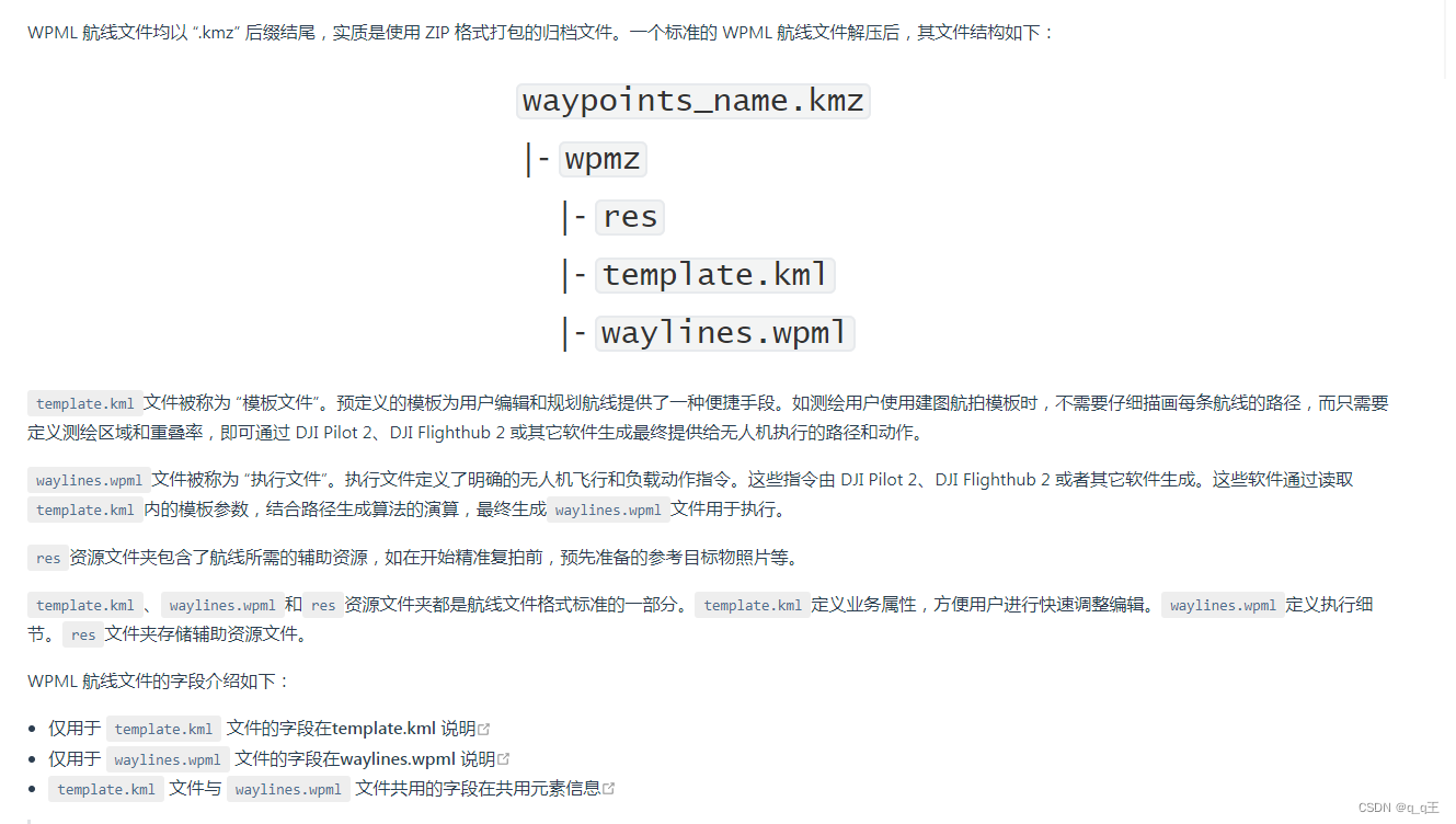
简单来说,kmz就是一个压缩包文件,里面包含了一个wpmz的文件夹,文件夹里面有两个文件,一个template.kml文件,一个waylines.wpml文件(附字段说明链接),官方文档中也有很详细的字段说明。
看完这些相信大家就有一定的思路了,只需要安装这些字段生成生成templete.kml,waylines.wpml文件,最后一起压缩成kmz文件即可。
二、开发
java端可以使用dom4j或者hutool来生成那俩子文件,当然不仅限于这两个工具,好多工具也可以实现。
/**
     * 生成航线kml文件
     *
     * @param airlineManage 航线信息
     * @return String       临时存储文件名
     */
public AirlineManage setTravelsKml(AirlineManage airlineManage) throws IOException {

    Element root = DocumentHelper.createElement("kml");
    Document document = DocumentHelper.createDocument(root);
    Namespace namespace = Namespace.get("http://www.opengis.net/kml/2.2");
    root.addAttribute("xmlns", "http://www.opengis.net/kml/2.2");
    root.add(namespace);
    Element documentElement = root.addElement("Document");
    documentElement.addElement("name").addText(airlineManage.getAirlineName()); //名称

    Element placeMarkElement = documentElement.addElement("Placemark");//在文件夹中添加一个地标
    placeMarkElement.addElement("name").addText("Wayline");
    placeMarkElement.addElement("visibility").addText("1");

    Element styleElement = placeMarkElement.addElement("Style");
    Element lineStyleElement = styleElement.addElement("LineStyle");
    lineStyleElement.addElement("color").addText("cc00ffff");
    lineStyleElement.addElement("width").addText("5");

    Element extendedData = placeMarkElement.addElement("ExtendedData");
    Element data = extendedData.addElement("Data");
    data.addAttribute("name", "LinePattern");
    data.addElement("value").addText("65535");

    // 航向间距 计算速度
    CameraInfo cameraInfo = cameraInfoMapper.selectCameraInfoByCameraId(airlineManage.getCameraId());
    double courseInterval = DrawWayPointUtil.calcNonOverlapDistance(
        airlineManage.getRelativeHeight(),
        cameraInfo.getSensorHigh(),
        cameraInfo.getCameraFocal(),
        airlineManage.getCourseOverlaps() / 100
    );
    // 默认2s
    Double photoInterval = airlineManage.getPhotoInterval();
    if (StringUtils.isNull(photoInterval) || photoInterval == 0) {
        photoInterval = 2d;
    }
    double flightSpeed = DrawWayPointUtil.calcFlightSpeed(courseInterval, photoInterval);
    extendedData.addElement("autoFlightSpeed").addText(String.valueOf(flightSpeed));


    Element lineString = placeMarkElement.addElement("LineString");
    lineString.addElement("altitudeMode").addText("clampToGround");
    Element coordinatesEle = lineString.addElement("coordinates");
    StringBuilder coordinatesBuilder = new StringBuilder();
    airlineManage.getWaypointList()
        .stream()
        .forEach(latLng -> coordinatesBuilder.append(latLng.getLon() + "," + latLng.getLat() + "," + airlineManage.getRelativeHeight() + " \n"));
    coordinatesEle.addText(coordinatesBuilder.toString());

    //创建kml到本地
    String kmlSuffix = ".kml";
    String kmlTempPath = PvConstants.PV_TEMP_FILE_PATH + airlineManage.getAirlineName() + kmlSuffix;
    File tempFile = new File(PvConstants.PV_TEMP_FILE_PATH);
    if (!tempFile.exists()) {
        tempFile.mkdirs();
    }

    OutputFormat format = OutputFormat.createPrettyPrint();
    format.setEncoding("utf-8");
    XMLWriter xmlWriter = new XMLWriter(new FileOutputStream(kmlTempPath), format);
    xmlWriter.write(document);
    xmlWriter.close();

    // 压缩
    String kmlZipSuffix = ".zip";
    String kmlZipTempPath = PvConstants.PV_TEMP_FILE_PATH + airlineManage.getAirlineName() + kmlZipSuffix;
    writeKml(Arrays.asList(kmlTempPath), kmlZipTempPath);

    String objectUrl = minioUtil.uploadObjectAndObjectUrl(airlineManage.getAirlineName() + kmlZipSuffix, kmlZipTempPath);
    airlineManage.setAirlineUrl(objectUrl);

    FileUtils.deleteFile(kmlTempPath);
    FileUtils.deleteFile(kmlZipTempPath);

    return airlineManage;
}


public static void writeKml(List<String> filePathList, String kmlName) throws IOException {
    OutputStream os = new BufferedOutputStream(new FileOutputStream(kmlName));
    ZipOutputStream zos = new ZipOutputStream(os);
    byte[] buf = new byte[8192];
    int len;
    for (String filePath : filePathList) {
        File file = new File(filePath);
        if (!file.isFile()) {
            continue;
        }
        ZipEntry ze = new ZipEntry(file.getName());
        zos.putNextEntry(ze);
        BufferedInputStream bis = new BufferedInputStream(new FileInputStream(file));
        while ((len = bis.read(buf)) > 0) {
            zos.write(buf, 0, len);
        }
        zos.closeEntry();
        bis.close();
    }

    zos.closeEntry();
    zos.close();
    os.close();
}上面代码参考别的文章(感谢大佬),生成kml文件,压缩zip。
前端只需将文件必须元素值传给后端即可,后端生成kml文件,压缩为zip文件,替换zip后缀为kmz,上传文件服务器。最后,有什么问题大家可以一同探讨,共同学习进步。


 3928
3928

 被折叠的 条评论
为什么被折叠?
被折叠的 条评论
为什么被折叠?
 到【灌水乐园】发言


