


 本文详细介绍了伽利略全球导航卫星系统(GNSS)的消息认证流程,从原始资源到具体实现,深入探讨了该过程的技术细节。
gnss
什么是GNSS? (What is a GNSS?)
GNSS (Global Navigation Satellite System) is a satellite system that is used to pinpoint the geographic location of a user’s receiver anywhere in the world. Four GNSS systems are currently in operation: the United States’ Global Positioning System (GPS), the Russian Federation’s Global Orbiting Navigation Satellite System (GLONASS), China’s BeiDou Navigation Service System (fully operational in 2020) and Europe’s Galileo. Each of the GNSS systems employs a constellation of orbiting satellites working in conjunction with a network of ground stations.
GNSS(全球导航卫星系统)是一种卫星系统,用于查明用户接收器在世界任何地方的地理位置。 目前有四个GNSS系统正在运行:美国的全球定位系统(GPS),俄罗斯联邦的全球轨道导航卫星系统(GLONASS),中国的北斗导航服务系统(将于2020年全面运行)和欧洲的伽利略。 每个GNSS系统都采用与地面站网络协同工作的轨道卫星星座。
Satellite-based navigation systems use a version of triangulation to locate the user, through calculations involving information from a number of satellites. Each satellite transmits coded signals at precise intervals. The receiver converts signal information into position, velocity, and time estimates. Using this information, any receiver on or near the earth’s surface can calculate the exact position of the transmitting satellite and the distance (from the transmission time delay) between it and the receiver. Coordinating current signal data from four or more satellites enables the receiver to determine its position.
基于卫星的导航系统使用三角测量版本,通过涉及来自许多卫星信息的计算来定位用户。 每颗卫星都以精确的间隔发送编码信号。 接收器将信号信息转换为位置,速度和时间估计。 使用此信息,地球表面上或附近的任何接收器都可以计算出发射卫星的确切位置以及它与接收器之间的距离(根据发射时间延迟)。 协调来自四个或更多卫星的当前信号数据,使接收机能够确定其位置。
The performance of GNSS is assessed using four criteria:
GNSS的性能使用以下四个标准进行评估:

Accuracy: the difference between a receiver’s measured and real position, speed or time;
精度 :接收机的测量值与实际位置,速度或时间之间的差;
Integrity: a system’s capacity to provide a threshold of confidence and, in the event of an anomaly in the positioning data, an alarm;
完整性 :系统提供置信度阈值的能力,以及在定位数据异常的情况下提供警报的能力;
Continuity: a system’s ability to function without interruption;
连续性 :系统正常运行的能力;
Availability: the percentage of time a signal fulfils the above accuracy, integrity and continuity criteria.
可用性 :信号达到上述准确性,完整性和连续性标准的时间百分比。
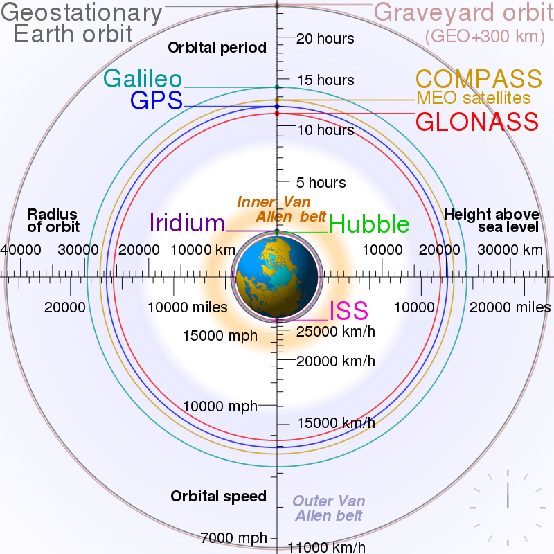
Each satellite system is positioned in a specific orbit around earth:
每个卫星系统都位于围绕地球的特定轨道中:
 最低0.47元/天 解锁文章


 613
613

 被折叠的 条评论
为什么被折叠?
被折叠的 条评论
为什么被折叠?
 到【灌水乐园】发言


