


 该数据集由Malaria Atlas Project的专家创建,通过应用Lobser和Cohen的流苏帽方程到MODIS BRDF-corrected imagery上,生成了月度约5公里分辨率的TCW数据。利用Weiss等人的方法填补了因云层等导致的数据空白。数据涵盖了2001年2月1日至2015年1月1日的时间段,可用于环境和气候研究。
This gap-filled Tasseled Cap Wetness (TCW) dataset was created by applying the tasseled-cap equations defined in Lobser and Cohen (2007) to MODIS BRDF-corrected imagery (MCD43B4). The resulting data were gap-filled using the approach outlined in Weiss et al. (2014) to eliminate missing data caused by factors such as cloud cover, and then the data were aggregated temporally and spatially to produce the monthly ≈5km product.
This dataset was produced by Harry Gibson and Daniel Weiss of the Malaria Atlas Project (Big Data Institute, University of Oxford, United Kingdom, [http://www.map.ox.ac.uk/] (http://www.map.ox.ac.uk/)).
这个填补空白的流苏帽湿润度(TCW)数据集是通过将Lobser和Cohen(2007)定义的流苏帽方程应用于MODIS BRDF校正图像(MCD43B4)而创建的。使用Weiss等人(2014)中概述的方法对所得到的数据进行填补,以消除由云层等因素造成的数据缺失,然后对数据进行时间和空间上的汇总,产生每月的≈5km产品。
该数据集由Malaria Atlas项目的Harry Gibson和Daniel Weiss制作(英国牛津大学大数据研究所,[http://www.map.ox.ac.uk/] (http://www.map.ox.ac.uk/))。
Dataset Availability
2001-02-01T00:00:00 - 2015-01-01T00:00:00
Dataset Provider
Collection Snippet
ee.ImageCollection("Oxford/MAP/TCW_5km_Monthly")
Resolution
5000 meters
Bands Table
| Name | Description | Min* | Max* | Units |
|---|---|---|---|---|
| Mean | The mean value of Tasseled Cap Wetness for each aggregated pixel. | -0.84 | 0.96 | |
| FilledProportion | A quality control band that indicates the percentage of each resulting pixel that was comprised of raw data (as opposed to gap-filled estimates). | 0 | 100 | % |
* = Values are estimated
数据引用:
Weiss, D.J., P.M. Atkinson, S. Bhatt, B. Mappin, S.I. Hay & P.W. Gething (2014) An effective approach for gap-filling continental scale remotely sensed time-series. ISPRS Journal of Photogrammetry and Remote Sensing, 98, 106-118.
Lobser, S.E. & Cohen, W.B. (2007) MODIS tasselled cap: land cover characteristics expressed through transformed MODIS data. International Journal of Remote Sensing, 28, 5079-5101.
代码:
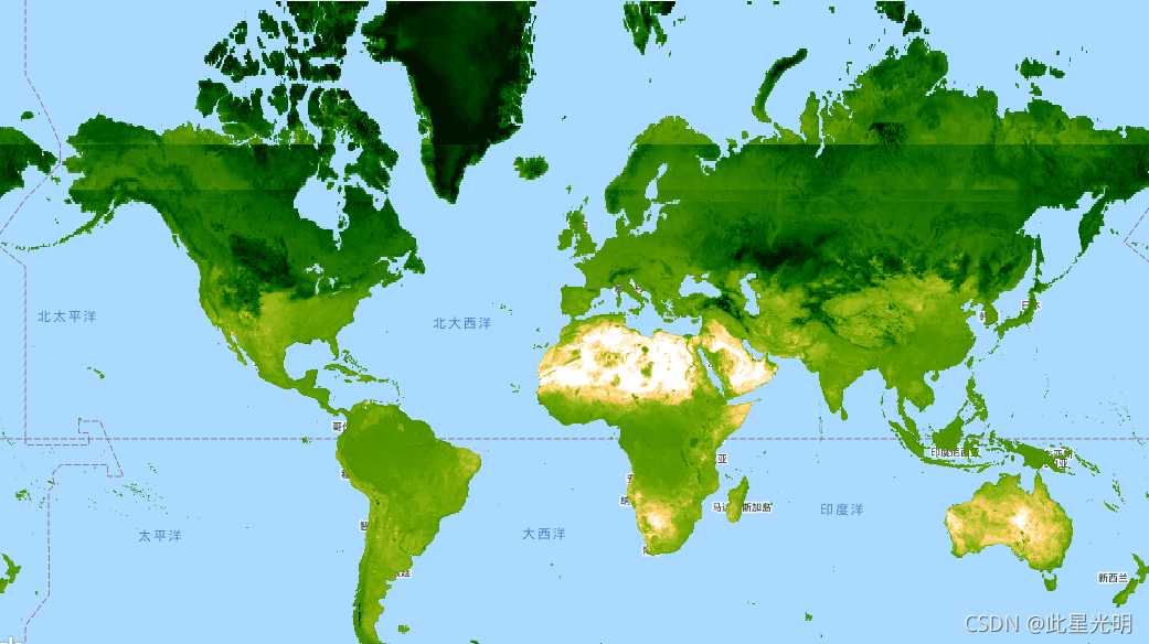
var dataset = ee.ImageCollection('Oxford/MAP/TCW_5km_Monthly')
                  .filter(ee.Filter.date('2013-01-01', '2013-12-31'));
var tcw = dataset.select('Mean');
var tcwVis = {
  min: -0.6,
  max: 0.5,
  palette: [
    'ffffff', 'fcd163', '99b718', '66a000', '3e8601', '207401', '056201',
    '004c00', '011301'
  ],
};
Map.setCenter(-44.65, 22.59, 2);
Map.addLayer(tcw, tcwVis, 'TCW');


 被折叠的 条评论
为什么被折叠?
被折叠的 条评论
为什么被折叠?
 到【灌水乐园】发言


