


SWOT 河流数据库(SWORD)
地表水和海洋地形(SWOT)卫星任务于 2022 年 12 月成功发射,通过提供大量的河流水面高程、宽度和坡度测量数据集,彻底改变了我们观测河流的能力。为了最大限度地提高这些数据的实用性和灵活性,SWOT 任务提供了各种数据产品,包括每个 SWOT 立交桥的 shapefile 格式河流矢量数据。这些矢量产品为河流系统的多时分析提供了巨大的潜力,使研究人员能够跟踪河流特征随时间的变化。
为了能够进行此类分析,在 SWOT 启动之前定义一致的河流河段和节点至关重要。这可确保来自不同河段的数据能够准确分配和比较。SWOT 河流数据库(SWORD)将与河流和卫星观测有关的多个全球数据集结合在一起,从而发挥了这一关键作用。SWORD 以 shapefile 和 netCDF 两种格式提供了高分辨率河流节点(沿河流中心线每 200 米间隔)和河段(约 10 公里的河段)的标准化框架。这些节点和河段附有一系列相关的水文变量,如水面高程、宽度、坡度以及河流障碍物、流量累积等信息。这个全面的数据集涵盖了全球 30 米宽及以上的河流,使研究人员能够对河流系统进行深入分析,并充分利用 SWOT 数据的潜力。
SWORD 整合了多个现有全球水文地理数据集的数据,包括全球陆地卫星河宽(GRWL)、MERIT Hydro、HydroBASINS 和全球河流阻塞数据库(GROD)。它为每个节点和河段提供了丰富的属性,如
位置:纬度/经度坐标、河段边界。
物理特征:水面高程、宽度、坡度、流量累积、渠道数量、障碍类型(水坝、瀑布等)。
水文模型:各种排泄量估算模型(如 MetroMan、BAM、HiVDI)的参数及相关不确定性。
SWOT 观测信息:在 21 天的轨道周期内,SWOT 经过的次数以及与每个河段交汇的具体轨道轨迹。
其他属性:河流名称、冰覆盖标志、支流标志以及表示潜在拓扑不一致或数据限制的质量标志。
数据属性
| Attribute | Description | Units |
|---|---|---|
| x | Longitude of each node ranging from 180°E to 180°W | decimal degrees |
| y | Latitude of each node, ranging from 90°S to 90°N | decimal degrees |
| node_id | Unique identifier for each node, formatted as: CBBBBBRRRRNNNT (C: Continent, B: Pfafstetter basin codes, R: Reach ID, N: Node ID within reach, T: Type) | none |
| node_length | Length of the node measured along the high-resolution centerline points | meters |
| reach_id | ID of the reach associated with each node, formatted as: CBBBBBRRRRT (C: Continent, B: Pfafstetter basin codes, R: Reach ID, T: Type) | none |
| wse | Average water surface elevation of the node | meters |
| wse_var | Variance of water surface elevation along the high-resolution centerline points used to calculate the average water surface elevation for each node | meters^2 |
| width | Average width of the node | meters |
| width_var | Variance of width along the high-resolution centerline points used to calculate the average width for each node | meters^2 |
| n_chan_max | Maximum number of channels observed within the node | none |
| n_chan_mod | Mode (most frequent) number of channels observed within the node | none |
| obstr_type | Type of obstruction at the node based on GROD and HydroFALLS databases: 0 - No Dam, 1 - Dam, 2 - Lock, 3 - Low Permeable Dam, 4 - Waterfall | none |
| grod_id | Unique GROD ID for nodes with obstr_type values 1-3 | none |
| hfalls_id | Unique HydroFALLS ID for nodes with obstr_type value 4 | none |
| dist_out | Distance from the river outlet to the node | meters |
| type | Node type identifier: 1 - River, 3 - Lake on river, 4 - Dam/waterfall, 5 - Unreliable topology, 6 - Ghost node | none |
| facc | Maximum flow accumulation value for the node | kilometers^2 |
| lakeflag | GRWL water body identifier: 0 - River, 1 - Lake/reservoir, 2 - Canal, 3 - Tidally influenced river | none |
| max_width | Maximum width across the channel for the node, including islands and bars | meters |
| river_name | All river names associated with the node (separated by semicolons if multiple) | none |
| sinuosity | Ratio of total reach length to the straight-line distance between reach endpoints, indicating the degree of meandering | none |
| meand_len | Average length of meanders the node belongs to | meters |
| manual_add | Binary flag indicating if the node was manually added to GRWL centerlines (1) or not (0) | none |
| trib_flag | Binary flag indicating if a large tributary not in SWORD enters the node (1) or not (0) | none |
| Attribute | Description | Units |
|---|---|---|
| x | Longitude of the reach center point (ranging from 180°E to 180°W) | decimal degrees |
| y | Latitude of the reach center point (ranging from 90°S to 90°N) | decimal degrees |
| reach_id | Unique identifier for each reach, formatted as: CBBBBBRRRRT (C: Continent, B: Pfafstetter basin codes, R: Reach ID, T: Type) | none |
| reach_length | Length of the reach measured along the high-resolution centerline points | meters |
| wse | Average water surface elevation of the reach | meters |
| wse_var | Variance of water surface elevation along the high-resolution centerline points used to calculate the average water surface elevation for each reach | meters^2 |
| width | Average width of the reach | meters |
| width_var | Variance of width along the high-resolution centerline points used to calculate the average width for each reach | meters^2 |
| n_nodes | Number of nodes associated with the reach | none |
| n_chan_max | Maximum number of channels observed within the reach | none |
| n_chan_mod | Mode (most frequent) number of channels observed within the reach | none |
| obstr_type | Type of obstruction within the reach based on GROD and HydroFALLS databases: 0 - No Dam, 1 - Dam, 2 - Lock, 3 - Low Permeable Dam, 4 - Waterfall | none |
| grod_id | Unique GROD ID for reaches with obstr_type values 1-3 | none |
| hfalls_id | Unique HydroFALLS ID for reaches with obstr_type value 4 | none |
| slope | Average slope of the reach calculated along the high-resolution centerline points | m/km |
| dist_out | Distance from the river outlet to the reach | meters |
| n_rch_up | Number of upstream reaches connected to this reach | none |
| n_rch_down | Number of downstream reaches connected to this reach | none |
| rch_id_up | IDs of the upstream reaches connected to this reach | none |
| rch_id_dn | IDs of the downstream reaches connected to this reach | none |
| lakeflag | GRWL water body identifier: 0 - River, 1 - Lake/reservoir, 2 - Canal, 3 - Tidally influenced river | none |
| max_width | Maximum width across the channel for the reach, including islands and bars | meters |
| type | Reach type identifier: 1 - River, 3 - Lake on river, 4 - Dam/waterfall, 5 - Unreliable topology, 6 - Ghost reach | none |
| facc | Maximum flow accumulation value for the reach | kilometers^2 |
| swot_obs | Maximum number of SWOT passes intersecting the reach during the 21-day orbit cycle | none |
| swot_orbits | List of SWOT orbit track numbers that intersect the reach during the 21-day cycle | none |
| river_name | All river names associated with the reach (separated by semicolons if multiple) | none |
| trib_flag | Binary flag indicating if a large tributary not in SWORD enters the reach (1) or not (0) | none |
数据处理
海域和节点形状文件数据集已下载压缩,并作为单独的形状文件上传。然后合并文件夹资产,创建单一的节点和河段文件。形状文件中的属性按原样保留。
数据引用
Altenau et al., (2021) The Surface Water and Ocean Topography (SWOT) Mission River Database (SWORD): A Global River Network for Satellite Data
Products. Water Resources Research. https://doi.org/10.1029/2021WR030054
Elizabeth H. Altenau, Tamlin M. Pavelsky, Michael T. Durand, Xiao Yang, Renato P. d. M. Frasson, & Liam Bendezu. (2023). SWOT River Database (SWORD)
(Version v16) [Data set]. Zenodo. https://doi.org/10.5281/zenodo.10013982
代码
var nodes_merged = ee.FeatureCollection("projects/sat-io/open-datasets/SWORD/nodes_merged");
var reaches_merged = ee.FeatureCollection("projects/sat-io/open-datasets/SWORD/reaches_merged");
// Define different styles for each FeatureCollection
var nodeStyle = {
color: 'red',
width: 2
};
var reachStyle = {
color: 'blue',
width: 1
};
// Add each FeatureCollection with its own style
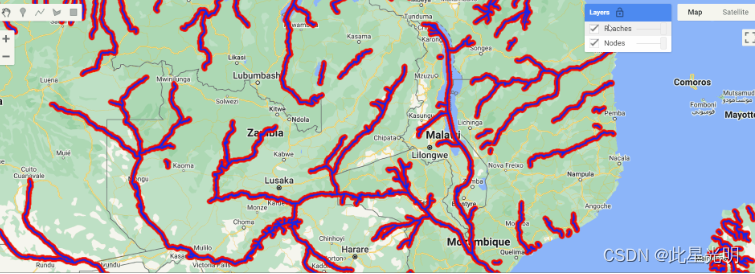
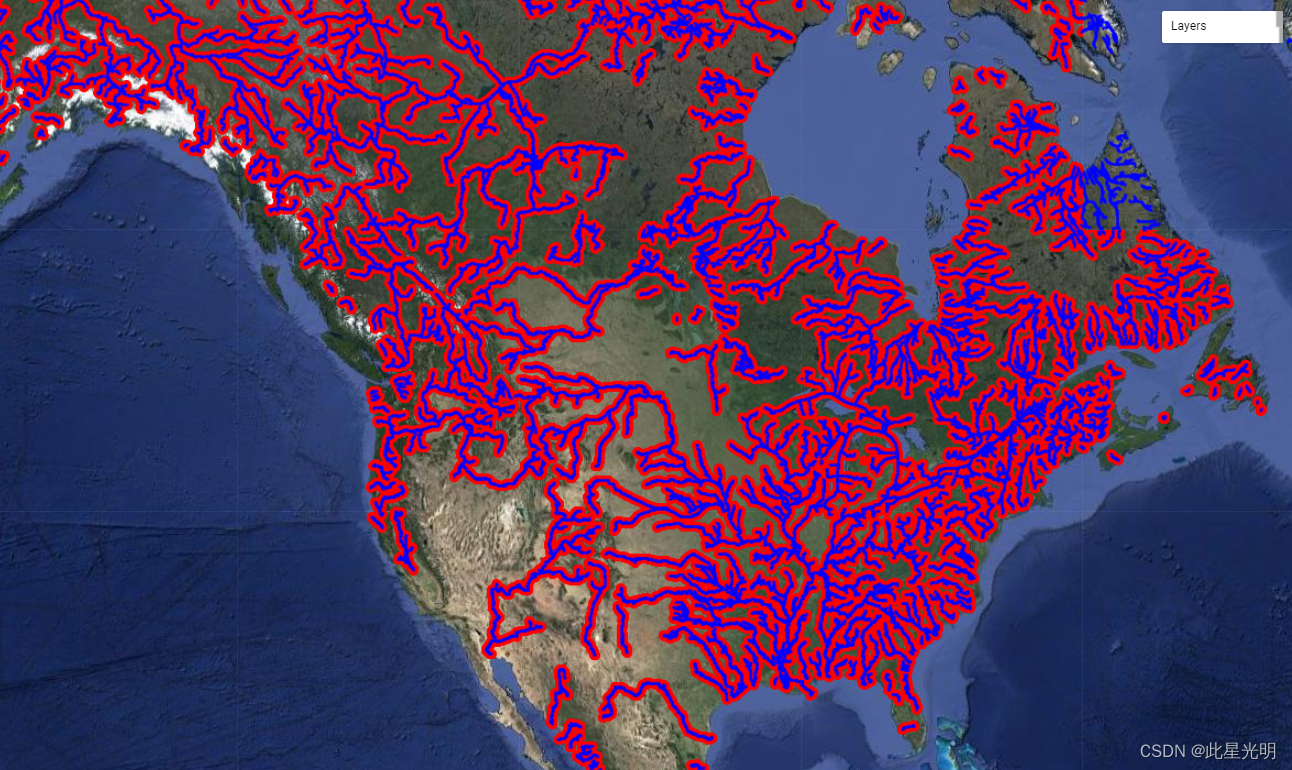
Map.addLayer(nodes_merged, nodeStyle, 'Nodes');
Map.addLayer(reaches_merged, reachStyle, 'Reaches');
代码链接
单个节点和达到文件已被摄入供参考,用户可通过使用
var ee_nodes = ee.data.listAssets("projects/sat-io/open-datasets/SWORD/nodes");
var ee_reaches = ee.data.listAssets("projects/sat-io/open-datasets/SWORD/reaches");

print('Total of '+ee.List(ee_nodes.assets).size().getInfo()+ ' assets in nodes',ee_nodes.assets);
print('Total of '+ee.List(ee_reaches.assets).size().getInfo()+ ' reaches in nodes',ee_reaches.assets);
代码链接
License
The datasets are provided under a Creative Commons 4.0 International License.
Provided by: Altenau et al., (2021)
Curated in GEE by: Samapriya Roy
Keywords: SWORD,SWOT,Rivers,Hydrology,Hydrography,River Networks,Global
Last updated in GEE: 2024-04-12
Copyright © 2020 - 2024 Samapriya Roy


 1158
1158

 被折叠的 条评论
为什么被折叠?
被折叠的 条评论
为什么被折叠?
 到【灌水乐园】发言


