


 本文介绍了一种利用PALSAR-2/PALSAR SAR影像生成全球25米分辨率森林/非森林地图的方法。该方法通过分类SAR图像的后向散射系数来区分森林与非森林区域,并采用与区域相关的后向散射阈值提高分类准确性。
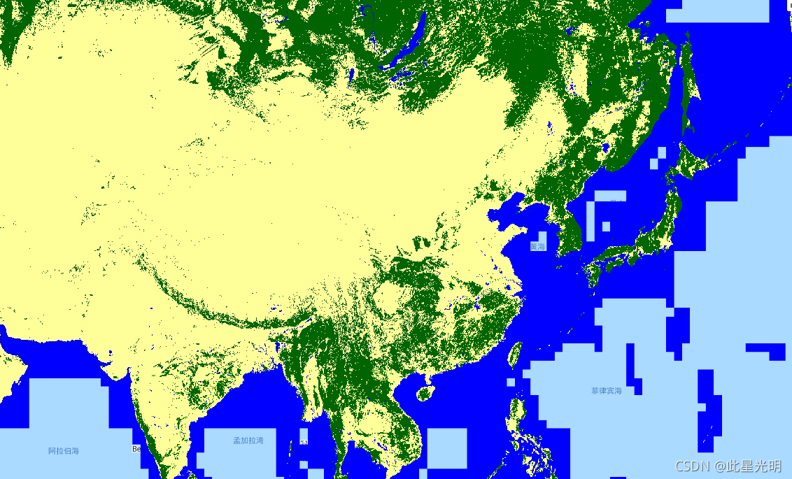
The global forest/non-forest map (FNF) is generated by classifying the SAR image (backscattering coefficient) in the global 25m resolution PALSAR-2/PALSAR SAR mosaic so that strong and low backscatter pixels are assigned as "forest" and "non-forest", respectively. Here, "forest" is defined as the natural forest with the area larger than 0.5 ha and forest cover over 10%. This definition is the same as the Food and Agriculture Organization (FAO) definition. Since the radar backscatter from the forest depends on the region (climate zone), the classification of Forest/Non-Forest is conducted by using a region-dependent threshold of backscatter. The classification accuracy is checked by using in-situ photos and high-resolution optical satellite images. Detailed information is available in the provider's Dataset Description.
Attention:
- Backscatter values may vary significantly from path to path over high latitude forest areas. This is due to the change of backscattering intensity caused by freezing trees in winter. Please note that this may affect the classification of forest/non-forest.
全球森林/非森林地图(FNF)是通过对全球 25m 分辨率 PALSAR-2/PALSAR SAR 马赛克中的 SAR 影像(后向散射系数)进行分类,从而将强和低后向散射像素分配为“森林”和“非-森林”,分别。这里的“森林”是指面积大于0.5公顷、森林覆盖率超过10%的天然林。该定义与粮食及农业组织 (FAO) 的定义相同。由于来自森林的雷达后向散射取决于区域(气候带),因此使用与区域相关的后向散射阈值来进行森林/非森林的分类。通过使用原位照片和高分辨率光学卫星图像检查分类精度。提供者的数据集描述中提供了详细信息。

注意力:

在高纬度森林地区,不同路径的反向散射值可能会有很大差异。这是由于冬季树木结冰引起后向散射强度的变化。请注意,这可能会影响森林/非森林的分类。
Dataset Availability
2007-01-01T00:00:00 - 2018-01-01T00:00:00
Dataset Provider
Collection Snippet
ee.ImageCollection("JAXA/ALOS/PALSAR/YEARLY/FNF")
Resolution
25 meters
Bands Table
| Name | Description | Min | Max |
|---|---|---|---|
| fnf | Forest/Non-Forest landcover classification | 1 | 3 |
Class Table: fnf
| Value | Color | Color Value | Description |
|---|---|---|---|
| 1 | #006400 | Forest | |
| 2 | #FEFF99 | Non-Forest | |
| 3 | #0000FF | Water |
数据说明:JAXA retains ownership of the dataset and cannot guarantee any problem caused by or possibly caused by using the datasets. Anyone wishing to publish any results using the datasets should clearly acknowledge the ownership of the data in the publication.
引用:
Masanobu Shimada, Takuya Itoh, Takeshi Motooka, Manabu Watanabe, Shiraishi Tomohiro, Rajesh Thapa, and Richard Lucas, "New Global Forest/Non-forest Maps from ALOS PALSAR Data (2007-2010)", Remote Sensing of Environment, 155, pp. 13-31, December 2014. doi:10.1016/j.rse.2014.04.014.
代码:
var dataset = ee.ImageCollection('JAXA/ALOS/PALSAR/YEARLY/FNF')
                  .filterDate('2017-01-01', '2017-12-31');
var forestNonForest = dataset.select('fnf');
var forestNonForestVis = {
  min: 1.0,
  max: 3.0,
  palette: ['006400', 'FEFF99', '0000FF'],
};
Map.setCenter(136.85, 37.37, 4);
Map.addLayer(forestNonForest, forestNonForestVis, 'Forest/Non-Forest');


 1206
1206

 被折叠的 条评论
为什么被折叠?
被折叠的 条评论
为什么被折叠?
 到【灌水乐园】发言


