


哥白尼数字高程模型(GLO-30 DEM)
哥白尼DEM是一个数字表面模型(DSM),代表了地球的表面,包括建筑物、基础设施和植被。我们提供两种哥白尼DEM的实例,分别是GLO-30 Public和GLO-90。GLO-90提供90米的全球覆盖。GLO-30公共版提供有限的30米的全球覆盖,因为哥白尼计划还没有向公众发布覆盖特定国家的一小部分瓦片。请注意,在这两种情况下,海洋地区都没有瓦片,在那里可以假设高度值等于零。数据以云优化GeoTIFF的形式提供,并从亚马逊开放注册处下载。
Copernicus Digital Elevation Model (DEM) - Registry of Open Data on AWS
原始瓦片与相邻的瓦片共享一行或一列,其尺寸为3601×3601像素、2401×2401像素、1801×1801像素或其他,取决于经度。我们去掉了东边和南边的这些共享的行和列,得到了很好的可被两除的尺寸,所以我们可以创建漂亮的COG概述。COG文件的共同属性是:使用浮点预测器的DEFLATE压缩(PREDICTOR=3);平均下抽样 。
有关具体数据信息可以查看这个:
Copernicus Digital Elevation Model datasets
数据引用:
Copernicus Digital Elevation Model (DEM) was accessed on DATE from
Earth Engine Snippet
var countries = ee.FeatureCollection("FAO/GAUL/2015/level0"),
    glo30 = ee.ImageCollection("projects/sat-io/open-datasets/GLO-30");

print('GLO-30 Collection size :',glo30.size())

//Explanation on setting default Projection here https://twitter.com/jstnbraaten/status/1494038930643042309
var elev = glo30.mosaic().setDefaultProjection('EPSG:3857',null,30)

//you can also use this incase you don't want to specify CRS
//var elev = glo30.mosaic().setDefaultProjection(glo30.first().projection())


// Create an "ocean" variable to be used for cartographic purposes
var ocean = elev.lte(0);

// Create a custom elevation palette from hex strings.
var elevationPalette = ['006600', '002200', 'fff700', 'ab7634', 'c4d0ff', 'ffffff'];

// Use these visualization parameters, customized by location.
var visParams = {min: 1, max: 3000, palette: elevationPalette};

// Create a mosaic of the ocean and the elevation data
var visualized = ee.ImageCollection([
  // Mask the elevation to get only land
  elev.mask(ocean.not()).visualize(visParams),
  // Use the ocean mask directly to display ocean.
  ocean.mask(ocean).visualize({palette:'000022'})
]).mosaic();

// Note that the visualization image doesn't require visualization parameters.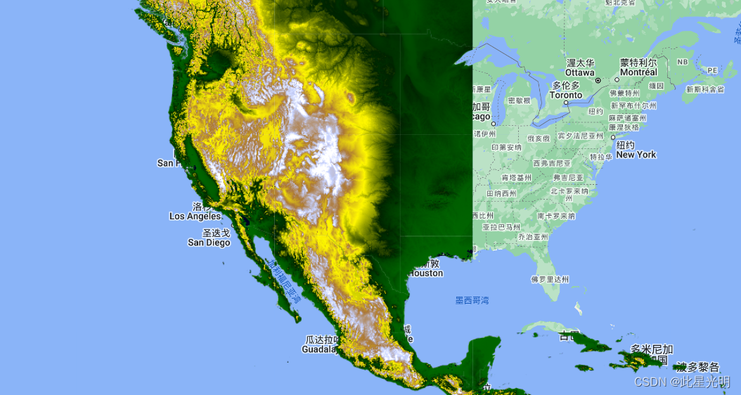
Map.addLayer(visualized.clip(countries), {}, 'elev palette');Earth Engine comparison app: glob-elevation
License
GLO-30 Public is available on a free basis for the general public under the terms and conditions of the license found here.
© DLR e.V. 2010-2014 and © Airbus Defence and Space GmbH 2014-2018 provided under COPERNICUS by the European Union and ESA; all rights reserved.
Disclaimer
The organisations in charge of the Copernicus programme by law or by delegation do not incur any liability for any use of the Copernicus WorldDEM-30.See Article 6© in https://docs.sentinel-hub.com/api/latest/static/files/data/dem/resources/license/License-COPDEM-30.pdf
Created by: European Space Agency, COPERNICUS
Curated in GEE by: Samapriya Roy
Keywords: digital elevation model, terrain, remote sensing, esa, copernicus


 454
454

 被折叠的 条评论
为什么被折叠?
被折叠的 条评论
为什么被折叠?
 到【灌水乐园】发言


