


简介
从2023年12月4日起,NASA/SMAP/SPL3SMP_E/006 数据集中的数据可用。
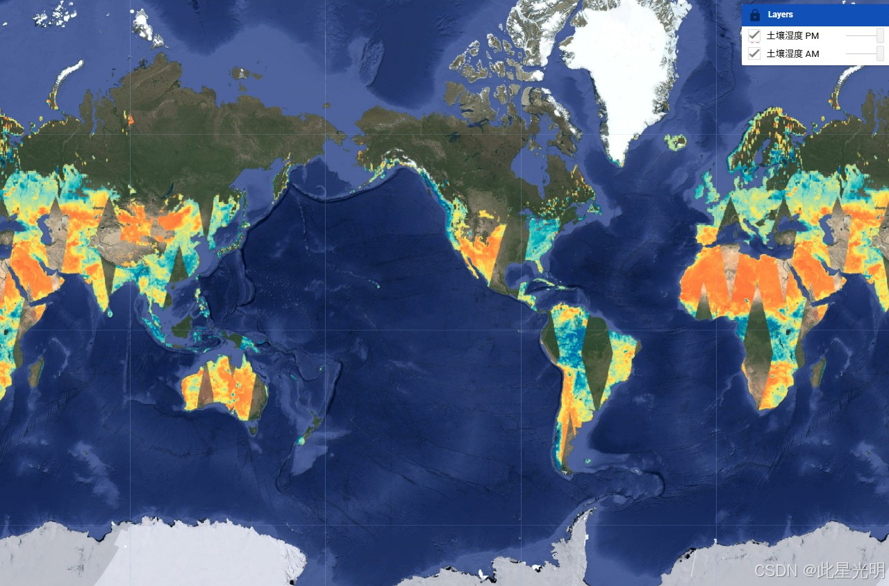
该三级(L3)土壤湿度产品提供了通过土壤湿度主动被动(SMAP)L波段辐射计获取的全球陆地表面状况的每日合成数据。这里的每日数据是从下行通道(当地太阳时间上午6点)和上行通道(当地太阳时间下午6点)收集的。
SMAP任务是一个轨道观测站,测量地球表层土壤中的水分含量。详细描述可以在SMAP手册中找到。该任务于2015年1月发射,并于2015年4月开始运行。由于雷达电源故障,雷达仪器在2015年初停止运行,收集了近三个月的科学数据。主要任务阶段为期三年,于2018年完成,从那时起,SMAP进入了扩展运行阶段。
SMAP每2-3天测量一次土壤湿度。这使得能够观察全球范围内的变化,时间尺度从重大风暴到季节性变化的重复测量。
在地球上,所有未被水覆盖或未冻结的地方,SMAP测量表层土壤中的水分含量。它还区分冻结或解冻的地面。在地面未冻结的地方,SMAP测量土壤中矿物质、岩石材料和有机颗粒之间的水分含量(SMAP测量表层土壤中的液态水,但无法测量冰)。
SPL3SMP_E 数据在被导入 Google Earth Engine 之前,使用 GDAL 库转换为地理坐标。
有关更多文档和算法细节,请参见 SMAP L3 土壤湿度用户指南及其中的参考资料。
请查看基础和高级教程,以了解如何在 Earth Engine 中使用 SMAP 数据。
数据集说明
空间信息
Dataset Availability
2015-03-31T12:00:00 - 2023-12-03T12:00:00
Dataset Provider
Collection Snippet
ee.ImageCollection("NASA/SMAP/SPL3SMP_E/005")
变量
Resolution
9000 meters
Bands Table
| Name | Description | Min | Max | Units |
|---|---|---|---|---|
| soil_moisture_am | Retrieved soil moisture estimate from the disaggregated/downscaled vertical polarization brightness temperature at 9-km grid cell; AM overpass | Volume fraction | ||
| tb_h_corrected_am | Weighted average of horizontally polarized brightness temperatures. This value represents the corrected land brightness temperature if the water fraction is lower than 0.9 (otherwise no correction is applied) or represents the corrected water brightness temperature if the water fraction is greater than 0.1 (otherwise no correction is applied); AM overpass | 0 | 330 | K |
| tb_v_corrected_am | Weighted average of vertically polarized brightness temperatures. This value represents the corrected land brightness temperature if the water fraction is lower than 0.9 (otherwise no correction is applied) or represents the corrected water brightness temperature if the water fraction is greater than 0.1 (otherwise no correction is applied); AM overpass | 0 | 330 | K |
| vegetation_water_content_am | Vegetation water content at 9-km spatial scale. This parameter is used as input ancillary data parameter to the SPL2SMAP processing software when the baseline algorithm is used. The valid minimum and maximum below are subject to further analysis. AM overpass | 0 | 30 | kg/m^2 |
| retrieval_qual_flag_am | 0 = Pass: Soil moisture with acceptable quality; 1 = Fail: Soil moisture does with unacceptable quality; AM overpass | 0 | 65536 | |
| tb_qual_flag_h_am | 0= brightness temperatures with unacceptable quality; 1= brightness temperatures with acceptable quality; AM overpass | 0 | 65536 | |
| tb_qual_flag_v_am | 0= brightness temperatures with unacceptable quality; 1= brightness temperatures with acceptable quality; AM overpass | 0 | 65536 | |
| soil_moisture_pm | Retrieved soil moisture estimate from the disaggregated/downscaled vertical polarization brightness temperature at 9-km grid cell; PM overpass | Volume fraction | ||
| tb_h_corrected_pm | Weighted average of horizontally polarized brightness temperatures. This value represents the corrected land brightness temperature if the water fraction is lower than 0.9 (otherwise no correction is applied) or represents the corrected water brightness temperature if the water fraction is greater than 0.1 (otherwise no correction is applied); PM overpass | 0 | 330 | K |
| tb_v_corrected_pm | Weighted average of vertically polarized brightness temperatures. This value represents the corrected land brightness temperature if the water fraction is lower than 0.9 (otherwise no correction is applied) or represents the corrected water brightness temperature if the water fraction is greater than 0.1 (otherwise no correction is applied); PM overpass | 0 | 330 | K |
| vegetation_water_content_pm | Vegetation water content at 9-km spatial scale. This parameter is used as input ancillary data parameter to the SPL2SMAP processing software when the baseline algorithm is used. The valid minimum and maximum below are subject to further analysis. PM overpass | 0 | 30 | kg/m^2 |
| retrieval_qual_flag_pm | 0 = Pass: Soil moisture with acceptable quality; 1 = Fail: Soil moisture does with unacceptable quality; PM overpass | 0 | 65536 | |
| tb_qual_flag_h_pm | 0= brightness temperatures with unacceptable quality; 1= brightness temperatures with acceptable quality; PM overpass | 0 | 65536 | |
| tb_qual_flag_v_pm | 0= brightness temperatures with unacceptable quality; 1= brightness temperatures with acceptable quality; PM overpass | 0 | 65536 | |
| soil_moisture_am_anomaly | Experimental. Difference of the 30-day average of 'soil_moisture_am', centered on asset date, relative to the same 30-day period averaged across years from 2015 to present, excluding asset year. See this script for anomaly computations. | |||
| soil_moisture_pm_anomaly | Experimental. Difference of the 30-day average of 'soil_moisture_pm', centered on asset date, relative to the same 30-day period averaged across years from 2015 to present, excluding asset year. See this script for anomaly computations. |
代码
// 读取图像集合并获取第一幅图像
var era5_heat_ic = ee.ImageCollection('projects/climate-engine-pro/assets/ce-era5-heat')
var era5_heat_i = era5_heat_ic.first()

// 打印第一幅图像,查看波段
print(era5_heat_i)

// 可视化第一幅图像中的选定波段 - 其他波段存在于图像集合中
var temp_palette = ["#b2182b", "#ef8a62", "#fddbc7", "#f7f7f7", "#d1e5f0", "#67a9cf", "#2166ac"].reverse()
Map.addLayer(era5_heat_i.select('mrt_mean').selfMask().subtract(273.15), {min: -10, max: 50, palette: temp_palette}, 'Mean Radiant Temperature, Daily Mean')
Map.addLayer(era5_heat_i.select('utci_mean').selfMask().subtract(273.15), {min: -10, max: 50, palette: temp_palette}, 'Universal Thermal Climate Index, Daily Mean')
代码链接
https://code.earthengine.google.com/f7396add81bcc47736abf0b8cf0abf1a
结果
引用
**O'Neill, P. E., S. Chan, E. G. Njoku, T. Jackson, R. Bindlish, J. Chaubell, and A. Colliander. 2021. SMAP Enhanced L3 Radiometer Global and Polar Grid Daily 9 km EASE-Grid Soil Moisture, Version 5. [Indicate subset used]. Boulder, Colorado USA. NASA National Snow and Ice Data Center Distributed Active Archive Center. doi:10.5067/4DQ54OUIJ9DL
Entekhabi et al., 2014 D. Entekhabi, S. Yueh, P. O'Neill, K. Kellogg et al. SMAP Handbook - Soil Moisture Active Passive: Mapping Soil Moisture and Freeze/thaw From Space. SMAP Project, Jet Propulsion Laboratory, Pasadena, CA (2014) SMAP Handbook
Chan, S. K., R. Bindlish, P. E. O'Neill, E. Njoku, T. Jackson, A. Colliander, F. Chen, M. Burgin, S. Dunbar, J. Piepmeier, S. Yueh, D. Entekhabi, M. H. Cosh, T. Caldwell, J. Walker, X. Wu, A. Berg, T. Rowlandson, A. Pacheco, H. McNairn, M. Thibeault, J. Martinez-Fernandez, A. Gonzalez-Zamora, M. Seyfried, D. Bosch, P. Starks, D. Goodrich, J. Prueger, M. Palecki, E. E. Small, M. Zreda, J.-C. Calvet, W. T. Crow, and Y. Kerr. 2016. "Assessment of the SMAP Passive Soil Moisture Product" IEEE Transactions on Geoscience and Remote Sensing, 54 (8): 4994-5007 10.1109/tgrs.2016.2561938
Chan, S., R. Bindlish, P. O'Neill, T. Jackson, E. Njoku, S. Dunbar, J. Chaubell, J. Piepmeier, S. Yueh, D. Entekhabi, A. Colliander, F. Chen, M. Cosh, T. Caldwell, J. Walker, A. Berg, H. McNairn, M. Thibeault, J. Martínez-Fernández, F. Uldall, M. Seyfried, D. Bosch, P. Starks, C. Holifield Collins, J. Prueger, R. van der Velde, J. Asanuma, M. Palecki, E. Small, M. Zreda, J. Calvet, W. Crow, and Y. Kerr. 2018. "Development and assessment of the SMAP enhanced passive soil moisture product." Remote Sensing of Environment, 204: 931-941 10.1016/j.rse.2017.08.025
许可
Assessment of the SMAP Passive Soil Moisture Product | IEEE Journals & Magazine | IEEE Xplore
网址推荐
机器学习
干旱监测平台
慧天干旱监测与预警-首页https://www.htdrought.com/https://www.htdrought.com/![]() https://www.htdrought.com/
https://www.htdrought.com/


 被折叠的 条评论
为什么被折叠?
被折叠的 条评论
为什么被折叠?
 到【灌水乐园】发言


