


maxPixels
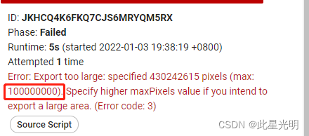
该maxPixels参数旨在防止无意中创建非常大的导出。如果默认值对于您想要的输出图像来说太低,您可以增加maxPixels. 例如:
Export.image.toDrive({
  image: landsat,
  description: 'maxPixelsExample',
  scale: 30,
  region: geometry,
  maxPixels: 1e9//改变这个参数可以让你的下载量成10倍百倍千倍的增加
});
导出硬盘的函数:
Export.image.toDrive(image, description, folder, fileNamePrefix, dimensions, region, scale, crs, crsTransform, maxPixels, shardSize, fileDimensions, skipEmptyTiles, fileFormat, formatOptions)
Creates a batch task to export an Image as a raster to Drive. Tasks can be started from the Tasks tab. "crsTransform", "scale", and "dimensions" are mutually exclusive.
创建一个批处理任务,将图像作为栅格导出到驱动器。任务可以从 "任务 "选项卡开始。"crsTransform"、"scale "和 "dimensions "是相互排斥的。
Arguments:
image (Image):
The image to export.
description (String, optional):
A human-readable name of the task. May contain letters, numbers, -, _ (no spaces). Defaults to "myExportImageTask".
folder (String, optional):
The Google Drive Folder that the export will reside in. Note: (a) if the folder name exists at any level, the output is written to it, (b) if duplicate folder names exist, output is written to the most recently modified folder, (c) if the folder name does not exist, a new folder will be created at the root, and (d) folder names with separators (e.g. 'path/to/file') are interpreted as literal strings, not system paths. Defaults to Drive root.
fileNamePrefix (String, optional):
The filename prefix. May contain letters, numbers, -, _ (no spaces). Defaults to the description.
dimensions (Number|String, optional):
The dimensions to use for the exported image. Takes either a single positive integer as the maximum dimension or "WIDTHxHEIGHT" where WIDTH and HEIGHT are each positive integers.
region (Geometry.LinearRing|Geometry.Polygon|String, optional):
A LinearRing, Polygon, or coordinates representing region to export. These may be specified as the Geometry objects or coordinates serialized as a string. If not specified, the region defaults to the viewport at the time of invocation.
scale (Number, optional):
Resolution in meters per pixel. Defaults to 1000.
crs (String, optional):
CRS to use for the exported image.
crsTransform (List<Number>|String, optional):
Affine transform to use for the exported image. Requires "crs" to be defined.
maxPixels (Number, optional):
Restrict the number of pixels in the export. By default, you will see an error if the export exceeds 1e8 pixels. Setting this value explicitly allows one to raise or lower this limit.这里最大可以设置为1e13,
shardSize (Number, optional):
Size in pixels of the tiles in which this image will be computed. Defaults to 256.
fileDimensions (List<Number>|Number, optional):
The dimensions in pixels of each image file, if the image is too large to fit in a single file. May specify a single number to indicate a square shape, or an array of two dimensions to indicate (width,height). Note that the image will still be clipped to the overall image dimensions. Must be a multiple of shardSize.
skipEmptyTiles (Boolean, optional):
If true, skip writing empty (i.e. fully-masked) image tiles. Defaults to false.
fileFormat (String, optional):
The string file format to which the image is exported. Currently only 'GeoTIFF' and 'TFRecord' are supported, defaults to 'GeoTIFF'.
formatOptions (ImageExportFormatConfig, optional):
A dictionary of string keys to format specific options.
大文件导出编码
如果输出图像很大,它将导出为多个文件。如果您要导出到 GeoTIFF(s),图像将被拆分为多个图块。每个图块的文件名将采用以下格式baseFilename-yMin-xMin,其中xMin和 yMin是导出图像整体边界框中每个图块的坐标。
如果您要导出到 TFRecord,对于N+1 个文件,文件将附加-00000, -00001,...。如果您打算对文件执行推理并将预测作为图像上传回 Earth Engine,则保持此顺序很重要。有关详细信息,请参阅将图像上传为 TFRecord 文件 https://developers.google.com/earth-engine/guides/image_upload#tfrecord。
导出在代码编辑器中显示的图像
要导出在 Earth Engine 中呈现在屏幕上的图像,请按照可视化图像以及合成和镶嵌部分中的演示创建可视化图像。由于代码编辑器使用'EPSG:3857'CRS,因此'EPSG:3857'在导出中指定 CRS 以获得与代码编辑器地图中显示的投影相同的图像。有关指定输出分辨率和坐标系的详细信息,请参阅配置图像导出部分https://developers.google.com/earth-engine/guides/exporting#configuration-parameters感谢家人们对我的肯定,成功入围云计算领域前5,我将一如既往的给大家推送优质内容:


 1989
1989

 被折叠的 条评论
为什么被折叠?
被折叠的 条评论
为什么被折叠?
 到【灌水乐园】发言


