


The Ocean and Land Color Instrument (OLCI) Earth Observation Full Resolution (EFR) dataset contains top of atmosphere radiances at 21 spectral bands with center wavelengths ranging between 0.4μm and 1.02μm at spatial resolution of 300m with worldwide coverage every ~2 days.
OLCI is one of the instruments in the ESA/EUMETSAT Sentinel-3 mission for measuring sea-surface topography, sea- and land-surface temperature, ocean color and land color with high-end accuracy and reliability to support ocean forecasting systems, as well as environmental and climate monitoring.
The Sentinel-3 OLCI instrument is based on the optomechanical and imaging design of ENVISAT's MERIS. It is designed to retrieve the spectral distribution of upwelling radiance just above the sea surface (the water-leaving radiance).
OLCI observation is performed simultaneously in 21 spectral bands ranging from the visible to the near-infrared (400 to 1029nm).
海洋和陆地颜色仪器 (OLCI) 地球观测全分辨率 (EFR) 数据集包含 21 个光谱带的顶部大气辐射,中心波长范围在 0.4μm 和 1.02μm 之间,空间分辨率为 300m,全球每约 2 天覆盖一次。
OLCI 是 ESA/EUMETSAT Sentinel-3 任务中的仪器之一,用于测量海面地形、海陆表面温度、海洋颜色和陆地颜色,具有高端的准确性和可靠性,以支持海洋预报系统,以及作为环境和气候监测。
Sentinel-3 OLCI 仪器基于 ENVISAT 的 MERIS 的光机械和成像设计。它旨在检索刚好在海面上方的上升流辐射(离开水的辐射)的光谱分布。
OLCI 观测在从可见光到近红外(400 到 1029nm)的 21 个光谱带中同时进行。
Dataset Availability
2016-10-18T19:25:42 - 2021-09-02T00:00:00
Dataset Provider
Collection Snippet
ee.ImageCollection("COPERNICUS/S3/OLCI")
Resolution
300 meters
Bands Table
| Name | Description | Units | Wavelength | Scale |
|---|---|---|---|---|
| Oa01_radiance | Aerosol correction, improved water constituent retrieval | W m^-2 sr^-1 μm^-1 | 400nm/15nm | 0.01394646 |
| Oa02_radiance | Yellow substance and detrital pigments (turbidity) | W m^-2 sr^-1 μm^-1 | 412.5nm/10nm | 0.01338726 |
| Oa03_radiance | Chl absorption max., biogeochemistry, vegetation | W m^-2 sr^-1 μm^-1 | 442.5nm/10nm | 0.01214812 |
| Oa04_radiance | High Chl, other pigments | W m^-2 sr^-1 μm^-1 | 490nm/10nm | 0.01151982 |
| Oa05_radiance | Chl, sediment, turbidity, red tide | W m^-2 sr^-1 μm^-1 | 510nm/10nm | 0.01009526 |
| Oa06_radiance | Chlorophyll reference (Chl minimum) | W m^-2 sr^-1 μm^-1 | 560nm/10nm | 0.0123538 |
| Oa07_radiance | Sediment loading | W m^-2 sr^-1 μm^-1 | 620nm/10nm | 0.00879161 |
| Oa08_radiance | Chl (2^nd Chl abs. max.), sediment, yellow substance/vegetation | W m^-2 sr^-1 μm^-1 | 665nm/10nm | 0.00876539 |
| Oa09_radiance | For improved fluorescence retrieval and to better account for [smile](https://sentinels.copernicus.eu/web/sentinel/technical-guides/sentinel-3-olci/level-2/smile-correction) together with the bands 665 and 680nm | W m^-2 sr^-1 μm^-1 | 673.75nm/7.5nm | 0.0095103 |
| Oa10_radiance | Chl fluorescence peak, red edge | W m^-2 sr^-1 μm^-1 | 681.25nm/7.5nm | 0.00773378 |
| Oa11_radiance | Chl fluorescence baseline, red edge transition | W m^-2 sr^-1 μm^-1 | 708.75nm/10nm | 0.00675523 |
| Oa12_radiance | O2 absorption/clouds, vegetation | W m^-2 sr^-1 μm^-1 | 753.75nm/7.5nm | 0.0071996 |
| Oa13_radiance | O2 absorption band/aerosol correction | W m^-2 sr^-1 μm^-1 | 761.25nm/7.5nm | 0.00749684 |
| Oa14_radiance | Atmospheric correction | W m^-2 sr^-1 μm^-1 | 764.375nm/3.75nm | 0.0086512 |
| Oa15_radiance | O2A used for cloud top pressure, fluorescence over land | W m^-2 sr^-1 μm^-1 | 767.5nm/2.5nm | 0.00526779 |
| Oa16_radiance | Atmospheric correction/aerosol correction | W m^-2 sr^-1 μm^-1 | 778.75nm/15nm | 0.00530267 |
| Oa17_radiance | Atmospheric correction/aerosol correction, clouds, pixel co-registration | W m^-2 sr^-1 μm^-1 | 865nm/20nm | 0.00493004 |
| Oa18_radiance | Water vapour absorption reference band. Common reference band with SLSTR instrument. Vegetation monitoring | W m^-2 sr^-1 μm^-1 | 885nm/10nm | 0.00549962 |
| Oa19_radiance | Water vapour absorption/vegetation monitoring (max. reflectance) | W m^-2 sr^-1 μm^-1 | 900nm/10nm | 0.00502847 |
| Oa20_radiance | Water vapour absorption, atmospheric/aerosol correction | W m^-2 sr^-1 μm^-1 | 940nm/20nm | 0.00326378 |
| Oa21_radiance | Atmospheric/aerosol correction | W m^-2 sr^-1 μm^-1 | 1029nm/40nm | 0.00324118 |
| quality_flags | Quality flags | 0 | ||
| quality_flags Bitmask |
| |||
影像信息:
| Name | Type | Description |
|---|---|---|
| SNAP_Graph_Processing_Framework_GPF_vers | String | Sentinel Application Platform (SNAP) version |
| SNAP_Raster_Operators_vers | String | SNAP version |
| processing_facility_country | String | Name of the country where the facility is located. This element is configurable within the IPF. |
| processing_facility_name | String | Name of the facility where the processing step was performed. This element is configurable within the IPF. |
| processing_facility_organisation | String | Name of the organisation responsible for the facility. This element is configurable within the IPF. |
| processing_facility_site | String | Geographical location of the facility. This element is configurable within the IPF. |
| processing_hardware | String | Name of the hardware in the facility used for the processing. |
| processing_software_name | String | Name of the software component. |
| processing_software_version | Double | The version or release identifier of the software |
| processing_time | Double | The time the product was processed in 'epoch' format |
| product | String | This is always `OL_1_EFR__` |
| PRODUCT_ID | String | The full id of the original Sentinel-3 product |
| productQuality | String | PASSED or empty |
| cycle_num | Double | The cycle number is the number of times the satellite passed over the same geographical point on the ground. In the SENTINEL-3 operational phase (after launch and commissioning phases), the orbit cycle is 27 days. |
| orbitNumber | Double | The absolute orbit number considers the orbits elapsed since the first ascending node crossing after launch. |
| relative_orbit_num | Double | The relative orbit number is the orbit number within a cycle. Every time a cycle starts, the relative orbit number is reset to zero. |
| groundTrackDirection | String | Direction of the trace made by the sub-satellite point on the surface of the Earth's reference ellipsoid due to the motion of the satellite along its orbit. |
| spacecraft | String | Sentinel-3 spacecraft name: S3A, S3B |
| status | String | Status of the file |
| timeliness | String | Timeliness of processing being analysed |
| salineWaterPixelsPercent | Double | Pixel quality information |
| coastalPixelsPercent | Double | Pixel quality information |
| freshInlandWaterPixelsPercent | Double | Pixel quality information |
| tidalRegionPixelsPercent | Double | Pixel quality information |
| brightPixelsPercent | Double | Pixel quality information |
| invalidPixelsPercent | Double | Pixel quality information |
| cosmeticPixelsPercent | Double | Pixel quality information |
| duplicatedPixelsPercent | Double | Pixel quality information |
| dubiousSamplesPercent | Double | Pixel quality information |
| saturatedPixelsPercent | Double | Pixel quality information |
代码:
var dataset = ee.ImageCollection('COPERNICUS/S3/OLCI')
.filterDate('2018-04-01', '2018-04-04');
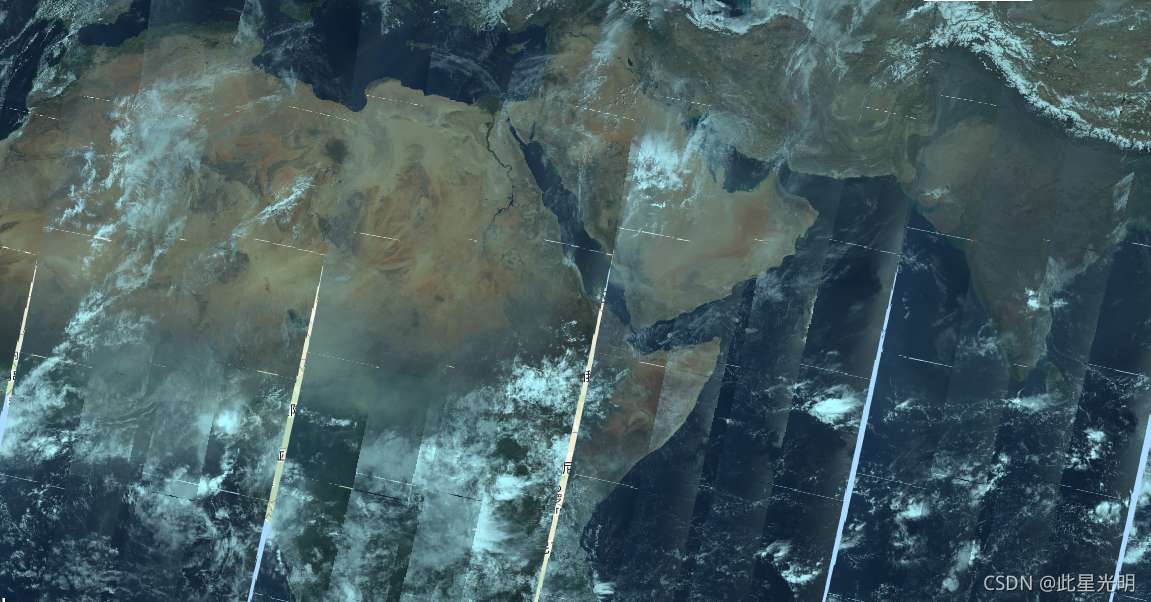
// Select bands for visualization and apply band-specific scale factors.
var rgb = dataset.select(['Oa08_radiance', 'Oa06_radiance', 'Oa04_radiance'])
.median()
// Convert to radiance units.
.multiply(ee.Image([0.00876539, 0.0123538, 0.0115198]));
var visParams = {
min: 0,
max: 6,
gamma: 1.5,
};
Map.setCenter(46.043, 1.45, 5);
Map.addLayer(rgb, visParams, 'RGB');影像:


 2647
2647

 被折叠的 条评论
为什么被折叠?
被折叠的 条评论
为什么被折叠?
 到【灌水乐园】发言


