


 FireCCI51是欧空局气候变化倡议的一个产品,提供250米分辨率的全球月度焚烧区数据。算法结合了Terra和Aqua卫星的MODIS传感器数据,通过两阶段检测方法识别烧毁区域。数据集包括烧毁日期、置信度、土地覆盖类型等信息,并提供未处理像素的原因。此数据集广泛应用于气候变化研究和监测。
The MODIS Fire_cci Burned Area pixel product version 5.1 (FireCCI51) is a monthly global ~250m spatial resolution dataset containing information on burned area as well as ancillary data. It is based on surface reflectance in the Near Infrared (NIR) band from the MODIS instrument onboard the Terra satellite, as well as active fire information from the same sensor of the Terra and Aqua satellites.
The burned area algorithm uses a two-phase hybrid approach. In a first step pixels with a high probability of being burned (called "seeds") are detected based on the active fires. In a second one, a contextual growing is applied to completely detect the fire patch. This growing phase is controlled by an adaptive thresholding, where thresholds are computed based on the specific characteristics of the area surrounding each seed. The variable used to guide the whole detection process is the NIR drop between pre- and post-fire images.
The dataset includes for each pixel the estimated day of the first detection of the fire, the confidence level of that detection, and the land cover that has been burned (extracted from the ESA CCI Land Cover dataset v2.0.7). In addition, an observation flag is provided to identify the pixels that were not processed due to the lack of valid observations or because they belong to a non-burnable land cover.
FireCCI51 was developed as part of the ESA Climate Change Initiative (CCI) Programme, and it is also part of the Copernicus Climate Change Service (C3S).
MODIS Fire_cci焚烧区像素产品5.1版(FireCCI51)是一个月度全球~250米空间分辨率的数据集,包含焚烧区信息以及辅助数据。它基于Terra卫星上的MODIS仪器的近红外(NIR)波段的表面反射率,以及Terra和Aqua卫星的同一传感器的主动火灾信息。
烧毁面积算法采用了两阶段的混合方法。在第一步中,根据活跃的火灾,检测出具有高概率被烧毁的像素(称为 "种子")。在第二步中,应用上下文增长来完全检测出火区。这个增长阶段由自适应阈值控制,其中阈值是根据每个种子周围地区的具体特征计算的。用来指导整个检测过程的变量是火灾前和火灾后图像之间的近红外下降。
数据集包括每个像素的首次探测火灾的估计日期、该探测的置信度以及已被烧毁的土地覆盖(从ESA CCI土地覆盖数据集v2.0.7提取)。此外,还提供了一个观测标志,以识别因缺乏有效观测或因属于非燃烧土地覆盖而未被处理的像素。
FireCCI51是作为欧空局气候变化倡议(CCI)计划的一部分而开发的,它也是哥白尼气候变化服务(C3S)的一部分。
Dataset Availability
2001-01-01T00:00:00 - 2019-12-31T00:00:00
Dataset Provider
European Space Agency (ESA) Climate Change Initiative (CCI) Programme, Fire ECV
Collection Snippet
ee.ImageCollection("ESA/CCI/FireCCI/5_1")
Resolution
0.0022457331 degrees
Bands Table
| Name | Description | Min | Max | Units |
|---|---|---|---|---|
| BurnDate | Estimated day of the year of the first detection of the burn | 1 | 366 | |
| ConfidenceLevel | Probability of detecting a pixel as burned, expressing the uncertainty of the detection for all pixels, even if they are classified as unburned. | 1 | 100 | % |
| LandCover | 'Land cover category of the burned pixels, extracted from the CCI LandCover v2.0.7 product. See Defourny, P., Lamarche, C., Bontemps, S., De Maet, T., Van Bogaert, E., Moreau, I., Brockmann, C., Boettcher, M., Kirches, G., Wevers, J., Santoro, M., Ramoino, F., & Arino, O. (2017). Land Cover Climate Change Initiative - Product User Guide v2. Issue 2.0. [online] Available at: https://maps.elie.ucl.ac.be/CCI/viewer/download/ESACCI-LC-Ph2-PUGv2_2.0.pdf accessed: July 2020. © ESA Climate Change Initiative - Land Cover led by UCLouvain (2017).' | |||
| ObservedFlag | Flags indicating why a pixel was not processed. * -2: the pixel is not burnable (water bodies, bare areas, urban areas, permanent snow and ice) * -1: the pixel has not been observed during the month (due to clouds, cloud shadows or sensor failure) |
Class Table: LandCover
| Value | Color | Color Value | Description |
|---|---|---|---|
| 0 | #ffff64 | Cropland, rainfed | |
| 20 | #aaf0f0 | Cropland, irrigated or post-flooding | |
| 30 | #dcf064 | Mosaic cropland (>50%) / natural vegetation (tree, shrub, herbaceous cover) (<50%) | |
| 40 | #c8c864 | Mosaic natural vegetation (tree, shrub, herbaceous cover) (>50%) / cropland (<50%) | |
| 50 | #006400 | Tree cover, broadleaved, evergreen, closed to open (>15%) | |
| 60 | #00a000 | Tree cover, broadleaved, deciduous, closed to open (>15%) | |
| 70 | #003c00 | Tree cover, needleleaved, evergreen, closed to open (>15%) | |
| 80 | #285000 | Tree cover, needleleaved, deciduous, closed to open (>15%) | |
| 90 | #788200 | Tree cover, mixed leaf type (broadleaved and needleleaved) | |
| 100 | #8ca000 | Mosaic tree and shrub (>50%) / herbaceous cover (<50%) | |
| 110 | #be9600 | Mosaic herbaceous cover (>50%) / tree and shrub (<50%) | |
| 120 | #966400 | Shrubland | |
| 130 | #ffb432 | Grassland | |
| 140 | #ffdcd2 | Lichens and mosses | |
| 150 | #ffebaf | Sparse vegetation (tree, shrub, herbaceous cover) (<15%) | |
| 170 | #009678 | Tree cover, flooded, saline water | |
| 180 | #00dc82 | Shrub or herbaceous cover, flooded, fresh/saline/brakish water |
This dataset is free and open to all users for any purpose, with the following terms and conditions:
-
Users of the data are required to acknowledge the ESA Climate Change Initiative and the Fire CCI project together with the individual data providers if the data are used in a presentation or publication. Please also cite any relevant dataset DOIs.
-
Intellectual property rights (IPR) in the CCI data lie with the researchers and organisations producing the data.
-
Liability: no warranty is given as to the quality or the accuracy of the CCI data or its suitability for any use. All implied conditions relating to the quality or suitability of the information, and all liabilities arising from the supply of the information (including any liability arising in negligence) are excluded to the fullest extent permitted by law.
该数据集免费开放给所有用户用于任何目的,但有以下条款和条件。
如果数据被用于演示或出版,数据用户必须承认欧空局气候变化倡议和火灾CCI项目,以及个别数据提供者。也请引用任何相关的数据集DOI。
CCI数据的知识产权(IPR)属于生产数据的研究人员和组织。
责任:不保证CCI数据的质量或准确性或其对任何用途的适用性。在法律允许的最大范围内,所有与信息的质量或适用性有关的隐含条件以及因提供信息而产生的所有责任(包括因疏忽而产生的任何责任)均被排除。
数据引用:
Product: Chuvieco, E.; Pettinari, M.L.; Lizundia-Loiola, J.; Storm, T.; Padilla Parellada, M. (2018): ESA Fire Climate Change Initiative (Fire_cci): MODIS Fire_cci Burned Area Pixel product, version 5.1. Centre for Environmental Data Analysis, 01 November 2018. https://doi.org/10.5285/58f00d8814064b79a0c49662ad3af537.
Related publication: Lizundia-Loiola, J., Otón, G., Ramo, R., Chuvieco, E. (2020): A spatio-temporal active-fire clustering approach for global burned area mapping at 250m from MODIS data. Remote Sensing of Environment, 236, 111493. https://doi.org/10.1016/j.rse.2019.111493
代码:
var dataset = ee.ImageCollection('ESA/CCI/FireCCI/5_1')
                  .filterDate('2019-01-01', '2019-12-31');
var burnedArea = dataset.select('BurnDate');

// Use a circular palette to assign colors to date of first detection
var baVis = {
  min: 1,
  max: 366,
  palette: [
    'ff0000', 'fd4100', 'fb8200', 'f9c400', 'f2ff00', 'b6ff05',
    '7aff0a', '3eff0f', '02ff15', '00ff55', '00ff99', '00ffdd',
    '00ddff', '0098ff', '0052ff', '0210ff', '3a0dfb', '7209f6',
    'a905f1', 'e102ed', 'ff00cc', 'ff0089', 'ff0047', 'ff0004'
  ]
};
var maxBA = burnedArea.max();

Map.setCenter(0, 18, 2.1);
Map.addLayer(maxBA, baVis, 'Burned Area');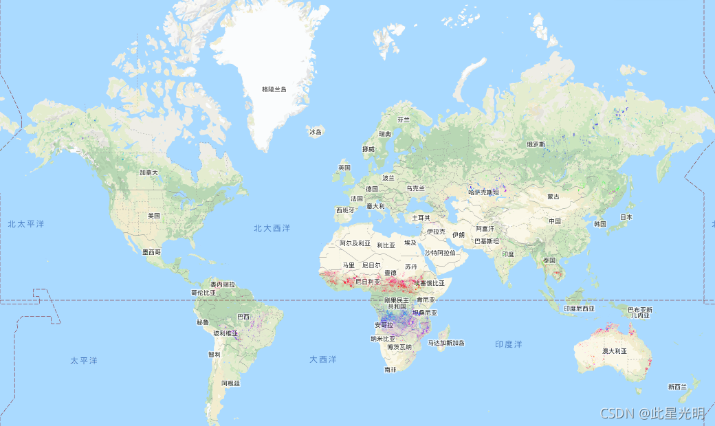


 1506
1506

 被折叠的 条评论
为什么被折叠?
被折叠的 条评论
为什么被折叠?
 到【灌水乐园】发言


